Property Record
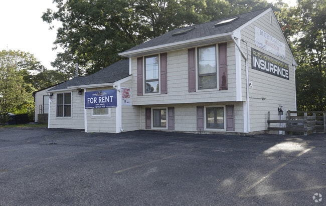
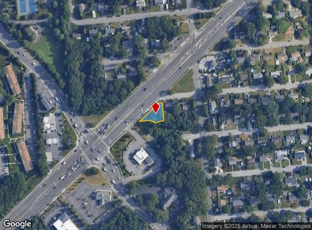
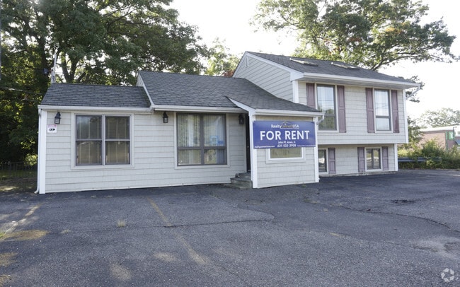
84 Nesconset Hwy, Port Jefferson Station, NY 11776
NEARBY LISTINGS FOR SALE OR LEASE
Property Detail
84 Nesconset Hwy
Nassau County-Suffolk County, NY
Port Jefferson Heights Park
0200-253-00-05-00-001-000
PT JEFF HTS PK 267 SEC E 1666 TO 16
Commercialnec
Suffolk
X
New York
36103C0390H
1
2024
0.18 AC
2024
Central Suffolk
158327
Long Island (New York)
DEMOGRAPHICS near 84 Nesconset Hwy
1 Mile
3 Mile
5 Mile
2024 Total Population
11,102
87,923
197,462
2029 Population
10,864
86,730
194,673
Pop Growth 2024-2029
(2.14%)
(1.36%)
(1.41%)
Average Age
43
40
41
2024 Total Households
3,960
27,710
64,436
HH Growth 2024-2029
(2.47%)
(1.57%)
(1.64%)
Median Household Inc
$116,752
$120,616
$118,042
Avg Household Size
2.70
2.80
2.80
2024 Avg HH Vehicles
2.00
2.00
2.00
Median Home Value
$438,226
$465,046
$468,703
Median Year Built
1971
1971
1973
Nearby Places
- Restaurants
- Banks
- Shops
- Fitness
- Groceries
PUBLIC TRANSPORTATION
COMMUTER RAIL
Port Jefferson Station (Port Jefferson Branch - Long Island Rail Road)
DRIVE
WALK
Distance
Port Jefferson Station (Port Jefferson Branch - Long Island Rail Road)
5 min
2.1 mi
St James Station (Port Jefferson Branch - Long Island Rail Road)
DRIVE
WALK
Distance
St James Station (Port Jefferson Branch - Long Island Rail Road)
15 min
7.5 mi
AIRPORT
Long Island MacArthur
DRIVE
WALK
Distance
Long Island MacArthur
25 min
14.8 mi
Freight Ports
NY - Red Hook Container Terminal
DRIVE
WALK
Distance
NY - Red Hook Container Terminal
1 min
51.7 mi
SALE & LEASE HISTORY
LISTING DATE
SALE/LEASE

Oct 11, 2018
For Lease
Nearby Properties
Address
Land Use
TOTAL SIZE
Lot Size
Zoning
Address
Land Use
TOTAL SIZE
Lot Size
Zoning
31.31 AC
Address
Land Use
TOTAL SIZE
Lot Size
Zoning
6,522 SF
0.32 AC
VILLA
Address
Land Use
TOTAL SIZE
Lot Size
Zoning
41.35 AC
Address
Land Use
TOTAL SIZE
Lot Size
Zoning
1.22 AC
CR80
Address
Land Use
TOTAL SIZE
Lot Size
Zoning
0.92 AC
CR80
Address
Land Use
TOTAL SIZE
Lot Size
Zoning
3.52 AC
CR80
Address
Land Use
TOTAL SIZE
Lot Size
Zoning
39.56 AC
Address
Land Use
TOTAL SIZE
Lot Size
Zoning
23.75 AC
Address
Land Use
TOTAL SIZE
Lot Size
Zoning
Address
Land Use
TOTAL SIZE
Lot Size
Zoning
13.70 AC
Address
Land Use
TOTAL SIZE
Lot Size
Zoning
21.04 AC
Address
Land Use
TOTAL SIZE
Lot Size
Zoning
Address
Land Use
TOTAL SIZE
Lot Size
Zoning
18.80 AC
Address
Land Use
TOTAL SIZE
Lot Size
Zoning
31.50 AC
Address
Land Use
TOTAL SIZE
Lot Size
Zoning
64.87 AC
Address
Land Use
TOTAL SIZE
Lot Size
Zoning
3,876 SF
0.17 AC
VILLA
Address
Land Use
TOTAL SIZE
Lot Size
Zoning
17.50 AC
Address
Land Use
TOTAL SIZE
Lot Size
Zoning
19.28 AC
Address
Land Use
TOTAL SIZE
Lot Size
Zoning
Address
Land Use
TOTAL SIZE
Lot Size
Zoning
49.83 AC
Address
Land Use
TOTAL SIZE
Lot Size
Zoning
Address
Land Use
TOTAL SIZE
Lot Size
Zoning
Address
Land Use
TOTAL SIZE
Lot Size
Zoning
Address
Land Use
TOTAL SIZE
Lot Size
Zoning
Address
Land Use
TOTAL SIZE
Lot Size
Zoning
0.54 AC
R20
Address
Land Use
TOTAL SIZE
Lot Size
Zoning
Address
Land Use
TOTAL SIZE
Lot Size
Zoning
Address
Land Use
TOTAL SIZE
Lot Size
Zoning
Address
Land Use
TOTAL SIZE
Lot Size
Zoning
Address
Land Use
TOTAL SIZE
Lot Size
Zoning
The World's #1 Commercial Real Estate Marketplace
Connect with us
© 2025 CoStar Group
The information above has been obtained from sources believed reliable. While we do not doubt its accuracy we have not verified it and make no guarantee, warranty or representation about it. It is your responsibility to independently confirm its accuracy and completeness. Any projections, opinions, assumptions, or estimates used are for example only and do not represent the current or future performance of the property. The value of this transaction to you depends on tax and other factors which should be evaluated by your tax, financial, and legal advisors. You and your advisors should conduct a careful, independent investigation of the property to determine to your satisfaction the suitability of the property for your needs.