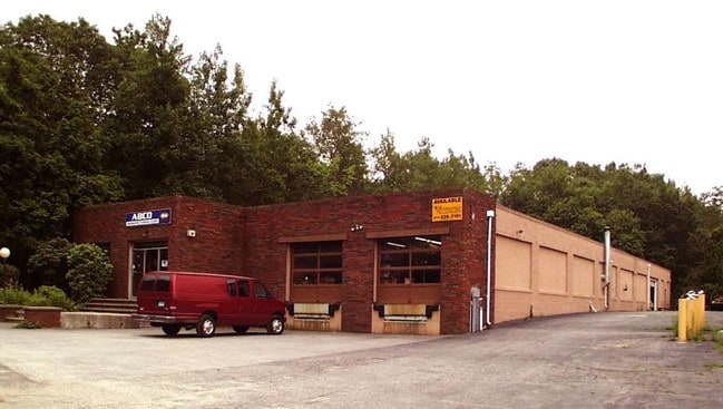
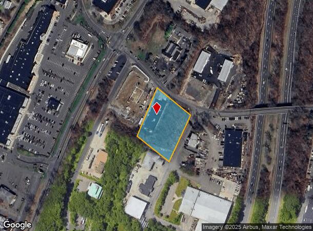
Property Record
84 Platt Rd, Shelton, CT 06484
NEARBY LISTINGS FOR SALE OR LEASE
Property Detail
84 Platt Rd
SHEL-000077-000000-000024
Fairfield
Industrialgeneral
Connecticut
X
24
09001C0315F
1.51 AC
2025
Shelton
2025
Westchester/So Connecticut
110202
Bridgeport-Stamford-Norwalk, CT
10,032 SF
DEMOGRAPHICS near 84 Platt Rd
1 Mile
3 Mile
5 Mile
2024 Total Population
3,139
46,274
109,727
2029 Population
3,163
46,543
109,911
Pop Growth 2024-2029
+ 0.76%
+ 0.58%
+ 0.17%
Average Age
48
44
44
2024 Total Households
1,418
19,378
43,313
HH Growth 2024-2029
+ 0.63%
+ 0.52%
+ 0.13%
Median Household Inc
$72,980
$88,036
$97,504
Avg Household Size
2.20
2.30
2.50
2024 Avg HH Vehicles
2.00
2.00
2.00
Median Home Value
$325,225
$344,432
$358,683
Median Year Built
1984
1974
1969
Nearby Places
Map Layers
Map Styles
 Street
 Aerial
- Restaurants
- Banks
- Shops
- Fitness
- Groceries
PUBLIC TRANSPORTATION
COMMUTER RAIL
Derby-Shelton Station (New Haven Line - Metro-North Commuter Railroad Company (Metro-North))
DRIVE
WALK
Distance
Derby-Shelton Station (New Haven Line - Metro-North Commuter Railroad Company (Metro-North))
5 min
2.5 mi
Ansonia Station (New Haven Line - Metro-North Commuter Railroad Company (Metro-North))
DRIVE
WALK
Distance
Ansonia Station (New Haven Line - Metro-North Commuter Railroad Company (Metro-North))
8 min
4.2 mi
AIRPORT
Tweed/New Haven
DRIVE
WALK
Distance
Tweed/New Haven
29 min
15.9 mi
Westchester County
DRIVE
WALK
Distance
Westchester County
61 min
42.9 mi
Long Island MacArthur
DRIVE
WALK
Distance
Long Island MacArthur
122 min
44.8 mi
Freight Ports
Port of New Haven
DRIVE
WALK
Distance
Port of New Haven
23 min
13.7 mi
SALE & LEASE HISTORY
LISTING DATE
SALE/LEASE

Sep 24, 2016
For Lease
Sep 23, 2016
For Sale
Oct 18, 2018
For Sale
Feb 15, 2017
For Sale
Nearby Properties
Address
Land Use
TOTAL SIZE
Lot Size
Zoning
Address
Land Use
TOTAL SIZE
Lot Size
Zoning
68,102 SF
4.44 AC
IB-2
Address
Land Use
TOTAL SIZE
Lot Size
Zoning
1,444 SF
50.40 AC
R-1
Address
Land Use
TOTAL SIZE
Lot Size
Zoning
236,601 SF
12.85 AC
IA-3
Address
Land Use
TOTAL SIZE
Lot Size
Zoning
4,320 SF
29.27 AC
R-1
Address
Land Use
TOTAL SIZE
Lot Size
Zoning
287,760 SF
4.98 AC
PDD6
Address
Land Use
TOTAL SIZE
Lot Size
Zoning
287,760 SF
6.32 AC
PDD6
Address
Land Use
TOTAL SIZE
Lot Size
Zoning
172,324 SF
46.29 AC
R-1
Address
Land Use
TOTAL SIZE
Lot Size
Zoning
271,336 SF
11.45 AC
PDD2
Address
Land Use
TOTAL SIZE
Lot Size
Zoning
168,139 SF
7.90 AC
LIP
Address
Land Use
TOTAL SIZE
Lot Size
Zoning
249,462 SF
21.79 AC
IB-1
Address
Land Use
TOTAL SIZE
Lot Size
Zoning
11.73 AC
CB-1
Address
Land Use
TOTAL SIZE
Lot Size
Zoning
3,040 SF
7.07 AC
PDD5
Address
Land Use
TOTAL SIZE
Lot Size
Zoning
52.09 AC
P
Address
Land Use
TOTAL SIZE
Lot Size
Zoning
300,288 SF
12.50 AC
PDD2
Address
Land Use
TOTAL SIZE
Lot Size
Zoning
4,715 SF
20.76 AC
PDD2
Address
Land Use
TOTAL SIZE
Lot Size
Zoning
454,846 SF
36.10 AC
IA-3
Address
Land Use
TOTAL SIZE
Lot Size
Zoning
2,046 SF
625.72 AC
R-1
Address
Land Use
TOTAL SIZE
Lot Size
Zoning
158,266 SF
7.95 AC
PDD6
Address
Land Use
TOTAL SIZE
Lot Size
Zoning
22,560 SF
68.78 AC
PDD1
Address
Land Use
TOTAL SIZE
Lot Size
Zoning
10,761 SF
11.72 AC
PDD
Address
Land Use
TOTAL SIZE
Lot Size
Zoning
54,475 SF
2.78 AC
1A-2
Address
Land Use
TOTAL SIZE
Lot Size
Zoning
33,880 SF
3 AC
LIP
Address
Land Use
TOTAL SIZE
Lot Size
Zoning
13,111 SF
6.49 AC
IA-2
Address
Land Use
TOTAL SIZE
Lot Size
Zoning
147,168 SF
8.83 AC
R-1
Address
Land Use
TOTAL SIZE
Lot Size
Zoning
152,016 SF
9.97 AC
OPD
Address
Land Use
TOTAL SIZE
Lot Size
Zoning
133,200 SF
10.69 AC
PDD6
Address
Land Use
TOTAL SIZE
Lot Size
Zoning
156,893 SF
15.46 AC
IB-1
Address
Land Use
TOTAL SIZE
Lot Size
Zoning
84,275 SF
1.43 AC
IA-3
Address
Land Use
TOTAL SIZE
Lot Size
Zoning
110,888 SF
5.27 AC
IA-2
Address
Land Use
TOTAL SIZE
Lot Size
Zoning
152,842 SF
15.02 AC
PDD1
The World's #1 Commercial Real Estate Marketplace
Connect with us
© 2025 CoStar Group
The information above has been obtained from sources believed reliable. While we do not doubt its accuracy we have not verified it and make no guarantee, warranty or representation about it. It is your responsibility to independently confirm its accuracy and completeness. Any projections, opinions, assumptions, or estimates used are for example only and do not represent the current or future performance of the property. The value of this transaction to you depends on tax and other factors which should be evaluated by your tax, financial, and legal advisors. You and your advisors should conduct a careful, independent investigation of the property to determine to your satisfaction the suitability of the property for your needs.