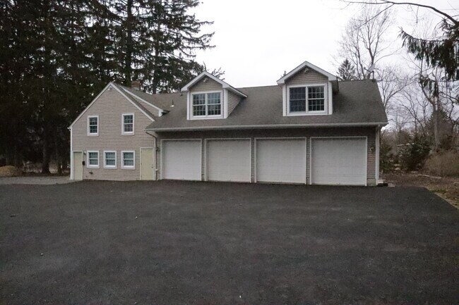
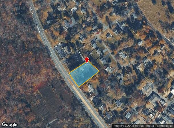
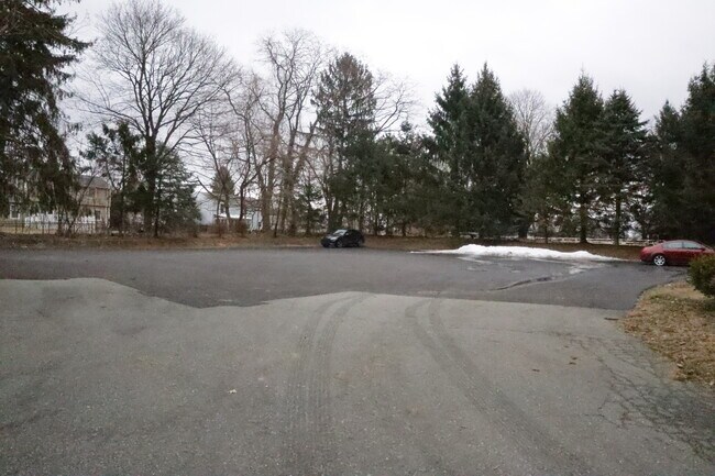
Property Record
84 South Rd S, Chester, NJ 07930
NEARBY LISTINGS FOR SALE OR LEASE
-
-
View all Chester listings for lease on LoopNet.com
Property Detail
84 South Rd S
Newark, NJ-PA
Morris
06-00103-0000-00049
New Jersey
Commercialnec
49
2024
0.95 AC
2025
Route 80 Corridor
045901
Northern New Jersey
1,318 SF
DEMOGRAPHICS near 84 South Rd S
1 Mile
3 Mile
5 Mile
2024 Total Population
2,448
10,747
36,112
2029 Population
2,442
10,717
35,874
Pop Growth 2024-2029
(0.25%)
(0.28%)
(0.66%)
Average Age
43
43
42
2024 Total Households
891
3,754
12,675
HH Growth 2024-2029
(0.34%)
(0.29%)
(0.82%)
Median Household Inc
$146,265
$160,786
$160,003
Avg Household Size
2.70
2.80
2.80
2024 Avg HH Vehicles
2.00
2.00
2.00
Median Home Value
$664,221
$628,034
$578,204
Median Year Built
1973
1975
1975
Nearby Places
Map Layers
Map Styles
 Street
 Aerial
- Restaurants
- Banks
- Shops
- Fitness
- Groceries
PUBLIC TRANSPORTATION
COMMUTER RAIL
Gladstone (Morris & Essex Gladstone Branch - NJ Transit Commuter Rail (NJ Transit))
DRIVE
WALK
Distance
Gladstone (Morris & Essex Gladstone Branch - NJ Transit Commuter Rail (NJ Transit))
9 min
5.3 mi
Peapack (Morris & Essex Gladstone Branch - NJ Transit Commuter Rail (NJ Transit))
DRIVE
WALK
Distance
Peapack (Morris & Essex Gladstone Branch - NJ Transit Commuter Rail (NJ Transit))
11 min
6.4 mi
AIRPORT
Newark Liberty International
DRIVE
WALK
Distance
Newark Liberty International
49 min
34.8 mi
Freight Ports
Maher Terminal
DRIVE
WALK
Distance
Maher Terminal
51 min
35.3 mi
SALE & LEASE HISTORY
LISTING DATE
SALE/LEASE

Mar 24, 2025
For Lease
Nearby Properties
Address
Land Use
TOTAL SIZE
Lot Size
Zoning
Address
Land Use
TOTAL SIZE
Lot Size
Zoning
242 AC
G-I
Address
Land Use
TOTAL SIZE
Lot Size
Zoning
21.56 AC
B-3
Address
Land Use
TOTAL SIZE
Lot Size
Zoning
50.50 AC
R-5
Address
Land Use
TOTAL SIZE
Lot Size
Zoning
104,682 SF
8.96 AC
B-3
Address
Land Use
TOTAL SIZE
Lot Size
Zoning
720 SF
1,022.40 AC
R-2
Address
Land Use
TOTAL SIZE
Lot Size
Zoning
27.40 AC
P
Address
Land Use
TOTAL SIZE
Lot Size
Zoning
610.04 AC
R-5
Address
Land Use
TOTAL SIZE
Lot Size
Zoning
39.63 AC
P
Address
Land Use
TOTAL SIZE
Lot Size
Zoning
49,548 SF
19.99 AC
P
Address
Land Use
TOTAL SIZE
Lot Size
Zoning
158,800 SF
18.40 AC
G-I
Address
Land Use
TOTAL SIZE
Lot Size
Zoning
65,914 SF
7.25 AC
B-3
Address
Land Use
TOTAL SIZE
Lot Size
Zoning
1,036 SF
285.42 AC
P
Address
Land Use
TOTAL SIZE
Lot Size
Zoning
52,027 SF
33.23 AC
R-2
Address
Land Use
TOTAL SIZE
Lot Size
Zoning
83,616 SF
36.79 AC
G-I
Address
Land Use
TOTAL SIZE
Lot Size
Zoning
1,516 SF
40.74 AC
R-LD
Address
Land Use
TOTAL SIZE
Lot Size
Zoning
3,328 SF
12.65 AC
B-2
Address
Land Use
TOTAL SIZE
Lot Size
Zoning
222.10 AC
R-3
Address
Land Use
TOTAL SIZE
Lot Size
Zoning
213.55 AC
R-5
Address
Land Use
TOTAL SIZE
Lot Size
Zoning
10,889 SF
2.40 AC
R-HD
Address
Land Use
TOTAL SIZE
Lot Size
Zoning
146 AC
P
Address
Land Use
TOTAL SIZE
Lot Size
Zoning
9.52 AC
IL
Address
Land Use
TOTAL SIZE
Lot Size
Zoning
31,680 SF
3.23 AC
OP
Address
Land Use
TOTAL SIZE
Lot Size
Zoning
34.66 AC
R-5
Address
Land Use
TOTAL SIZE
Lot Size
Zoning
28,260 SF
2.84 AC
B-3
Address
Land Use
TOTAL SIZE
Lot Size
Zoning
64.01 AC
I
Address
Land Use
TOTAL SIZE
Lot Size
Zoning
151.11 AC
R-2
Address
Land Use
TOTAL SIZE
Lot Size
Zoning
22,907 SF
1.88 AC
C-2
Address
Land Use
TOTAL SIZE
Lot Size
Zoning
1,331 SF
7.44 AC
R-2
Address
Land Use
TOTAL SIZE
Lot Size
Zoning
44 AC
BE
Address
Land Use
TOTAL SIZE
Lot Size
Zoning
103.72 AC
IL
The World's #1 Commercial Real Estate Marketplace
Connect with us
© 2025 CoStar Group
The information above has been obtained from sources believed reliable. While we do not doubt its accuracy we have not verified it and make no guarantee, warranty or representation about it. It is your responsibility to independently confirm its accuracy and completeness. Any projections, opinions, assumptions, or estimates used are for example only and do not represent the current or future performance of the property. The value of this transaction to you depends on tax and other factors which should be evaluated by your tax, financial, and legal advisors. You and your advisors should conduct a careful, independent investigation of the property to determine to your satisfaction the suitability of the property for your needs.