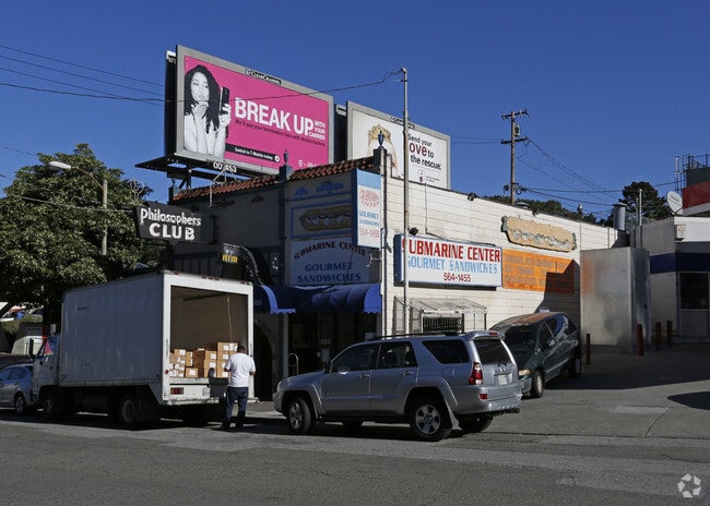
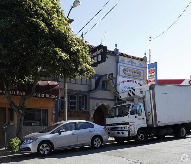
Property Record
840 Ulloa St, San Francisco, CA 94127

NEARBY LISTINGS FOR SALE OR LEASE
Property Detail
840 Ulloa St
San Francisco-Redwood City-South San Francisco, CA
Claremont Court
2979-013
San Francisco
Storemultistory
California
2024
12
2025
0.07 AC
030800
Southern City
1,920 SF
San Francisco
DEMOGRAPHICS near 840 Ulloa St
1 Mile
3 Mile
5 Mile
2024 Total Population
32,227
418,353
838,374
2029 Population
29,363
385,105
776,061
Pop Growth 2024-2029
(8.89%)
(7.95%)
(7.43%)
Average Age
46
43
42
2024 Total Households
11,554
160,286
342,197
HH Growth 2024-2029
(9.50%)
(8.31%)
(7.81%)
Median Household Inc
$166,505
$136,667
$123,058
Avg Household Size
2.70
2.50
2.30
2024 Avg HH Vehicles
2.00
1.00
1.00
Median Home Value
$1,134,543
$1,104,393
$1,091,391
Median Year Built
1947
1948
1949
Nearby Places
- Restaurants
- Banks
- Shops
- Fitness
- Groceries
PUBLIC TRANSPORTATION
TRANSIT/SUBWAY
West Portal (INGLESIDE - San Francisco Municipal Railway (MUNI Metro), K Ingleside - San Francisco Municipal Railway (MUNI Metro), L Taraval - San Francisco Municipal Railway (MUNI Metro), M Ocean View - San Francisco Municipal Railway (MUNI Metro), OCEAN VIEW - San Francisco Municipal Railway (MUNI Metro), T Third Street - San Francisco Municipal Railway (MUNI Metro), TARAVAL - San Francisco Municipal Railway (MUNI Metro))
DRIVE
WALK
Distance
West Portal (INGLESIDE - San Francisco Municipal Railway (MUNI Metro), K Ingleside - San Francisco Municipal Railway (MUNI Metro), L Taraval - San Francisco Municipal Railway (MUNI Metro), M Ocean View - San Francisco Municipal Railway (MUNI Metro), OCEAN VIEW - San Francisco Municipal Railway (MUNI Metro), T Third Street - San Francisco Municipal Railway (MUNI Metro), TARAVAL - San Francisco Municipal Railway (MUNI Metro))
0 min
0 min
0.0 mi
Ulloa St & Lenox Way (OCEAN VIEW - San Francisco Municipal Transportation Agency, TARAVAL - San Francisco Municipal Transportation Agency)
DRIVE
WALK
Distance
Ulloa St & Lenox Way (OCEAN VIEW - San Francisco Municipal Transportation Agency, TARAVAL - San Francisco Municipal Transportation Agency)
0 min
0 min
0.0 mi
Ulloa St & 14Th Ave (TARAVAL - San Francisco Municipal Transportation Agency)
DRIVE
WALK
Distance
Ulloa St & 14Th Ave (TARAVAL - San Francisco Municipal Transportation Agency)
1 min
5 min
0.3 mi
West Portal And 14Th Avenue (INGLESIDE - San Francisco Municipal Railway (MUNI Metro), K Ingleside - San Francisco Municipal Railway (MUNI Metro), M Ocean View - San Francisco Municipal Railway (MUNI Metro), OCEAN VIEW - San Francisco Municipal Railway (MUNI Metro))
DRIVE
WALK
Distance
West Portal And 14Th Avenue (INGLESIDE - San Francisco Municipal Railway (MUNI Metro), K Ingleside - San Francisco Municipal Railway (MUNI Metro), M Ocean View - San Francisco Municipal Railway (MUNI Metro), OCEAN VIEW - San Francisco Municipal Railway (MUNI Metro))
1 min
5 min
0.3 mi
15Th Ave & Taraval St (TARAVAL - San Francisco Municipal Transportation Agency)
DRIVE
WALK
Distance
15Th Ave & Taraval St (TARAVAL - San Francisco Municipal Transportation Agency)
1 min
8 min
0.4 mi
COMMUTER RAIL
Bayshore Caltrain Station (Local - Caltrain (Caltrain), Local Weekday - Caltrain (Caltrain), Local Weekend - Caltrain (Caltrain))
DRIVE
WALK
Distance
Bayshore Caltrain Station (Local - Caltrain (Caltrain), Local Weekday - Caltrain (Caltrain), Local Weekend - Caltrain (Caltrain))
11 min
5.6 mi
22Nd Street (Caltrain - Caltrain (Caltrain))
DRIVE
WALK
Distance
22Nd Street (Caltrain - Caltrain (Caltrain))
11 min
6.7 mi
AIRPORT
San Francisco International
DRIVE
WALK
Distance
San Francisco International
20 min
12.7 mi
Metro Oakland International
DRIVE
WALK
Distance
Metro Oakland International
40 min
26.2 mi
Freight Ports
Port of San Francisco
DRIVE
WALK
Distance
Port of San Francisco
16 min
8.8 mi
Nearby Properties
Address
Land Use
TOTAL SIZE
Lot Size
Zoning
Address
Land Use
TOTAL SIZE
Lot Size
Zoning
248,303 SF
4.35 AC
Address
Land Use
TOTAL SIZE
Lot Size
Zoning
411,904 SF
21.74 AC
C2
Address
Land Use
TOTAL SIZE
Lot Size
Zoning
718 SF
18.55 AC
RH2
Address
Land Use
TOTAL SIZE
Lot Size
Zoning
346,710 SF
7.45 AC
RH2
Address
Land Use
TOTAL SIZE
Lot Size
Zoning
409,895 SF
7.20 AC
RH3
Address
Land Use
TOTAL SIZE
Lot Size
Zoning
312,191 SF
2.74 AC
Address
Land Use
TOTAL SIZE
Lot Size
Zoning
17.91 AC
RH-2
Address
Land Use
TOTAL SIZE
Lot Size
Zoning
4.41 AC
RH-3/RM-2
Address
Land Use
TOTAL SIZE
Lot Size
Zoning
230,310 SF
0.65 AC
NC3
Address
Land Use
TOTAL SIZE
Lot Size
Zoning
2.03 AC
C2
Address
Land Use
TOTAL SIZE
Lot Size
Zoning
88,900 SF
5.37 AC
NCS
Address
Land Use
TOTAL SIZE
Lot Size
Zoning
80,000 SF
0.48 AC
RM1
Address
Land Use
TOTAL SIZE
Lot Size
Zoning
11.31 AC
RM2
Address
Land Use
TOTAL SIZE
Lot Size
Zoning
160,983 SF
1.84 AC
NC2
Address
Land Use
TOTAL SIZE
Lot Size
Zoning
75,989 SF
0.72 AC
Address
Land Use
TOTAL SIZE
Lot Size
Zoning
90,539 SF
2.28 AC
RH2
Address
Land Use
TOTAL SIZE
Lot Size
Zoning
Address
Land Use
TOTAL SIZE
Lot Size
Zoning
70,563 SF
0.42 AC
Address
Land Use
TOTAL SIZE
Lot Size
Zoning
88,402 SF
1.03 AC
RM1RM2
Address
Land Use
TOTAL SIZE
Lot Size
Zoning
73,491 SF
4.48 AC
C2
Address
Land Use
TOTAL SIZE
Lot Size
Zoning
12,555 SF
0.74 AC
NCS
Address
Land Use
TOTAL SIZE
Lot Size
Zoning
146,036 SF
0.49 AC
RH3
Address
Land Use
TOTAL SIZE
Lot Size
Zoning
176,000 SF
1.64 AC
C2
Address
Land Use
TOTAL SIZE
Lot Size
Zoning
0.06 AC
UPMKT
Address
Land Use
TOTAL SIZE
Lot Size
Zoning
132,123 SF
0.54 AC
NC3
Address
Land Use
TOTAL SIZE
Lot Size
Zoning
54,131 SF
1.75 AC
C2
Address
Land Use
TOTAL SIZE
Lot Size
Zoning
50,461 SF
0.43 AC
UPMKT
Address
Land Use
TOTAL SIZE
Lot Size
Zoning
76,000 SF
1.48 AC
RM4
Address
Land Use
TOTAL SIZE
Lot Size
Zoning
194,477 SF
11.37 AC
RH1
Address
Land Use
TOTAL SIZE
Lot Size
Zoning
67,432 SF
4.55 AC
CL00C1
The World's #1 Commercial Real Estate Marketplace
Connect with us
© 2025 CoStar Group
The information above has been obtained from sources believed reliable. While we do not doubt its accuracy we have not verified it and make no guarantee, warranty or representation about it. It is your responsibility to independently confirm its accuracy and completeness. Any projections, opinions, assumptions, or estimates used are for example only and do not represent the current or future performance of the property. The value of this transaction to you depends on tax and other factors which should be evaluated by your tax, financial, and legal advisors. You and your advisors should conduct a careful, independent investigation of the property to determine to your satisfaction the suitability of the property for your needs.