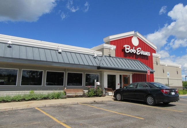
Property Record
840 Perry Ave, Big Rapids, MI 49307

Property Detail
840 Perry Ave
5417-015-300-006
000840 PERRY AVENUE: SEC 15, T15N, R10W -- A PARCEL OF LAND COM AT THE S 1/4 COR OF SD SEC, TH N 00 05' 27" W ALG THE N/S 1/
Commercialnec
Mecosta
B and X Area of moderate flood hazard, usually the area between the limits of the 100-year and 500-year floods.
Michigan
2024
1.14 AC
2025
Michigan North Central Area
960600
Other Market Areas
3,638 SF
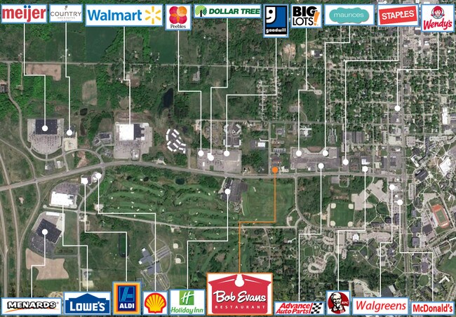
Big Rapids, MI
NEARBY LISTINGS FOR SALE OR LEASE
DEMOGRAPHICS near 840 Perry Ave
1 mile
3 mile
5 mile
2025 Total Population
4,066
14,763
18,481
2030 Population
4,244
15,783
19,459
Pop Growth 2025-2030
+ 4.38%
+ 6.91%
+ 5.29%
Average Age
29
35
36
2025 Total Households
1,266
5,698
7,168
HH Growth 2025-2030
+ 3.16%
+ 6.90%
+ 5.29%
Median Household Inc
$51,038
$46,586
$51,208
Avg Household Size
2.10
2.20
2.20
2025 Avg HH Vehicles
2.00
2.00
2.00
Median Home Value
$188,486
$188,320
$192,141
Median Year Built
1974
1986
1984
Nearby Places
Map Layers
Map Styles
 Street
 Aerial
Transit
 Traffic
 Biking
Places
Listings with unknown addresses are not visible on the map
- Restaurants
- Banks
- Shops
- Fitness
- Groceries
SALE & LEASE HISTORY
LISTING DATE
SALE/LEASE

May 26, 2017
For Sale
Nearby Properties
Address
Land Use
TOTAL SIZE
Lot Size
Zoning
Address
Land Use
TOTAL SIZE
Lot Size
Zoning
270,869 SF
19.75 AC
Address
Land Use
TOTAL SIZE
Lot Size
Zoning
56.64 AC
Address
Land Use
TOTAL SIZE
Lot Size
Zoning
205,711 SF
30.37 AC
Address
Land Use
TOTAL SIZE
Lot Size
Zoning
16.08 AC
Address
Land Use
TOTAL SIZE
Lot Size
Zoning
20,760 SF
36.80 AC
Address
Land Use
TOTAL SIZE
Lot Size
Zoning
95,044 SF
12.16 AC
Address
Land Use
TOTAL SIZE
Lot Size
Zoning
9.65 AC
Address
Land Use
TOTAL SIZE
Lot Size
Zoning
29.09 AC
Address
Land Use
TOTAL SIZE
Lot Size
Zoning
Address
Land Use
TOTAL SIZE
Lot Size
Zoning
23,240 SF
7.41 AC
Address
Land Use
TOTAL SIZE
Lot Size
Zoning
18,387 SF
6.21 AC
Address
Land Use
TOTAL SIZE
Lot Size
Zoning
10,080 SF
18.85 AC
Address
Land Use
TOTAL SIZE
Lot Size
Zoning
10,443 SF
5.81 AC
Address
Land Use
TOTAL SIZE
Lot Size
Zoning
14.05 AC
Address
Land Use
TOTAL SIZE
Lot Size
Zoning
60,416 SF
5.40 AC
Address
Land Use
TOTAL SIZE
Lot Size
Zoning
89,079 SF
6.90 AC
Address
Land Use
TOTAL SIZE
Lot Size
Zoning
14,094 SF
9.43 AC
Address
Land Use
TOTAL SIZE
Lot Size
Zoning
35.44 AC
Address
Land Use
TOTAL SIZE
Lot Size
Zoning
Address
Land Use
TOTAL SIZE
Lot Size
Zoning
103,416 SF
23.68 AC
Address
Land Use
TOTAL SIZE
Lot Size
Zoning
Address
Land Use
TOTAL SIZE
Lot Size
Zoning
11,319 SF
3.41 AC
Address
Land Use
TOTAL SIZE
Lot Size
Zoning
12.54 AC
Address
Land Use
TOTAL SIZE
Lot Size
Zoning
25,434 SF
4.39 AC
Address
Land Use
TOTAL SIZE
Lot Size
Zoning
131,210 SF
6.11 AC
Address
Land Use
TOTAL SIZE
Lot Size
Zoning
12,960 SF
6.14 AC
Address
Land Use
TOTAL SIZE
Lot Size
Zoning
20,300 SF
6.36 AC
Address
Land Use
TOTAL SIZE
Lot Size
Zoning
Address
Land Use
TOTAL SIZE
Lot Size
Zoning
39,316 SF
3.54 AC
Address
Land Use
TOTAL SIZE
Lot Size
Zoning
26,520 SF
2.11 AC
The World's #1 Commercial Real Estate Marketplace
Connect with us
© 2026 CoStar Group
The information above has been obtained from sources believed reliable. While we do not doubt its accuracy we have not verified it and make no guarantee, warranty or representation about it. It is your responsibility to independently confirm its accuracy and completeness. Any projections, opinions, assumptions, or estimates used are for example only and do not represent the current or future performance of the property. The value of this transaction to you depends on tax and other factors which should be evaluated by your tax, financial, and legal advisors. You and your advisors should conduct a careful, independent investigation of the property to determine to your satisfaction the suitability of the property for your needs.