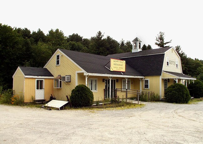
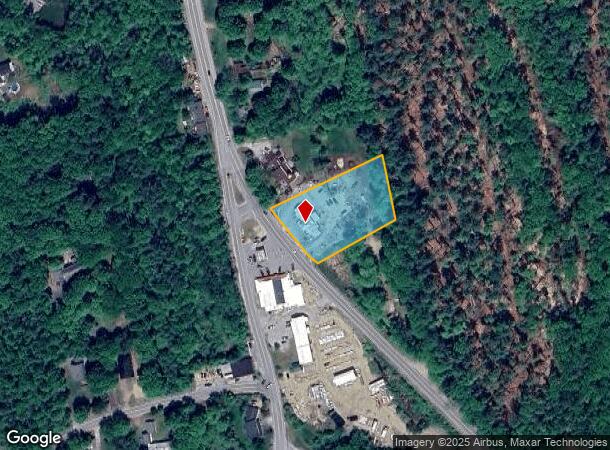
Property Record
840 S Stark Hwy, Weare, NH 03281
NEARBY LISTINGS FOR SALE OR LEASE
Property Detail
840 S Stark Hwy
WEAR-000408-000000-000165
Hillsborough
Commercialbuilding
New Hampshire
X
165
33011C0190D
1.32 AC
2024
Hillsborough
2024
Boston
021001
Manchester-Nashua, NH
4,277 SF
DEMOGRAPHICS near 840 S Stark Hwy
1 Mile
3 Mile
5 Mile
2024 Total Population
740
5,019
11,203
2029 Population
760
5,162
11,521
Pop Growth 2024-2029
+ 2.70%
+ 2.85%
+ 2.84%
Average Age
40
40
41
2024 Total Households
266
1,828
4,091
HH Growth 2024-2029
+ 2.26%
+ 2.84%
+ 2.86%
Median Household Inc
$112,259
$108,235
$110,187
Avg Household Size
2.80
2.70
2.70
2024 Avg HH Vehicles
2.00
2.00
2.00
Median Home Value
$340,853
$340,232
$347,207
Median Year Built
1984
1984
1985
Nearby Places
Map Layers
Map Styles
 Street
 Aerial
- Restaurants
- Banks
- Shops
- Fitness
- Groceries
PUBLIC TRANSPORTATION
AIRPORT
Manchester Boston Regional
DRIVE
WALK
Distance
Manchester Boston Regional
39 min
20.0 mi
Freight Ports
Port of Boston
DRIVE
WALK
Distance
Port of Boston
98 min
69.7 mi
Nearby Properties
Address
Land Use
TOTAL SIZE
Lot Size
Zoning
Address
Land Use
TOTAL SIZE
Lot Size
Zoning
113,110 SF
14.70 AC
VILL S
Address
Land Use
TOTAL SIZE
Lot Size
Zoning
3,570 SF
108.02 AC
COMMER
Address
Land Use
TOTAL SIZE
Lot Size
Zoning
3,450 SF
6.03 AC
COMMER
Address
Land Use
TOTAL SIZE
Lot Size
Zoning
8,547 SF
7.97 AC
COMMER
Address
Land Use
TOTAL SIZE
Lot Size
Zoning
16,927 SF
7.28 AC
COMMER
Address
Land Use
TOTAL SIZE
Lot Size
Zoning
2,964 SF
18.46 AC
COMMER
Address
Land Use
TOTAL SIZE
Lot Size
Zoning
15,434 SF
COMMER
Address
Land Use
TOTAL SIZE
Lot Size
Zoning
14,792 SF
10.74 AC
RURAL
Address
Land Use
TOTAL SIZE
Lot Size
Zoning
11,913 SF
5.97 AC
COMMER
Address
Land Use
TOTAL SIZE
Lot Size
Zoning
9,201 SF
2.44 AC
VILLAG
Address
Land Use
TOTAL SIZE
Lot Size
Zoning
1,855 SF
63.64 AC
INDUST
Address
Land Use
TOTAL SIZE
Lot Size
Zoning
8,650 SF
COMMER
Address
Land Use
TOTAL SIZE
Lot Size
Zoning
7,420 SF
29.93 AC
RA CON
Address
Land Use
TOTAL SIZE
Lot Size
Zoning
3,478 SF
COMMER
Address
Land Use
TOTAL SIZE
Lot Size
Zoning
7,980 SF
1.67 AC
VILL S
Address
Land Use
TOTAL SIZE
Lot Size
Zoning
2,641 SF
2.38 AC
VILLAG
Address
Land Use
TOTAL SIZE
Lot Size
Zoning
7,912 SF
5.49 AC
RESIDE
Address
Land Use
TOTAL SIZE
Lot Size
Zoning
12,052 SF
18.82 AC
INDUST
Address
Land Use
TOTAL SIZE
Lot Size
Zoning
4,461 SF
23.77 AC
RURAL
Address
Land Use
TOTAL SIZE
Lot Size
Zoning
1.10 AC
RESIDE
Address
Land Use
TOTAL SIZE
Lot Size
Zoning
7,062 SF
10.30 AC
RESIDE
Address
Land Use
TOTAL SIZE
Lot Size
Zoning
5,111 SF
VILLAG
Address
Land Use
TOTAL SIZE
Lot Size
Zoning
7,083 SF
1.14 AC
COMMER
Address
Land Use
TOTAL SIZE
Lot Size
Zoning
8,293 SF
9.63 AC
COMMER
Address
Land Use
TOTAL SIZE
Lot Size
Zoning
2,559 SF
17.87 AC
COMMER
Address
Land Use
TOTAL SIZE
Lot Size
Zoning
9,614 SF
0.41 AC
COMMER
Address
Land Use
TOTAL SIZE
Lot Size
Zoning
4,848 SF
2.65 AC
RURAL
Address
Land Use
TOTAL SIZE
Lot Size
Zoning
5,178 SF
2.15 AC
COMMER
Address
Land Use
TOTAL SIZE
Lot Size
Zoning
5,671 SF
2.12 AC
VILLAG
Address
Land Use
TOTAL SIZE
Lot Size
Zoning
5,452 SF
0.40 AC
VILL S
The World's #1 Commercial Real Estate Marketplace
Connect with us
© 2026 CoStar Group
The information above has been obtained from sources believed reliable. While we do not doubt its accuracy we have not verified it and make no guarantee, warranty or representation about it. It is your responsibility to independently confirm its accuracy and completeness. Any projections, opinions, assumptions, or estimates used are for example only and do not represent the current or future performance of the property. The value of this transaction to you depends on tax and other factors which should be evaluated by your tax, financial, and legal advisors. You and your advisors should conduct a careful, independent investigation of the property to determine to your satisfaction the suitability of the property for your needs.