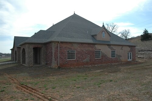
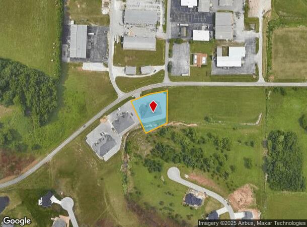
Property Record
840 W Guin Rd, Nixa, MO 65714


NEARBY LISTINGS FOR SALE OR LEASE
-
-
View all Nixa listings for sale on LoopNet.com
Property Detail
840 W Guin Rd
Springfield, MO
Tuscany Hills
05-0.7-35-001-001-001.004
LOT C-3 TUSCANY HILLS PH 2 REPLAT
Agriculturalland
Christian
X
Missouri
29043C0058D
c-3
2023
1.06 AC
2024
West Christian County
020202
Springfield
17,964 SF
DEMOGRAPHICS near 840 W Guin Rd
1 Mile
3 Mile
5 Mile
2024 Total Population
2,167
33,206
105,552
2029 Population
2,440
35,816
112,840
Pop Growth 2024-2029
+ 12.60%
+ 7.86%
+ 6.90%
Average Age
38
41
41
2024 Total Households
839
13,078
44,061
HH Growth 2024-2029
+ 12.75%
+ 7.91%
+ 6.72%
Median Household Inc
$64,252
$80,216
$67,035
Avg Household Size
2.60
2.50
2.30
2024 Avg HH Vehicles
2.00
2.00
2.00
Median Home Value
$218,904
$250,096
$227,325
Median Year Built
1993
1996
1993
Nearby Places
Map Layers
Map Styles
 Street
 Aerial
- Restaurants
- Banks
- Shops
- Fitness
- Groceries
PUBLIC TRANSPORTATION
AIRPORT
Springfield-Branson Ntl
DRIVE
WALK
Distance
Springfield-Branson Ntl
34 min
17.9 mi
Freight Ports
Tulsa Port of Inola
DRIVE
WALK
Distance
Tulsa Port of Inola
196 min
175.6 mi
Nearby Properties
Address
Land Use
TOTAL SIZE
Lot Size
Zoning
Address
Land Use
TOTAL SIZE
Lot Size
Zoning
140,147 SF
17.64 AC
INC
Address
Land Use
TOTAL SIZE
Lot Size
Zoning
86,566 SF
9.63 AC
INC
Address
Land Use
TOTAL SIZE
Lot Size
Zoning
26.20 AC
Address
Land Use
TOTAL SIZE
Lot Size
Zoning
310,792 SF
12.27 AC
Address
Land Use
TOTAL SIZE
Lot Size
Zoning
18.16 AC
Address
Land Use
TOTAL SIZE
Lot Size
Zoning
4.12 AC
INC
Address
Land Use
TOTAL SIZE
Lot Size
Zoning
5.59 AC
INC
Address
Land Use
TOTAL SIZE
Lot Size
Zoning
10,720 SF
9.71 AC
Address
Land Use
TOTAL SIZE
Lot Size
Zoning
21.59 AC
INC
Address
Land Use
TOTAL SIZE
Lot Size
Zoning
126,557 SF
4.62 AC
INC
Address
Land Use
TOTAL SIZE
Lot Size
Zoning
4.16 AC
INC
Address
Land Use
TOTAL SIZE
Lot Size
Zoning
125,218 SF
4.68 AC
INC
Address
Land Use
TOTAL SIZE
Lot Size
Zoning
30,049 SF
5.01 AC
Address
Land Use
TOTAL SIZE
Lot Size
Zoning
3,080 SF
24.20 AC
Address
Land Use
TOTAL SIZE
Lot Size
Zoning
19,682 SF
7.17 AC
Address
Land Use
TOTAL SIZE
Lot Size
Zoning
101,420 SF
4.01 AC
PAD
Address
Land Use
TOTAL SIZE
Lot Size
Zoning
1 AC
INC
Address
Land Use
TOTAL SIZE
Lot Size
Zoning
45,260 SF
2.80 AC
INC
Address
Land Use
TOTAL SIZE
Lot Size
Zoning
Address
Land Use
TOTAL SIZE
Lot Size
Zoning
107,194 SF
39.40 AC
Address
Land Use
TOTAL SIZE
Lot Size
Zoning
23,660 SF
10 AC
Address
Land Use
TOTAL SIZE
Lot Size
Zoning
57,547 SF
4.93 AC
INC
Address
Land Use
TOTAL SIZE
Lot Size
Zoning
71,436 SF
2.86 AC
INC
Address
Land Use
TOTAL SIZE
Lot Size
Zoning
13,836 SF
5.81 AC
Address
Land Use
TOTAL SIZE
Lot Size
Zoning
36,110 SF
7 AC
Address
Land Use
TOTAL SIZE
Lot Size
Zoning
2.61 AC
INC.
Address
Land Use
TOTAL SIZE
Lot Size
Zoning
51,498 SF
39.26 AC
Address
Land Use
TOTAL SIZE
Lot Size
Zoning
18,391 SF
1.78 AC
INC
Address
Land Use
TOTAL SIZE
Lot Size
Zoning
13.08 AC
INC
Address
Land Use
TOTAL SIZE
Lot Size
Zoning
1.44 AC
INC
The World's #1 Commercial Real Estate Marketplace
Connect with us
© 2026 CoStar Group
The information above has been obtained from sources believed reliable. While we do not doubt its accuracy we have not verified it and make no guarantee, warranty or representation about it. It is your responsibility to independently confirm its accuracy and completeness. Any projections, opinions, assumptions, or estimates used are for example only and do not represent the current or future performance of the property. The value of this transaction to you depends on tax and other factors which should be evaluated by your tax, financial, and legal advisors. You and your advisors should conduct a careful, independent investigation of the property to determine to your satisfaction the suitability of the property for your needs.