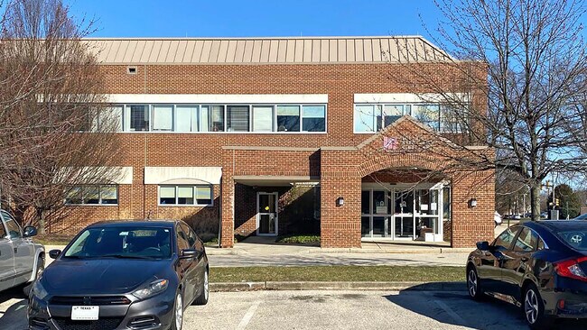
Property Record
5443 W Girard Ave, Philadelphia, PA 19131


Current Lease Availabilities
NEARBY LISTINGS FOR SALE OR LEASE
Property Detail
5443 W Girard Ave
Philadelphia-Camden-Wilmington, PA-NJ-DE-MD
Pennoni Assoc Inc
041088505
NEC 55TH ST
Parkingstructure
Philadelphia
X
Pennsylvania
42091C0410G
54
2024
0.23 AC
2026
Northeast Philadelphia
011200
Philadelphia
1,040 SF
DEMOGRAPHICS near 5443 W Girard Ave
1 Mile
3 Mile
5 Mile
2024 Total Population
35,774
258,877
524,942
2029 Population
34,271
246,711
504,657
Pop Growth 2024-2029
(4.20%)
(4.70%)
(3.86%)
Average Age
42
39
39
2024 Total Households
14,113
95,140
193,799
HH Growth 2024-2029
(4.50%)
(4.93%)
(4.03%)
Median Household Inc
$56,047
$58,967
$60,790
Avg Household Size
2.40
2.60
2.60
2024 Avg HH Vehicles
1.00
1.00
1.00
Median Home Value
$246,806
$223,587
$225,975
Median Year Built
1962
1957
1957
Nearby Places
Map Layers
Map Styles
 Street
 Aerial
- Restaurants
- Banks
- Shops
- Fitness
- Groceries
PUBLIC TRANSPORTATION
TRANSIT/SUBWAY
Girard Av & 54Th St (63rd-Girard to Richmond-Westmorelnd - SEPTA)
DRIVE
WALK
Distance
Girard Av & 54Th St (63rd-Girard to Richmond-Westmorelnd - SEPTA)
0 min
1 min
0.1 mi
Girard Av & 56Th St (63rd-Girard to Richmond-Westmorelnd - SEPTA)
DRIVE
WALK
Distance
Girard Av & 56Th St (63rd-Girard to Richmond-Westmorelnd - SEPTA)
0 min
3 min
0.2 mi
Girard Av & 57Th St (63rd-Girard to Richmond-Westmorelnd - SEPTA)
DRIVE
WALK
Distance
Girard Av & 57Th St (63rd-Girard to Richmond-Westmorelnd - SEPTA)
0 min
4 min
0.2 mi
Girard Av & 52Nd St (63rd-Girard to Richmond-Westmorelnd - SEPTA)
DRIVE
WALK
Distance
Girard Av & 52Nd St (63rd-Girard to Richmond-Westmorelnd - SEPTA)
0 min
4 min
0.2 mi
Girard Av & 51St St (63rd-Girard to Richmond-Westmorelnd - SEPTA)
DRIVE
WALK
Distance
Girard Av & 51St St (63rd-Girard to Richmond-Westmorelnd - SEPTA)
1 min
7 min
0.4 mi
COMMUTER RAIL
Wynnefield Avenue (R6 - Southeastern Pennsylvania Transportation Authority Regional Rail (SEPTA Regional Rail))
DRIVE
WALK
Distance
Wynnefield Avenue (R6 - Southeastern Pennsylvania Transportation Authority Regional Rail (SEPTA Regional Rail))
6 min
1.7 mi
Overbrook (R5 - Southeastern Pennsylvania Transportation Authority Regional Rail (SEPTA Regional Rail))
DRIVE
WALK
Distance
Overbrook (R5 - Southeastern Pennsylvania Transportation Authority Regional Rail (SEPTA Regional Rail))
5 min
2.0 mi
AIRPORT
Philadelphia International
DRIVE
WALK
Distance
Philadelphia International
22 min
9.1 mi
Freight Ports
South Jersey Port
DRIVE
WALK
Distance
South Jersey Port
17 min
8.3 mi
Nearby Properties
Address
Land Use
TOTAL SIZE
Lot Size
Zoning
Address
Land Use
TOTAL SIZE
Lot Size
Zoning
1,076,400 SF
5 AC
CMX4
Address
Land Use
TOTAL SIZE
Lot Size
Zoning
26,690 SF
500 AC
SPINS
Address
Land Use
TOTAL SIZE
Lot Size
Zoning
319,590 SF
0.87 AC
I2
Address
Land Use
TOTAL SIZE
Lot Size
Zoning
1,179,072 SF
8.90 AC
RM4
Address
Land Use
TOTAL SIZE
Lot Size
Zoning
782,208 SF
0.68 AC
CMX5
Address
Land Use
TOTAL SIZE
Lot Size
Zoning
500,165 SF
2.16 AC
SPPOA
Address
Land Use
TOTAL SIZE
Lot Size
Zoning
696,920 SF
10.55 AC
SPINS
Address
Land Use
TOTAL SIZE
Lot Size
Zoning
700,000 SF
7.88 AC
CMX5
Address
Land Use
TOTAL SIZE
Lot Size
Zoning
391,440 SF
1.72 AC
SPINS
Address
Land Use
TOTAL SIZE
Lot Size
Zoning
600,523 SF
1.85 AC
CMX4
Address
Land Use
TOTAL SIZE
Lot Size
Zoning
385,000 SF
2.49 AC
SPINS
Address
Land Use
TOTAL SIZE
Lot Size
Zoning
376,874 SF
3.14 AC
SPINS
Address
Land Use
TOTAL SIZE
Lot Size
Zoning
375,500 SF
1.40 AC
CMX5
Address
Land Use
TOTAL SIZE
Lot Size
Zoning
428,400 SF
1.02 AC
CMX4
Address
Land Use
TOTAL SIZE
Lot Size
Zoning
373,040 SF
4.17 AC
SPINS
Address
Land Use
TOTAL SIZE
Lot Size
Zoning
400,000 SF
3.32 AC
CMX5
Address
Land Use
TOTAL SIZE
Lot Size
Zoning
391,885 SF
7.15 AC
RM4
Address
Land Use
TOTAL SIZE
Lot Size
Zoning
1,588,163 SF
7.28 AC
SPINS
Address
Land Use
TOTAL SIZE
Lot Size
Zoning
303,750 SF
1.36 AC
SPINS
Address
Land Use
TOTAL SIZE
Lot Size
Zoning
552,275 SF
1 AC
CMX3
Address
Land Use
TOTAL SIZE
Lot Size
Zoning
3.02 AC
RMX3
Address
Land Use
TOTAL SIZE
Lot Size
Zoning
239,760 SF
5.51 AC
SPINS
Address
Land Use
TOTAL SIZE
Lot Size
Zoning
2,178,860 SF
48.65 AC
R3
Address
Land Use
TOTAL SIZE
Lot Size
Zoning
473,400 SF
0.86 AC
CMX4
Address
Land Use
TOTAL SIZE
Lot Size
Zoning
Address
Land Use
TOTAL SIZE
Lot Size
Zoning
698,358 SF
16.79 AC
SPINS
Address
Land Use
TOTAL SIZE
Lot Size
Zoning
261,350 SF
1.11 AC
CMX5
Address
Land Use
TOTAL SIZE
Lot Size
Zoning
279,420 SF
1.21 AC
SPINS
Address
Land Use
TOTAL SIZE
Lot Size
Zoning
396,788 SF
1.62 AC
CMX5
Address
Land Use
TOTAL SIZE
Lot Size
Zoning
The World's #1 Commercial Real Estate Marketplace
Connect with us
© 2025 CoStar Group
The information above has been obtained from sources believed reliable. While we do not doubt its accuracy we have not verified it and make no guarantee, warranty or representation about it. It is your responsibility to independently confirm its accuracy and completeness. Any projections, opinions, assumptions, or estimates used are for example only and do not represent the current or future performance of the property. The value of this transaction to you depends on tax and other factors which should be evaluated by your tax, financial, and legal advisors. You and your advisors should conduct a careful, independent investigation of the property to determine to your satisfaction the suitability of the property for your needs.