Property Record
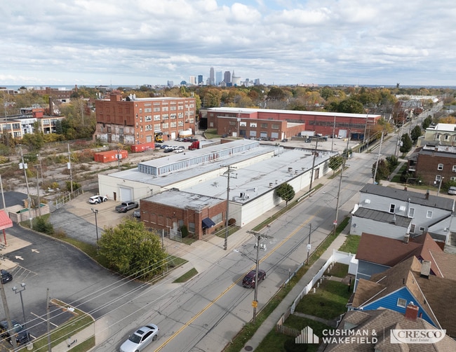
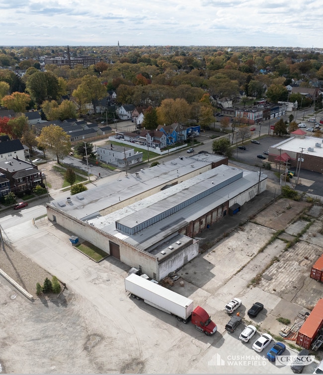
8400 Madison Ave, Cleveland, OH 44102
This Property Is For Sale
NEARBY LISTINGS FOR SALE OR LEASE
Property Detail
8400 Madison Ave
Cleveland-Elyria, OH
James F Rhodes Subdivision
002-21-046
29 EP 530 FT E OF W 85 ST
Publicstorage
Cuyahoga
X
Ohio
39035C0176F
29
2024
0.50 AC
2024
Downtown West
101800
Cleveland
14,573 SF
DEMOGRAPHICS near 8400 Madison Ave
1 Mile
3 Mile
5 Mile
2024 Total Population
24,011
136,996
276,157
2029 Population
23,308
132,874
268,326
Pop Growth 2024-2029
(2.93%)
(3.01%)
(2.84%)
Average Age
37
38
38
2024 Total Households
10,648
64,178
127,991
HH Growth 2024-2029
(3.03%)
(2.95%)
(2.78%)
Median Household Inc
$33,005
$44,677
$47,515
Avg Household Size
2.10
2.00
2.00
2024 Avg HH Vehicles
1.00
1.00
1.00
Median Home Value
$119,219
$132,470
$138,964
Median Year Built
1946
1947
1948
Nearby Places
Map Layers
Map Styles
 Street
 Aerial
- Restaurants
- Banks
- Shops
- Fitness
- Groceries
PUBLIC TRANSPORTATION
TRANSIT/SUBWAY
West 65 - Lorain (Red Line - Greater Cleveland Regional Transit Authority Rapid Transit (The Rapid))
DRIVE
WALK
Distance
West 65 - Lorain (Red Line - Greater Cleveland Regional Transit Authority Rapid Transit (The Rapid))
3 min
13 min
0.7 mi
West Boulevard - Cudell (Red Line - Greater Cleveland Regional Transit Authority Rapid Transit (The Rapid))
DRIVE
WALK
Distance
West Boulevard - Cudell (Red Line - Greater Cleveland Regional Transit Authority Rapid Transit (The Rapid))
2 min
15 min
0.8 mi
COMMUTER RAIL
Cleveland Lakefront Station (Blue Line - Greater Cleveland Regional Transit Authority Rapid Transit (The Rapid), Green Line - Greater Cleveland Regional Transit Authority Rapid Transit (The Rapid))
DRIVE
WALK
Distance
Cleveland Lakefront Station (Blue Line - Greater Cleveland Regional Transit Authority Rapid Transit (The Rapid), Green Line - Greater Cleveland Regional Transit Authority Rapid Transit (The Rapid))
13 min
4.8 mi
AIRPORT
Cleveland-Hopkins International
DRIVE
WALK
Distance
Cleveland-Hopkins International
21 min
9.3 mi
Nearby Properties
Address
Land Use
TOTAL SIZE
Lot Size
Zoning
Address
Land Use
TOTAL SIZE
Lot Size
Zoning
3,491,901 SF
34.32 AC
Address
Land Use
TOTAL SIZE
Lot Size
Zoning
753,970 SF
9.31 AC
GR
Address
Land Use
TOTAL SIZE
Lot Size
Zoning
1,570,958 SF
1.33 AC
GR
Address
Land Use
TOTAL SIZE
Lot Size
Zoning
710,780 SF
4.33 AC
GR
Address
Land Use
TOTAL SIZE
Lot Size
Zoning
5,100 SF
9.41 AC
GI
Address
Land Use
TOTAL SIZE
Lot Size
Zoning
652,455 SF
2.04 AC
GR
Address
Land Use
TOTAL SIZE
Lot Size
Zoning
1,130,924 SF
4.02 AC
SI
Address
Land Use
TOTAL SIZE
Lot Size
Zoning
299,515 SF
1.30 AC
GR
Address
Land Use
TOTAL SIZE
Lot Size
Zoning
3.23 AC
LLR
Address
Land Use
TOTAL SIZE
Lot Size
Zoning
2.74 AC
Address
Land Use
TOTAL SIZE
Lot Size
Zoning
70.02 AC
GI
Address
Land Use
TOTAL SIZE
Lot Size
Zoning
758,394 SF
2.25 AC
GR
Address
Land Use
TOTAL SIZE
Lot Size
Zoning
493,911 SF
1.88 AC
LLR
Address
Land Use
TOTAL SIZE
Lot Size
Zoning
257,857 SF
8.03 AC
GR
Address
Land Use
TOTAL SIZE
Lot Size
Zoning
1.53 AC
LLR
Address
Land Use
TOTAL SIZE
Lot Size
Zoning
299,507 SF
2.14 AC
LR
Address
Land Use
TOTAL SIZE
Lot Size
Zoning
2.83 AC
LLR
Address
Land Use
TOTAL SIZE
Lot Size
Zoning
1.61 AC
BOR
Address
Land Use
TOTAL SIZE
Lot Size
Zoning
635,481 SF
1.51 AC
SI
Address
Land Use
TOTAL SIZE
Lot Size
Zoning
518,244 SF
21.80 AC
Address
Land Use
TOTAL SIZE
Lot Size
Zoning
293,197 SF
1.54 AC
SI
Address
Land Use
TOTAL SIZE
Lot Size
Zoning
300,000 SF
2.07 AC
Address
Land Use
TOTAL SIZE
Lot Size
Zoning
317,996 SF
0.40 AC
SI
Address
Land Use
TOTAL SIZE
Lot Size
Zoning
391,575 SF
2.21 AC
SI
Address
Land Use
TOTAL SIZE
Lot Size
Zoning
164,294 SF
13.81 AC
GI
Address
Land Use
TOTAL SIZE
Lot Size
Zoning
320,334 SF
4 AC
GR
Address
Land Use
TOTAL SIZE
Lot Size
Zoning
200,874 SF
3.30 AC
LR
Address
Land Use
TOTAL SIZE
Lot Size
Zoning
227,787 SF
3.40 AC
LR
Address
Land Use
TOTAL SIZE
Lot Size
Zoning
352,895 SF
2.70 AC
LLR
Address
Land Use
TOTAL SIZE
Lot Size
Zoning
242,515 SF
1.01 AC
The World's #1 Commercial Real Estate Marketplace
Connect with us
© 2025 CoStar Group
The information above has been obtained from sources believed reliable. While we do not doubt its accuracy we have not verified it and make no guarantee, warranty or representation about it. It is your responsibility to independently confirm its accuracy and completeness. Any projections, opinions, assumptions, or estimates used are for example only and do not represent the current or future performance of the property. The value of this transaction to you depends on tax and other factors which should be evaluated by your tax, financial, and legal advisors. You and your advisors should conduct a careful, independent investigation of the property to determine to your satisfaction the suitability of the property for your needs.