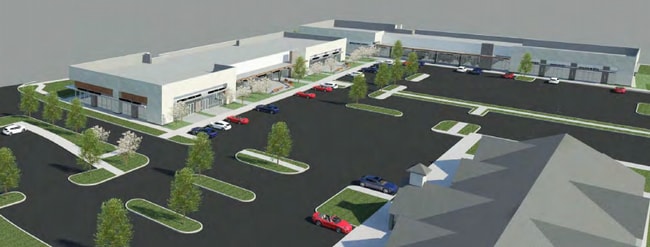
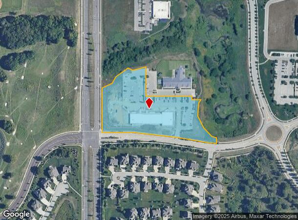
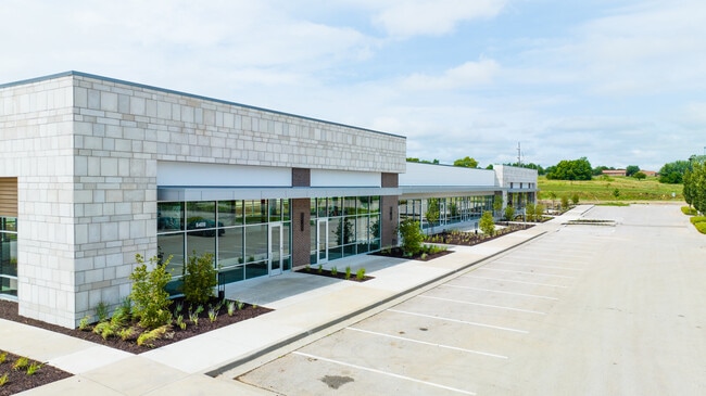
Property Record
8400 W 165Th St, Overland Park, KS 66223
NEARBY LISTINGS FOR SALE OR LEASE
Property Detail
8400 W 165Th St
Kansas City, MO-KS
Bluhawk Plaza South First Plat
NP04950000-0003
BLUHAWK PLAZA SOUTH SECOND PLAT LT 3
Officebuilding
Johnson
X
Kansas
20091C0113G
3
2024
4.34 AC
2024
South Johnson County
053418
Kansas City
17,640 SF
DEMOGRAPHICS near 8400 W 165Th St
1 Mile
3 Mile
5 Mile
2024 Total Population
5,198
49,115
127,951
2029 Population
5,413
51,618
133,857
Pop Growth 2024-2029
+ 4.14%
+ 5.10%
+ 4.62%
Average Age
36
38
39
2024 Total Households
1,656
16,076
45,836
HH Growth 2024-2029
+ 4.35%
+ 5.11%
+ 4.78%
Median Household Inc
$173,757
$159,990
$136,508
Avg Household Size
3.10
3.00
2.70
2024 Avg HH Vehicles
2.00
2.00
2.00
Median Home Value
$546,512
$485,358
$450,985
Median Year Built
2010
2001
2000
Nearby Places
- Restaurants
- Banks
- Shops
- Fitness
- Groceries
SALE & LEASE HISTORY
LISTING DATE
SALE/LEASE

Oct 12, 2021
For Lease
Nearby Properties
Address
Land Use
TOTAL SIZE
Lot Size
Zoning
Address
Land Use
TOTAL SIZE
Lot Size
Zoning
195,983 SF
20.88 AC
CP-2
Address
Land Use
TOTAL SIZE
Lot Size
Zoning
320,892 SF
74.58 AC
R-1
Address
Land Use
TOTAL SIZE
Lot Size
Zoning
199,247 SF
50.19 AC
R-1
Address
Land Use
TOTAL SIZE
Lot Size
Zoning
316,630 SF
62.18 AC
RE
Address
Land Use
TOTAL SIZE
Lot Size
Zoning
239,520 SF
35.28 AC
R-1BJ
Address
Land Use
TOTAL SIZE
Lot Size
Zoning
143,207 SF
16.19 AC
R-1
Address
Land Use
TOTAL SIZE
Lot Size
Zoning
254,535 SF
11.97 AC
RN1
Address
Land Use
TOTAL SIZE
Lot Size
Zoning
122,491 SF
19.30 AC
R-1
Address
Land Use
TOTAL SIZE
Lot Size
Zoning
185,906 SF
34.09 AC
R-1
Address
Land Use
TOTAL SIZE
Lot Size
Zoning
119,299 SF
43.14 AC
RE
Address
Land Use
TOTAL SIZE
Lot Size
Zoning
84,719 SF
16.12 AC
RURJ
Address
Land Use
TOTAL SIZE
Lot Size
Zoning
76,942 SF
15.10 AC
R-1
Address
Land Use
TOTAL SIZE
Lot Size
Zoning
86,095 SF
16.95 AC
R-1
Address
Land Use
TOTAL SIZE
Lot Size
Zoning
69,077 SF
17.90 AC
R-1
Address
Land Use
TOTAL SIZE
Lot Size
Zoning
115,263 SF
23.66 AC
R-1
Address
Land Use
TOTAL SIZE
Lot Size
Zoning
65,388 SF
19.09 AC
RURJ
Address
Land Use
TOTAL SIZE
Lot Size
Zoning
59,770 SF
8.88 AC
CP-2
Address
Land Use
TOTAL SIZE
Lot Size
Zoning
56,287 SF
7.88 AC
R-1
Address
Land Use
TOTAL SIZE
Lot Size
Zoning
81,096 SF
121.93 AC
AG
Address
Land Use
TOTAL SIZE
Lot Size
Zoning
69,455 SF
18.26 AC
RE
Address
Land Use
TOTAL SIZE
Lot Size
Zoning
67,523 SF
11.95 AC
R-1
Address
Land Use
TOTAL SIZE
Lot Size
Zoning
69,540 SF
6.87 AC
R-1
Address
Land Use
TOTAL SIZE
Lot Size
Zoning
31,890 SF
2.38 AC
R-1
Address
Land Use
TOTAL SIZE
Lot Size
Zoning
54,585 SF
10.52 AC
RRJ
Address
Land Use
TOTAL SIZE
Lot Size
Zoning
64,529 SF
11.46 AC
R-1
Address
Land Use
TOTAL SIZE
Lot Size
Zoning
50,835 SF
5.80 AC
R-1BJ
Address
Land Use
TOTAL SIZE
Lot Size
Zoning
32,158 SF
3.07 AC
RRJ
Address
Land Use
TOTAL SIZE
Lot Size
Zoning
36,711 SF
96.57 AC
RURJ
Address
Land Use
TOTAL SIZE
Lot Size
Zoning
73,251 SF
29.96 AC
RP-3
Address
Land Use
TOTAL SIZE
Lot Size
Zoning
22,962 SF
5.37 AC
CP-2
The World's #1 Commercial Real Estate Marketplace
Connect with us
© 2025 CoStar Group
The information above has been obtained from sources believed reliable. While we do not doubt its accuracy we have not verified it and make no guarantee, warranty or representation about it. It is your responsibility to independently confirm its accuracy and completeness. Any projections, opinions, assumptions, or estimates used are for example only and do not represent the current or future performance of the property. The value of this transaction to you depends on tax and other factors which should be evaluated by your tax, financial, and legal advisors. You and your advisors should conduct a careful, independent investigation of the property to determine to your satisfaction the suitability of the property for your needs.