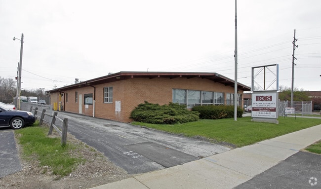
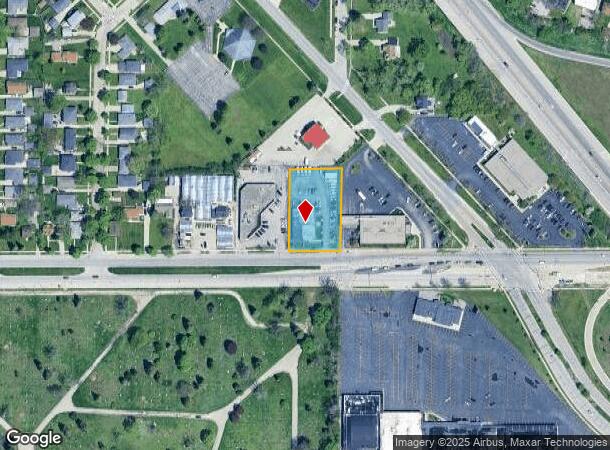
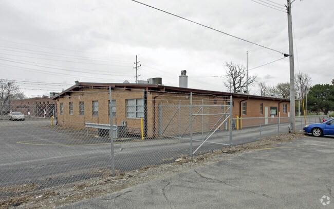
Property Record
8400 W Silver Spring Dr, Milwaukee, WI 53225

This Property Is For Sale
NEARBY LISTINGS FOR SALE OR LEASE
Property Detail
8400 W Silver Spring Dr
177-9999-111-X
LANDS IN SW 1/4 SEC 28-8-21 COM E LI & 60' N OF SE COR SD 1/4 SEC -TH W 147.555' -TH N 235.11' -TH E 147.555' -TH S 235.11' TO BEG
Officebuilding
Milwaukee
X
Wisconsin
55133C0250G
0.80 AC
2024
Milwaukee NW
2024
Milwaukee/Madison
001500
Milwaukee-Waukesha-West Allis, WI
5,104 SF
DEMOGRAPHICS near 8400 W Silver Spring Dr
1 Mile
3 Mile
5 Mile
2024 Total Population
18,966
120,756
293,804
2029 Population
18,651
118,609
289,640
Pop Growth 2024-2029
(1.66%)
(1.78%)
(1.42%)
Average Age
33
36
37
2024 Total Households
6,793
46,413
117,581
HH Growth 2024-2029
(1.78%)
(1.82%)
(1.54%)
Median Household Inc
$42,284
$47,918
$52,446
Avg Household Size
2.70
2.50
2.40
2024 Avg HH Vehicles
1.00
1.00
1.00
Median Home Value
$118,992
$142,867
$177,830
Median Year Built
1959
1958
1956
Nearby Places
Map Layers
Map Styles
 Street
 Aerial
- Restaurants
- Banks
- Shops
- Fitness
- Groceries
PUBLIC TRANSPORTATION
COMMUTER RAIL
Milwaukee (Empire Builder - Amtrak)
DRIVE
WALK
Distance
Milwaukee (Empire Builder - Amtrak)
20 min
9.9 mi
AIRPORT
General Mitchell International
DRIVE
WALK
Distance
General Mitchell International
32 min
15.0 mi
Freight Ports
Port Milwaukee
DRIVE
WALK
Distance
Port Milwaukee
24 min
10.9 mi
Nearby Properties
Address
Land Use
TOTAL SIZE
Lot Size
Zoning
Address
Land Use
TOTAL SIZE
Lot Size
Zoning
33.49 AC
TL
Address
Land Use
TOTAL SIZE
Lot Size
Zoning
0.71 AC
RM2
Address
Land Use
TOTAL SIZE
Lot Size
Zoning
8.03 AC
RM1
Address
Land Use
TOTAL SIZE
Lot Size
Zoning
0.71 AC
RM2
Address
Land Use
TOTAL SIZE
Lot Size
Zoning
197,426 SF
26.34 AC
PD
Address
Land Use
TOTAL SIZE
Lot Size
Zoning
206,529 SF
7.88 AC
PD
Address
Land Use
TOTAL SIZE
Lot Size
Zoning
298,666 SF
5.09 AC
PD
Address
Land Use
TOTAL SIZE
Lot Size
Zoning
21.66 AC
M2
Address
Land Use
TOTAL SIZE
Lot Size
Zoning
326,619 SF
30.69 AC
PD
Address
Land Use
TOTAL SIZE
Lot Size
Zoning
12.49 AC
TL
Address
Land Use
TOTAL SIZE
Lot Size
Zoning
12.48 AC
IL1
Address
Land Use
TOTAL SIZE
Lot Size
Zoning
104,365 SF
9.85 AC
PD
Address
Land Use
TOTAL SIZE
Lot Size
Zoning
17.84 AC
TL
Address
Land Use
TOTAL SIZE
Lot Size
Zoning
221,548 SF
11.80 AC
PD
Address
Land Use
TOTAL SIZE
Lot Size
Zoning
42.07 AC
IL1
Address
Land Use
TOTAL SIZE
Lot Size
Zoning
169,550 SF
12.04 AC
RB2
Address
Land Use
TOTAL SIZE
Lot Size
Zoning
18.54 AC
RS6
Address
Land Use
TOTAL SIZE
Lot Size
Zoning
28.28 AC
M2
Address
Land Use
TOTAL SIZE
Lot Size
Zoning
17.91 AC
RS5
Address
Land Use
TOTAL SIZE
Lot Size
Zoning
333,971 SF
16.93 AC
IL1
Address
Land Use
TOTAL SIZE
Lot Size
Zoning
166,245 SF
55 AC
PD
Address
Land Use
TOTAL SIZE
Lot Size
Zoning
28.12 AC
RM1
Address
Land Use
TOTAL SIZE
Lot Size
Zoning
23.38 AC
RS6
Address
Land Use
TOTAL SIZE
Lot Size
Zoning
163,539 SF
7.17 AC
PUD
Address
Land Use
TOTAL SIZE
Lot Size
Zoning
49.03 AC
PK
Address
Land Use
TOTAL SIZE
Lot Size
Zoning
88,259 SF
14.70 AC
PD
Address
Land Use
TOTAL SIZE
Lot Size
Zoning
9.94 AC
IL1
Address
Land Use
TOTAL SIZE
Lot Size
Zoning
1.40 AC
RM1
Address
Land Use
TOTAL SIZE
Lot Size
Zoning
92,303 SF
19.02 AC
PD
Address
Land Use
TOTAL SIZE
Lot Size
Zoning
118,520 SF
7.69 AC
RM1
The World's #1 Commercial Real Estate Marketplace
Connect with us
© 2025 CoStar Group
The information above has been obtained from sources believed reliable. While we do not doubt its accuracy we have not verified it and make no guarantee, warranty or representation about it. It is your responsibility to independently confirm its accuracy and completeness. Any projections, opinions, assumptions, or estimates used are for example only and do not represent the current or future performance of the property. The value of this transaction to you depends on tax and other factors which should be evaluated by your tax, financial, and legal advisors. You and your advisors should conduct a careful, independent investigation of the property to determine to your satisfaction the suitability of the property for your needs.