Property Record
8405 Blackjack Rd, Mount Vernon, OH 43050

Property Detail
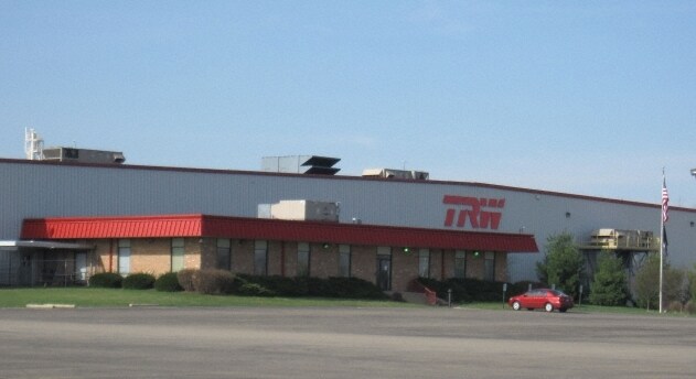
8405 Blackjack Rd
66-01058.000
13 6 4 S CENT PT 20 22.371AC
Heavymanufacturing
Knox
B and X Area of moderate flood hazard, usually the area between the limits of the 100-year and 500-year floods.
Ohio
2025
22.37 AC
2025
Other Market Areas
007600
Mount Vernon, OH
214,257 SF
NEARBY LISTINGS FOR SALE OR LEASE
DEMOGRAPHICS near 8405 Blackjack Rd
1 mile
3 mile
5 mile
2025 Total Population
660
13,266
26,014
2030 Population
667
13,462
26,403
Pop Growth 2025-2030
+ 1.06%
+ 1.48%
+ 1.50%
Average Age
44
40
41
2025 Total Households
282
5,115
10,342
HH Growth 2025-2030
+ 1.06%
+ 1.51%
+ 1.55%
Median Household Inc
$90,524
$62,636
$61,109
Avg Household Size
2.30
2.40
2.30
2025 Avg HH Vehicles
2.00
2.00
2.00
Median Home Value
$207,143
$185,898
$196,419
Median Year Built
1970
1951
1962
Nearby Places
Map Layers
Map Styles
 Street
 Aerial
Layers
 Traffic
 Biking
Places
Listings with unknown addresses are not visible on the map
- Restaurants
- Banks
- Shops
- Fitness
- Groceries
PUBLIC TRANSPORTATION
AIRPORT
John Glenn Columbus International
Drive
Walk
Distance
John Glenn Columbus International
57 min
41.9 mi
Nearby Properties
Address
Land Use
TOTAL SIZE
Lot Size
Zoning
Address
Land Use
TOTAL SIZE
Lot Size
Zoning
6,856 SF
106.31 AC
Address
Land Use
TOTAL SIZE
Lot Size
Zoning
118,756 SF
80 AC
Address
Land Use
TOTAL SIZE
Lot Size
Zoning
4,238 SF
11.38 AC
Address
Land Use
TOTAL SIZE
Lot Size
Zoning
Address
Land Use
TOTAL SIZE
Lot Size
Zoning
62,682 SF
4.10 AC
Address
Land Use
TOTAL SIZE
Lot Size
Zoning
120,513 SF
22.50 AC
Address
Land Use
TOTAL SIZE
Lot Size
Zoning
Address
Land Use
TOTAL SIZE
Lot Size
Zoning
239,625 SF
27.29 AC
Address
Land Use
TOTAL SIZE
Lot Size
Zoning
56,768 SF
62.58 AC
Address
Land Use
TOTAL SIZE
Lot Size
Zoning
281,700 SF
6.72 AC
Address
Land Use
TOTAL SIZE
Lot Size
Zoning
28,872 SF
0.14 AC
Address
Land Use
TOTAL SIZE
Lot Size
Zoning
65,802 SF
1.03 AC
Address
Land Use
TOTAL SIZE
Lot Size
Zoning
27,708 SF
5.84 AC
Address
Land Use
TOTAL SIZE
Lot Size
Zoning
21,399 SF
0.25 AC
Address
Land Use
TOTAL SIZE
Lot Size
Zoning
271,356 SF
9.63 AC
Address
Land Use
TOTAL SIZE
Lot Size
Zoning
48,821 SF
0.20 AC
Address
Land Use
TOTAL SIZE
Lot Size
Zoning
Address
Land Use
TOTAL SIZE
Lot Size
Zoning
21,712 SF
0.13 AC
Address
Land Use
TOTAL SIZE
Lot Size
Zoning
Address
Land Use
TOTAL SIZE
Lot Size
Zoning
96,000 SF
18.09 AC
Address
Land Use
TOTAL SIZE
Lot Size
Zoning
32,238 SF
33.17 AC
Address
Land Use
TOTAL SIZE
Lot Size
Zoning
69,600 SF
5.40 AC
Address
Land Use
TOTAL SIZE
Lot Size
Zoning
26,496 SF
0.21 AC
Address
Land Use
TOTAL SIZE
Lot Size
Zoning
63,750 SF
5.79 AC
Address
Land Use
TOTAL SIZE
Lot Size
Zoning
2,052 SF
59.12 AC
Address
Land Use
TOTAL SIZE
Lot Size
Zoning
Address
Land Use
TOTAL SIZE
Lot Size
Zoning
122,935 SF
7.75 AC
Address
Land Use
TOTAL SIZE
Lot Size
Zoning
7,521 SF
94.90 AC
Address
Land Use
TOTAL SIZE
Lot Size
Zoning
19,556 SF
0.20 AC
The World's #1 Commercial Real Estate Marketplace
Connect with us
© 2026 CoStar Group
The information above has been obtained from sources believed reliable. While we do not doubt its accuracy we have not verified it and make no guarantee, warranty or representation about it. It is your responsibility to independently confirm its accuracy and completeness. Any projections, opinions, assumptions, or estimates used are for example only and do not represent the current or future performance of the property. The value of this transaction to you depends on tax and other factors which should be evaluated by your tax, financial, and legal advisors. You and your advisors should conduct a careful, independent investigation of the property to determine to your satisfaction the suitability of the property for your needs.