Property Record
841 3Rd St, Henderson, KY 42420

Property Detail
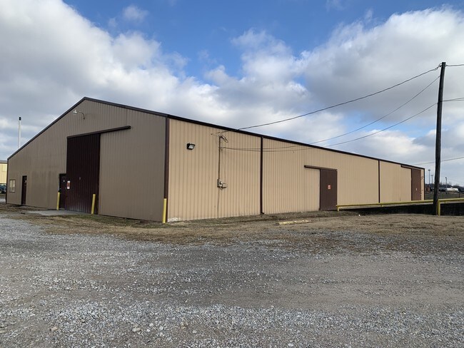
841 3Rd St
3-9-4-3
WAREHOUSE
Warehouse
Henderson
A Areas with a 1% annual chance of flooding and a 26% chance of flooding over the life of a 30-year mortgage.
Kentucky
2025
1.13 AC
2025
Henderson County
020200
Evansville
7,374 SF
Henderson, KY
NEARBY LISTINGS FOR SALE OR LEASE
DEMOGRAPHICS near 841 3Rd St
1 mile
3 mile
5 mile
2025 Total Population
7,867
26,539
31,388
2030 Population
7,933
26,509
31,316
Pop Growth 2025-2030
+ 0.84%
(0.11%)
(0.23%)
Average Age
40
41
41
2025 Total Households
3,379
11,339
13,258
HH Growth 2025-2030
+ 0.80%
(0.12%)
(0.24%)
Median Household Inc
$37,440
$46,636
$49,834
Avg Household Size
2.20
2.20
2.30
2025 Avg HH Vehicles
1.00
2.00
2.00
Median Home Value
$93,713
$164,756
$177,264
Median Year Built
1954
1973
1974
Nearby Places
Map Layers
Map Styles
 Street
 Aerial
Transit
 Traffic
 Biking
Places
Listings with unknown addresses are not visible on the map
- Restaurants
- Banks
- Shops
- Fitness
- Groceries
PUBLIC TRANSPORTATION
AIRPORT
Evansville Regional
Drive
Walk
Distance
Evansville Regional
28 min
15.5 mi
Freight Ports
Port of Toledo
Drive
Walk
Distance
Port of Toledo
473 min
405.2 mi
SALE & LEASE HISTORY
LISTING DATE
SALE/LEASE

Jan 06, 2020
For Sale
Jan 03, 2020
For Lease
Nearby Properties
Address
Land Use
TOTAL SIZE
Lot Size
Zoning
Address
Land Use
TOTAL SIZE
Lot Size
Zoning
321,460 SF
75.59 AC
Address
Land Use
TOTAL SIZE
Lot Size
Zoning
524,000 SF
20.76 AC
Address
Land Use
TOTAL SIZE
Lot Size
Zoning
11.19 AC
Address
Land Use
TOTAL SIZE
Lot Size
Zoning
110,917 SF
25.76 AC
Address
Land Use
TOTAL SIZE
Lot Size
Zoning
65,597 SF
23.18 AC
Address
Land Use
TOTAL SIZE
Lot Size
Zoning
16.35 AC
Address
Land Use
TOTAL SIZE
Lot Size
Zoning
56,178 SF
7.19 AC
Address
Land Use
TOTAL SIZE
Lot Size
Zoning
20.87 AC
Address
Land Use
TOTAL SIZE
Lot Size
Zoning
53,803 SF
4 AC
Address
Land Use
TOTAL SIZE
Lot Size
Zoning
4.90 AC
Address
Land Use
TOTAL SIZE
Lot Size
Zoning
25.17 AC
COMMERCIAL
Address
Land Use
TOTAL SIZE
Lot Size
Zoning
Address
Land Use
TOTAL SIZE
Lot Size
Zoning
70.09 AC
Address
Land Use
TOTAL SIZE
Lot Size
Zoning
Address
Land Use
TOTAL SIZE
Lot Size
Zoning
Address
Land Use
TOTAL SIZE
Lot Size
Zoning
110,917 SF
2.90 AC
Address
Land Use
TOTAL SIZE
Lot Size
Zoning
126.50 AC
Address
Land Use
TOTAL SIZE
Lot Size
Zoning
21,336 SF
0.36 AC
Address
Land Use
TOTAL SIZE
Lot Size
Zoning
7,600 SF
13.85 AC
Address
Land Use
TOTAL SIZE
Lot Size
Zoning
83,956 SF
8.85 AC
Address
Land Use
TOTAL SIZE
Lot Size
Zoning
32.38 AC
Address
Land Use
TOTAL SIZE
Lot Size
Zoning
13.71 AC
COMMERCIAL
Address
Land Use
TOTAL SIZE
Lot Size
Zoning
12,996 SF
1.97 AC
COMMERCIAL
Address
Land Use
TOTAL SIZE
Lot Size
Zoning
5,472 SF
10.66 AC
Address
Land Use
TOTAL SIZE
Lot Size
Zoning
10.31 AC
Address
Land Use
TOTAL SIZE
Lot Size
Zoning
Address
Land Use
TOTAL SIZE
Lot Size
Zoning
89,082 SF
4.39 AC
Address
Land Use
TOTAL SIZE
Lot Size
Zoning
21,500 SF
1.25 AC
COMMERCIAL
Address
Land Use
TOTAL SIZE
Lot Size
Zoning
15,872 SF
12.11 AC
Address
Land Use
TOTAL SIZE
Lot Size
Zoning
29,896 SF
1.32 AC
The World's #1 Commercial Real Estate Marketplace
Connect with us
© 2026 CoStar Group
The information above has been obtained from sources believed reliable. While we do not doubt its accuracy we have not verified it and make no guarantee, warranty or representation about it. It is your responsibility to independently confirm its accuracy and completeness. Any projections, opinions, assumptions, or estimates used are for example only and do not represent the current or future performance of the property. The value of this transaction to you depends on tax and other factors which should be evaluated by your tax, financial, and legal advisors. You and your advisors should conduct a careful, independent investigation of the property to determine to your satisfaction the suitability of the property for your needs.