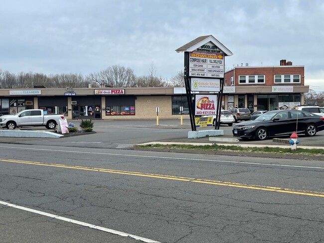
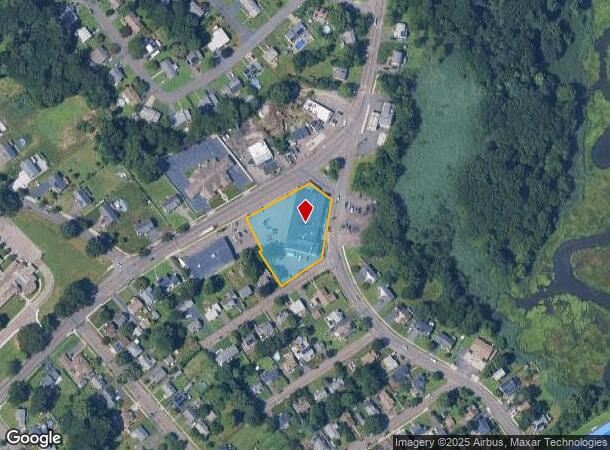
Property Record
841 Jones Hill Rd, West Haven, CT 06516


Current Lease Availabilities
NEARBY LISTINGS FOR SALE OR LEASE
Property Detail
841 Jones Hill Rd
Departmentstore
New Haven
AE
Connecticut
09009C0439J
1.08 AC
2025
West Haven
2025
Westchester/So Connecticut
154800
New Haven-Milford, CT
31,150 SF
WHAV-000019-000073
DEMOGRAPHICS near 841 Jones Hill Rd
1 Mile
3 Mile
5 Mile
2024 Total Population
11,750
69,074
192,114
2029 Population
11,588
68,179
190,508
Pop Growth 2024-2029
(1.38%)
(1.30%)
(0.84%)
Average Age
44
40
38
2024 Total Households
4,999
26,371
75,191
HH Growth 2024-2029
(1.42%)
(1.34%)
(0.82%)
Median Household Inc
$84,037
$69,923
$65,231
Avg Household Size
2.30
2.40
2.30
2024 Avg HH Vehicles
2.00
2.00
1.00
Median Home Value
$235,072
$244,113
$272,596
Median Year Built
1958
1959
1957
Nearby Places
Map Layers
Map Styles
 Street
 Aerial
- Restaurants
- Banks
- Shops
- Fitness
- Groceries
PUBLIC TRANSPORTATION
COMMUTER RAIL
New Haven-Union Station (New Haven Line - Metro-North Commuter Railroad Company (Metro-North))
DRIVE
WALK
Distance
New Haven-Union Station (New Haven Line - Metro-North Commuter Railroad Company (Metro-North))
11 min
5.7 mi
Union Station (Shore Line East - Shore Line East)
DRIVE
WALK
Distance
Union Station (Shore Line East - Shore Line East)
11 min
5.7 mi
AIRPORT
Westchester County
DRIVE
WALK
Distance
Westchester County
65 min
47.8 mi
Nearby Properties
Address
Land Use
TOTAL SIZE
Lot Size
Zoning
Address
Land Use
TOTAL SIZE
Lot Size
Zoning
56,359 SF
17.09 AC
RCPD
Address
Land Use
TOTAL SIZE
Lot Size
Zoning
50.14 AC
PRD
Address
Land Use
TOTAL SIZE
Lot Size
Zoning
81,870 SF
3.86 AC
RM2
Address
Land Use
TOTAL SIZE
Lot Size
Zoning
42.52 AC
PF
Address
Land Use
TOTAL SIZE
Lot Size
Zoning
287,844 SF
2.11 AC
IL
Address
Land Use
TOTAL SIZE
Lot Size
Zoning
29.78 AC
PRD
Address
Land Use
TOTAL SIZE
Lot Size
Zoning
76,945 SF
8.52 AC
RM2
Address
Land Use
TOTAL SIZE
Lot Size
Zoning
35.05 AC
LI-2
Address
Land Use
TOTAL SIZE
Lot Size
Zoning
214,516 SF
35.88 AC
RA
Address
Land Use
TOTAL SIZE
Lot Size
Zoning
287.63 AC
OS
Address
Land Use
TOTAL SIZE
Lot Size
Zoning
125,676 SF
22.12 AC
BOP
Address
Land Use
TOTAL SIZE
Lot Size
Zoning
63,304 SF
4.62 AC
RCPD
Address
Land Use
TOTAL SIZE
Lot Size
Zoning
161,426 SF
4.79 AC
EFD
Address
Land Use
TOTAL SIZE
Lot Size
Zoning
154,315 SF
4.29 AC
SCR
Address
Land Use
TOTAL SIZE
Lot Size
Zoning
9 AC
LI-4
Address
Land Use
TOTAL SIZE
Lot Size
Zoning
162,464 SF
7.51 AC
SLD
Address
Land Use
TOTAL SIZE
Lot Size
Zoning
98,422 SF
1.78 AC
PDU 93
Address
Land Use
TOTAL SIZE
Lot Size
Zoning
140,962 SF
72.93 AC
IPD
Address
Land Use
TOTAL SIZE
Lot Size
Zoning
8,060 SF
27.12 AC
RPD
Address
Land Use
TOTAL SIZE
Lot Size
Zoning
20.33 AC
LI-3
Address
Land Use
TOTAL SIZE
Lot Size
Zoning
75,670 SF
34.18 AC
R2
Address
Land Use
TOTAL SIZE
Lot Size
Zoning
90,749 SF
1.41 AC
RM2
Address
Land Use
TOTAL SIZE
Lot Size
Zoning
6.01 AC
LI-2
Address
Land Use
TOTAL SIZE
Lot Size
Zoning
150,714 SF
5.23 AC
IL
Address
Land Use
TOTAL SIZE
Lot Size
Zoning
2,432 SF
84 AC
CEM
Address
Land Use
TOTAL SIZE
Lot Size
Zoning
6,941 SF
8.02 AC
TOD
Address
Land Use
TOTAL SIZE
Lot Size
Zoning
3.50 AC
SRR
Address
Land Use
TOTAL SIZE
Lot Size
Zoning
55,894 SF
8.25 AC
LI-2
Address
Land Use
TOTAL SIZE
Lot Size
Zoning
15.51 AC
C-2
Address
Land Use
TOTAL SIZE
Lot Size
Zoning
20,216 SF
10.62 AC
R2
The World's #1 Commercial Real Estate Marketplace
Connect with us
© 2026 CoStar Group
The information above has been obtained from sources believed reliable. While we do not doubt its accuracy we have not verified it and make no guarantee, warranty or representation about it. It is your responsibility to independently confirm its accuracy and completeness. Any projections, opinions, assumptions, or estimates used are for example only and do not represent the current or future performance of the property. The value of this transaction to you depends on tax and other factors which should be evaluated by your tax, financial, and legal advisors. You and your advisors should conduct a careful, independent investigation of the property to determine to your satisfaction the suitability of the property for your needs.