Property Record
8410 Counts Massie Rd, Maumelle, AR 72113
NEARBY LISTINGS FOR SALE OR LEASE
-
-
View all Maumelle listings for lease on LoopNet.com
Property Detail
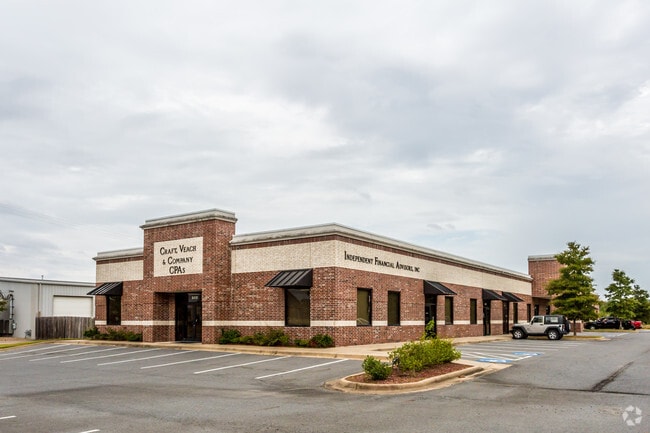
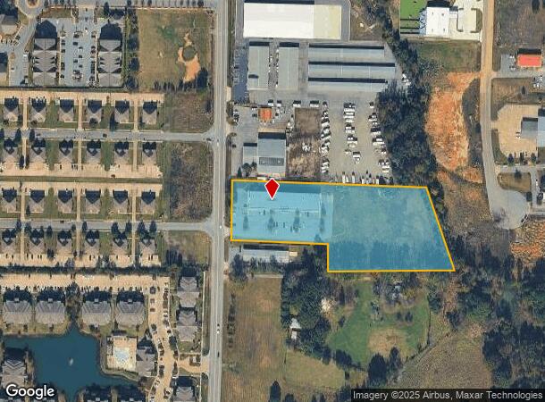
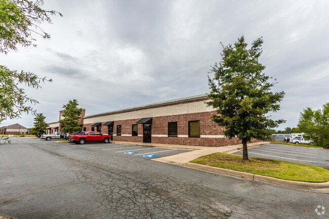
8410 Counts Massie Rd
Little Rock-North Little Rock-Conway, AR
Jb Enterprises Sub
43N-011-07-002-00
LOT 2 (REPLAT OF LOT 1)
Officebuilding
Pulaski
AE
Arkansas
05119C0309G
2
2025
4.58 AC
2025
Outlying Pulaski County
004307
Little Rock/N Little Rock
15,120 SF
DEMOGRAPHICS near 8410 Counts Massie Rd
1 Mile
3 Mile
5 Mile
2024 Total Population
5,731
22,542
54,735
2029 Population
5,705
22,323
54,112
Pop Growth 2024-2029
(0.45%)
(0.97%)
(1.14%)
Average Age
36
39
40
2024 Total Households
2,840
10,049
23,806
HH Growth 2024-2029
(0.32%)
(0.93%)
(1.12%)
Median Household Inc
$56,569
$64,965
$74,285
Avg Household Size
2.00
2.20
2.30
2024 Avg HH Vehicles
2.00
2.00
2.00
Median Home Value
$265,943
$242,288
$253,193
Median Year Built
2008
2000
1989
Nearby Places
- Restaurants
- Banks
- Shops
- Fitness
- Groceries
PUBLIC TRANSPORTATION
AIRPORT
Bill and Hillary Clinton Ntl/Adams Field
DRIVE
WALK
Distance
Bill and Hillary Clinton Ntl/Adams Field
22 min
16.1 mi
Freight Ports
Port of Shreveport
DRIVE
WALK
Distance
Port of Shreveport
255 min
236.8 mi
SALE & LEASE HISTORY
LISTING DATE
SALE/LEASE

Mar 09, 2022
For Lease
Jan 26, 2018
For Lease
Aug 14, 2023
For Lease
Nearby Properties
Address
Land Use
TOTAL SIZE
Lot Size
Zoning
Address
Land Use
TOTAL SIZE
Lot Size
Zoning
1,160,360 SF
119.55 AC
Address
Land Use
TOTAL SIZE
Lot Size
Zoning
28,414 SF
80.25 AC
Address
Land Use
TOTAL SIZE
Lot Size
Zoning
320,000 SF
91.54 AC
Address
Land Use
TOTAL SIZE
Lot Size
Zoning
89,847 SF
12.77 AC
Address
Land Use
TOTAL SIZE
Lot Size
Zoning
35,712 SF
19.92 AC
Address
Land Use
TOTAL SIZE
Lot Size
Zoning
1,974 SF
14.30 AC
Address
Land Use
TOTAL SIZE
Lot Size
Zoning
80,720 SF
15.62 AC
Address
Land Use
TOTAL SIZE
Lot Size
Zoning
55,997 SF
11.51 AC
Address
Land Use
TOTAL SIZE
Lot Size
Zoning
83,352 SF
6.90 AC
Address
Land Use
TOTAL SIZE
Lot Size
Zoning
77,478 SF
38.22 AC
Address
Land Use
TOTAL SIZE
Lot Size
Zoning
18,904 SF
12.73 AC
Address
Land Use
TOTAL SIZE
Lot Size
Zoning
12,077 SF
27.97 AC
Address
Land Use
TOTAL SIZE
Lot Size
Zoning
484,932 SF
32.85 AC
Address
Land Use
TOTAL SIZE
Lot Size
Zoning
157,500 SF
54.99 AC
Address
Land Use
TOTAL SIZE
Lot Size
Zoning
2,340 SF
37.56 AC
Address
Land Use
TOTAL SIZE
Lot Size
Zoning
192,104 SF
34.51 AC
Address
Land Use
TOTAL SIZE
Lot Size
Zoning
93,503 SF
34.50 AC
Address
Land Use
TOTAL SIZE
Lot Size
Zoning
139,444 SF
7.63 AC
Address
Land Use
TOTAL SIZE
Lot Size
Zoning
42,313 SF
5.17 AC
Address
Land Use
TOTAL SIZE
Lot Size
Zoning
8,624 SF
10.37 AC
Address
Land Use
TOTAL SIZE
Lot Size
Zoning
39,082 SF
3.62 AC
Address
Land Use
TOTAL SIZE
Lot Size
Zoning
188,528 SF
24.29 AC
Address
Land Use
TOTAL SIZE
Lot Size
Zoning
66,619 SF
5.89 AC
Address
Land Use
TOTAL SIZE
Lot Size
Zoning
56,423 SF
Address
Land Use
TOTAL SIZE
Lot Size
Zoning
8,417 SF
101 AC
Address
Land Use
TOTAL SIZE
Lot Size
Zoning
12,346 SF
14.41 AC
Address
Land Use
TOTAL SIZE
Lot Size
Zoning
74,384 SF
16.97 AC
Address
Land Use
TOTAL SIZE
Lot Size
Zoning
38,369 SF
10.04 AC
Address
Land Use
TOTAL SIZE
Lot Size
Zoning
60,966 SF
21.82 AC
Address
Land Use
TOTAL SIZE
Lot Size
Zoning
6,357 SF
10.80 AC
The World's #1 Commercial Real Estate Marketplace
Connect with us
© 2025 CoStar Group
The information above has been obtained from sources believed reliable. While we do not doubt its accuracy we have not verified it and make no guarantee, warranty or representation about it. It is your responsibility to independently confirm its accuracy and completeness. Any projections, opinions, assumptions, or estimates used are for example only and do not represent the current or future performance of the property. The value of this transaction to you depends on tax and other factors which should be evaluated by your tax, financial, and legal advisors. You and your advisors should conduct a careful, independent investigation of the property to determine to your satisfaction the suitability of the property for your needs.