Property Record
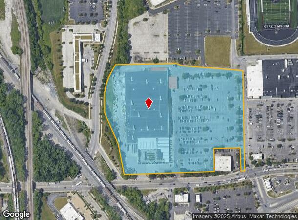
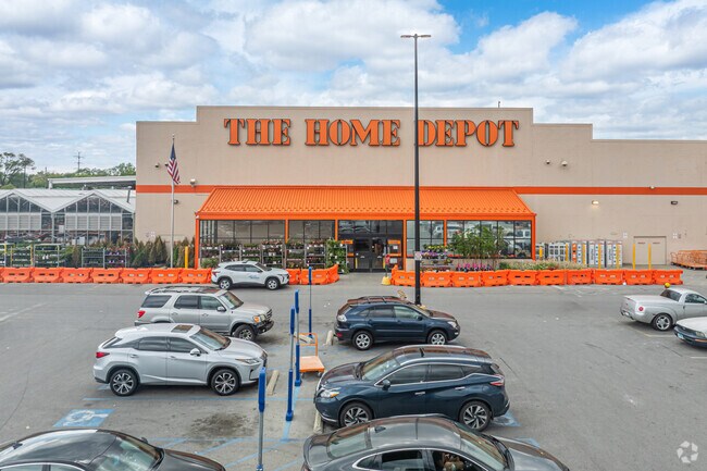
8410 S Stewart Ave, Chicago, IL 60620

NEARBY LISTINGS FOR SALE OR LEASE
Property Detail
8410 S Stewart Ave
20-33-305-041-0000
Dan Ryan Home Depot Subdivision
Commercialbuilding
Cook
X
Illinois
17031C0635J
2
2023
10.60 AC
2024
South Chicago
711100
Chicago
111,198 SF
Chicago-Naperville-Elgin, IL-IN-WI
DEMOGRAPHICS near 8410 S Stewart Ave
1 Mile
3 Mile
5 Mile
2024 Total Population
21,967
236,401
627,861
2029 Population
21,150
228,406
605,991
Pop Growth 2024-2029
(3.72%)
(3.38%)
(3.48%)
Average Age
41
41
39
2024 Total Households
8,546
94,830
245,366
HH Growth 2024-2029
(4.20%)
(3.82%)
(3.70%)
Median Household Inc
$49,884
$42,238
$43,516
Avg Household Size
2.50
2.40
2.40
2024 Avg HH Vehicles
1.00
1.00
1.00
Median Home Value
$173,489
$172,720
$186,604
Median Year Built
1950
1948
1949
Nearby Places
Map Layers
Map Styles
 Street
 Aerial
- Restaurants
- Banks
- Shops
- Fitness
- Groceries
PUBLIC TRANSPORTATION
TRANSIT/SUBWAY
87th Street Station (Red Line - Chicago Transit Authority "L" Trains (The "L"))
DRIVE
WALK
Distance
87th Street Station (Red Line - Chicago Transit Authority "L" Trains (The "L"))
5 min
9 min
0.4 mi
Gresham Station (Rock Island District Line - Northeast Illinois Regional Commuter Railroad (Metra))
DRIVE
WALK
Distance
Gresham Station (Rock Island District Line - Northeast Illinois Regional Commuter Railroad (Metra))
2 min
17 min
0.9 mi
COMMUTER RAIL
Gresham Station (Rock Island District Line - Northeast Illinois Regional Commuter Railroad (Metra))
DRIVE
WALK
Distance
Gresham Station (Rock Island District Line - Northeast Illinois Regional Commuter Railroad (Metra))
2 min
17 min
0.9 mi
Brainerd Station (Rock Island District Line - Northeast Illinois Regional Commuter Railroad (Metra))
DRIVE
WALK
Distance
Brainerd Station (Rock Island District Line - Northeast Illinois Regional Commuter Railroad (Metra))
4 min
1.8 mi
AIRPORT
Chicago Midway International
DRIVE
WALK
Distance
Chicago Midway International
20 min
10.5 mi
Chicago O'Hare International
DRIVE
WALK
Distance
Chicago O'Hare International
42 min
27.9 mi
SALE & LEASE HISTORY
LISTING DATE
SALE/LEASE

Mar 28, 2018
For Sale
Dec 01, 2017
For Sale
Nearby Properties
Address
Land Use
TOTAL SIZE
Lot Size
Zoning
Address
Land Use
TOTAL SIZE
Lot Size
Zoning
10.73 AC
PD 1243
Address
Land Use
TOTAL SIZE
Lot Size
Zoning
115,000 SF
1.97 AC
C1-2
Address
Land Use
TOTAL SIZE
Lot Size
Zoning
159,300 SF
13.36 AC
PD 425
Address
Land Use
TOTAL SIZE
Lot Size
Zoning
87,830 SF
0.76 AC
B1-1
Address
Land Use
TOTAL SIZE
Lot Size
Zoning
115,000 SF
1.12 AC
C1-2
Address
Land Use
TOTAL SIZE
Lot Size
Zoning
157,787 SF
12.23 AC
Address
Land Use
TOTAL SIZE
Lot Size
Zoning
7,200 SF
0.22 AC
B3-3
Address
Land Use
TOTAL SIZE
Lot Size
Zoning
148,700 SF
Address
Land Use
TOTAL SIZE
Lot Size
Zoning
223,310 SF
15.67 AC
Address
Land Use
TOTAL SIZE
Lot Size
Zoning
622,934 SF
34.41 AC
M2-3
Address
Land Use
TOTAL SIZE
Lot Size
Zoning
224,089 SF
Address
Land Use
TOTAL SIZE
Lot Size
Zoning
7.47 AC
RT-4
Address
Land Use
TOTAL SIZE
Lot Size
Zoning
13,700 SF
0.33 AC
B3-2
Address
Land Use
TOTAL SIZE
Lot Size
Zoning
141,165 SF
7.82 AC
PD 966
Address
Land Use
TOTAL SIZE
Lot Size
Zoning
15,052 SF
1.03 AC
PQ
Address
Land Use
TOTAL SIZE
Lot Size
Zoning
101,294 SF
8.10 AC
B3-1
Address
Land Use
TOTAL SIZE
Lot Size
Zoning
145,291 SF
7.85 AC
B3-2
Address
Land Use
TOTAL SIZE
Lot Size
Zoning
743,663 SF
7.14 AC
RT-4
Address
Land Use
TOTAL SIZE
Lot Size
Zoning
0.54 AC
RS-3
Address
Land Use
TOTAL SIZE
Lot Size
Zoning
76,867 SF
3.44 AC
M1-1
Address
Land Use
TOTAL SIZE
Lot Size
Zoning
207,100 SF
9.84 AC
M2-2
Address
Land Use
TOTAL SIZE
Lot Size
Zoning
9.55 AC
M2-2
Address
Land Use
TOTAL SIZE
Lot Size
Zoning
72,219 SF
4.30 AC
M1-2
Address
Land Use
TOTAL SIZE
Lot Size
Zoning
84,400 SF
15.18 AC
M2-2,M1-1
Address
Land Use
TOTAL SIZE
Lot Size
Zoning
115,918 SF
4.08 AC
M1-2,C1-1
Address
Land Use
TOTAL SIZE
Lot Size
Zoning
69,857 SF
5.39 AC
PD 338
Address
Land Use
TOTAL SIZE
Lot Size
Zoning
12.42 AC
PD 485
Address
Land Use
TOTAL SIZE
Lot Size
Zoning
71,700 SF
6.24 AC
PD 485
Address
Land Use
TOTAL SIZE
Lot Size
Zoning
65,186 SF
10.47 AC
PD 566
The World's #1 Commercial Real Estate Marketplace
Connect with us
© 2025 CoStar Group
The information above has been obtained from sources believed reliable. While we do not doubt its accuracy we have not verified it and make no guarantee, warranty or representation about it. It is your responsibility to independently confirm its accuracy and completeness. Any projections, opinions, assumptions, or estimates used are for example only and do not represent the current or future performance of the property. The value of this transaction to you depends on tax and other factors which should be evaluated by your tax, financial, and legal advisors. You and your advisors should conduct a careful, independent investigation of the property to determine to your satisfaction the suitability of the property for your needs.