Property Record
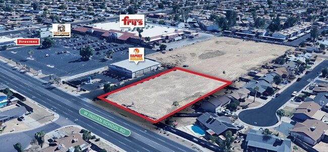
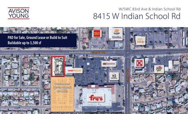
8415 W Indian School Rd, Phoenix, AZ 85037

This Property Is For Sale
NEARBY LISTINGS FOR SALE OR LEASE
Property Detail
8415 W Indian School Rd
Phoenix
LOT 2A MCR 1603-35 P/F 20210905224
Phoenix-Mesa-Scottsdale, AZ
Maricopa
102-23-918A
Arizona
Commercialacreage
2a
2025
0.93 AC
2025
Loop 101/I-10
082010
DEMOGRAPHICS near 8415 W Indian School Rd
1 Mile
3 Mile
5 Mile
2024 Total Population
28,929
166,686
355,797
2029 Population
31,055
180,394
384,373
Pop Growth 2024-2029
+ 7.35%
+ 8.22%
+ 8.03%
Average Age
33
33
33
2024 Total Households
7,486
47,201
103,657
HH Growth 2024-2029
+ 7.39%
+ 8.44%
+ 8.27%
Median Household Inc
$59,262
$62,065
$59,490
Avg Household Size
3.70
3.40
3.30
2024 Avg HH Vehicles
2.00
2.00
2.00
Median Home Value
$238,133
$258,688
$258,193
Median Year Built
1976
1987
1987
Nearby Places
Map Layers
Map Styles
 Street
 Aerial
- Restaurants
- Banks
- Shops
- Fitness
- Groceries
PUBLIC TRANSPORTATION
AIRPORT
Phoenix Sky Harbor International
DRIVE
WALK
Distance
Phoenix Sky Harbor International
26 min
18.1 mi
Freight Ports
Port of San Diego
DRIVE
WALK
Distance
Port of San Diego
386 min
347.0 mi
Nearby Properties
Address
Land Use
TOTAL SIZE
Lot Size
Zoning
Address
Land Use
TOTAL SIZE
Lot Size
Zoning
1,449,251 SF
25.30 AC
A1
Address
Land Use
TOTAL SIZE
Lot Size
Zoning
896,916 SF
25.91 AC
C-C
Address
Land Use
TOTAL SIZE
Lot Size
Zoning
630,367 SF
13.50 AC
PAD
Address
Land Use
TOTAL SIZE
Lot Size
Zoning
74,628 SF
2.74 AC
PAD
Address
Land Use
TOTAL SIZE
Lot Size
Zoning
1,267,497 SF
70.43 AC
A1
Address
Land Use
TOTAL SIZE
Lot Size
Zoning
1,100,500 SF
57.61 AC
PUD
Address
Land Use
TOTAL SIZE
Lot Size
Zoning
687,993 SF
48.80 AC
Address
Land Use
TOTAL SIZE
Lot Size
Zoning
285,815 SF
37.17 AC
R-6
Address
Land Use
TOTAL SIZE
Lot Size
Zoning
348,753 SF
19.36 AC
R-6
Address
Land Use
TOTAL SIZE
Lot Size
Zoning
533,718 SF
36.10 AC
PAD
Address
Land Use
TOTAL SIZE
Lot Size
Zoning
587,843 SF
20.49 AC
PAD
Address
Land Use
TOTAL SIZE
Lot Size
Zoning
258,097 SF
32.53 AC
AG
Address
Land Use
TOTAL SIZE
Lot Size
Zoning
351,903 SF
29.13 AC
A1
Address
Land Use
TOTAL SIZE
Lot Size
Zoning
660,838 SF
29.28 AC
C2
Address
Land Use
TOTAL SIZE
Lot Size
Zoning
135,052 SF
5.52 AC
PAD
Address
Land Use
TOTAL SIZE
Lot Size
Zoning
432,022 SF
19.33 AC
PAD
Address
Land Use
TOTAL SIZE
Lot Size
Zoning
660,980 SF
40.15 AC
Address
Land Use
TOTAL SIZE
Lot Size
Zoning
660,807 SF
31.44 AC
PAD-14
Address
Land Use
TOTAL SIZE
Lot Size
Zoning
269,894 SF
22.73 AC
R3A
Address
Land Use
TOTAL SIZE
Lot Size
Zoning
330,321 SF
3.85 AC
PAD
Address
Land Use
TOTAL SIZE
Lot Size
Zoning
498,064 SF
12.92 AC
C-N
Address
Land Use
TOTAL SIZE
Lot Size
Zoning
370,522 SF
9.45 AC
Address
Land Use
TOTAL SIZE
Lot Size
Zoning
1.05 AC
Address
Land Use
TOTAL SIZE
Lot Size
Zoning
409,017 SF
14.30 AC
Address
Land Use
TOTAL SIZE
Lot Size
Zoning
92,600 SF
20 AC
C-C
Address
Land Use
TOTAL SIZE
Lot Size
Zoning
253,047 SF
8.78 AC
PAD
Address
Land Use
TOTAL SIZE
Lot Size
Zoning
252,543 SF
10.85 AC
PAD
Address
Land Use
TOTAL SIZE
Lot Size
Zoning
370,119 SF
18.79 AC
M-H
Address
Land Use
TOTAL SIZE
Lot Size
Zoning
108,128 SF
18.55 AC
R-43AG
Address
Land Use
TOTAL SIZE
Lot Size
Zoning
106,215 SF
27.96 AC
PF
The World's #1 Commercial Real Estate Marketplace
Connect with us
© 2025 CoStar Group
The information above has been obtained from sources believed reliable. While we do not doubt its accuracy we have not verified it and make no guarantee, warranty or representation about it. It is your responsibility to independently confirm its accuracy and completeness. Any projections, opinions, assumptions, or estimates used are for example only and do not represent the current or future performance of the property. The value of this transaction to you depends on tax and other factors which should be evaluated by your tax, financial, and legal advisors. You and your advisors should conduct a careful, independent investigation of the property to determine to your satisfaction the suitability of the property for your needs.