Property Record
8415 Whitcomb Appr St, Merrillville, IN 46410
This Property Is For Sale
NEARBY LISTINGS FOR SALE OR LEASE
Property Detail
8415 Whitcomb Appr St
Chicago-Naperville-Elgin, IL-IN-WI
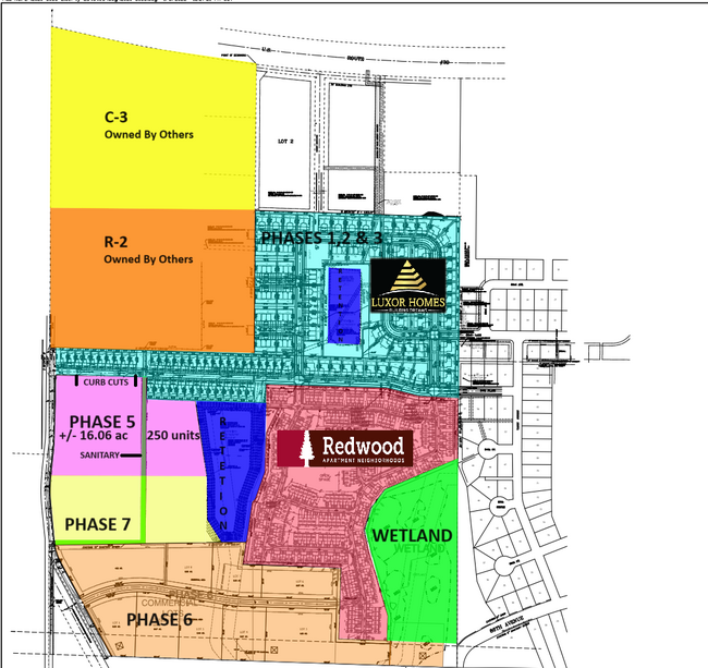
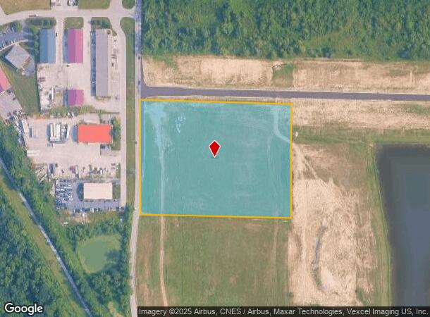
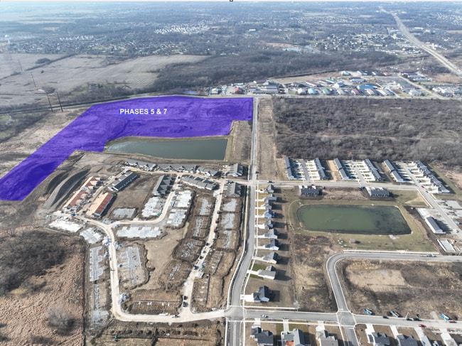
PT. SE.1/4 S.19 T.35 R.8 (631.01X477.23FT) 6.88AC
45-12-19-451-004.000-030
Lake
Agriculturalland
Indiana
X
1
18089C0234E
6.88 AC
2023
Indiana
2024
Chicago
042404
DEMOGRAPHICS near 8415 Whitcomb Appr St
1 Mile
3 Mile
5 Mile
2024 Total Population
5,846
49,375
113,678
2029 Population
5,855
49,309
113,875
Pop Growth 2024-2029
+ 0.15%
(0.13%)
+ 0.17%
Average Age
38
42
41
2024 Total Households
2,167
19,645
44,661
HH Growth 2024-2029
+ 0.14%
(0.09%)
+ 0.14%
Median Household Inc
$74,344
$73,308
$75,751
Avg Household Size
2.50
2.40
2.50
2024 Avg HH Vehicles
2.00
2.00
2.00
Median Home Value
$214,586
$222,146
$233,822
Median Year Built
1980
1987
1980
Nearby Places
- Restaurants
- Banks
- Shops
- Fitness
- Groceries
PUBLIC TRANSPORTATION
COMMUTER RAIL
Dyer Amtrak (Cardinal - Amtrak)
DRIVE
WALK
Distance
Dyer Amtrak (Cardinal - Amtrak)
17 min
9.3 mi
AIRPORT
Chicago Midway International
DRIVE
WALK
Distance
Chicago Midway International
59 min
37.6 mi
Freight Ports
Port Milwaukee
DRIVE
WALK
Distance
Port Milwaukee
162 min
123.8 mi
Nearby Properties
Address
Land Use
TOTAL SIZE
Lot Size
Zoning
Address
Land Use
TOTAL SIZE
Lot Size
Zoning
598,983 SF
88 AC
Address
Land Use
TOTAL SIZE
Lot Size
Zoning
206,854 SF
8.38 AC
Address
Land Use
TOTAL SIZE
Lot Size
Zoning
536,896 SF
20.08 AC
Address
Land Use
TOTAL SIZE
Lot Size
Zoning
377,878 SF
21.58 AC
Address
Land Use
TOTAL SIZE
Lot Size
Zoning
365,748 SF
17.44 AC
R33
Address
Land Use
TOTAL SIZE
Lot Size
Zoning
289,840 SF
15.31 AC
Address
Land Use
TOTAL SIZE
Lot Size
Zoning
236,904 SF
11.30 AC
R33
Address
Land Use
TOTAL SIZE
Lot Size
Zoning
116,352 SF
9 AC
Address
Land Use
TOTAL SIZE
Lot Size
Zoning
116,352 SF
8.08 AC
Address
Land Use
TOTAL SIZE
Lot Size
Zoning
132,147 SF
44.38 AC
R33
Address
Land Use
TOTAL SIZE
Lot Size
Zoning
108,193 SF
2.42 AC
Address
Land Use
TOTAL SIZE
Lot Size
Zoning
329,040 SF
30.19 AC
Address
Land Use
TOTAL SIZE
Lot Size
Zoning
190,352 SF
12.36 AC
Address
Land Use
TOTAL SIZE
Lot Size
Zoning
304,429 SF
84.07 AC
Address
Land Use
TOTAL SIZE
Lot Size
Zoning
237,291 SF
33.51 AC
R33
Address
Land Use
TOTAL SIZE
Lot Size
Zoning
87,264 SF
7.74 AC
Address
Land Use
TOTAL SIZE
Lot Size
Zoning
45,397 SF
14.48 AC
Address
Land Use
TOTAL SIZE
Lot Size
Zoning
92,823 SF
8.56 AC
Address
Land Use
TOTAL SIZE
Lot Size
Zoning
94,527 SF
6.10 AC
R33
Address
Land Use
TOTAL SIZE
Lot Size
Zoning
71,786 SF
9.20 AC
R33
Address
Land Use
TOTAL SIZE
Lot Size
Zoning
125,172 SF
5.57 AC
R33
Address
Land Use
TOTAL SIZE
Lot Size
Zoning
216,197 SF
13.89 AC
Address
Land Use
TOTAL SIZE
Lot Size
Zoning
111,516 SF
6.42 AC
Address
Land Use
TOTAL SIZE
Lot Size
Zoning
66,464 SF
43.30 AC
Address
Land Use
TOTAL SIZE
Lot Size
Zoning
52,896 SF
4.06 AC
R33
Address
Land Use
TOTAL SIZE
Lot Size
Zoning
41,015 SF
4.87 AC
Address
Land Use
TOTAL SIZE
Lot Size
Zoning
103,356 SF
7 AC
Address
Land Use
TOTAL SIZE
Lot Size
Zoning
122,908 SF
9.58 AC
Address
Land Use
TOTAL SIZE
Lot Size
Zoning
63,336 SF
4.55 AC
R33
Address
Land Use
TOTAL SIZE
Lot Size
Zoning
67,708 SF
3.08 AC
R33
The World's #1 Commercial Real Estate Marketplace
Connect with us
© 2025 CoStar Group
The information above has been obtained from sources believed reliable. While we do not doubt its accuracy we have not verified it and make no guarantee, warranty or representation about it. It is your responsibility to independently confirm its accuracy and completeness. Any projections, opinions, assumptions, or estimates used are for example only and do not represent the current or future performance of the property. The value of this transaction to you depends on tax and other factors which should be evaluated by your tax, financial, and legal advisors. You and your advisors should conduct a careful, independent investigation of the property to determine to your satisfaction the suitability of the property for your needs.