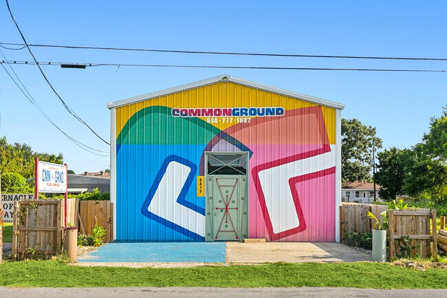
Property Record
8417 W St Bernard Hwy, Arabi, LA 70032

NEARBY LISTINGS FOR SALE OR LEASE
-
-
-
No Photo
-
View all Arabi listings for sale on LoopNet.com
Property Detail
8417 W St Bernard Hwy
New Orleans-Metairie, LA
Chalmette Subdivision
250800100009
LOTS 9, 10, 18, 19, 20 SQ.1 CHALMETTE SUB. -LOTS 9 & 10 EA. MEAS. 20' ST. BERNARD HWY. X 100' -LOTS 18, 19, & 20 EA. MEAS.
Storebuilding
St Bernard
AE
Louisiana
22087C0478D
9,10,18
2024
0.23 AC
2025
Chalmette
030400
New Orleans/Metairie/Kenner
DEMOGRAPHICS near 8417 W St Bernard Hwy
1 Mile
3 Mile
5 Mile
2024 Total Population
5,239
67,106
158,200
2029 Population
5,450
66,002
155,213
Pop Growth 2024-2029
+ 4.03%
(1.65%)
(1.89%)
Average Age
36
39
40
2024 Total Households
2,020
26,026
65,318
HH Growth 2024-2029
+ 3.66%
(2.08%)
(1.99%)
Median Household Inc
$47,909
$44,188
$45,644
Avg Household Size
2.60
2.50
2.30
2024 Avg HH Vehicles
2.00
1.00
1.00
Median Home Value
$157,448
$178,866
$199,940
Median Year Built
1973
1971
1967
Nearby Places
Map Layers
Map Styles
 Street
 Aerial
- Restaurants
- Banks
- Shops
- Fitness
- Groceries
PUBLIC TRANSPORTATION
COMMUTER RAIL
DRIVE
WALK
Distance
17 min
7.0 mi
AIRPORT
Louis Armstrong New Orleans International
DRIVE
WALK
Distance
Louis Armstrong New Orleans International
34 min
20.3 mi
SALE & LEASE HISTORY
LISTING DATE
SALE/LEASE

Oct 01, 2024
For Sale
Nearby Properties
Address
Land Use
TOTAL SIZE
Lot Size
Zoning
Address
Land Use
TOTAL SIZE
Lot Size
Zoning
Address
Land Use
TOTAL SIZE
Lot Size
Zoning
1.33 AC
HI
Address
Land Use
TOTAL SIZE
Lot Size
Zoning
85,568 SF
23.74 AC
MU-1
Address
Land Use
TOTAL SIZE
Lot Size
Zoning
0.20 AC
Address
Land Use
TOTAL SIZE
Lot Size
Zoning
Address
Land Use
TOTAL SIZE
Lot Size
Zoning
109,688 SF
8.77 AC
S-RM1
Address
Land Use
TOTAL SIZE
Lot Size
Zoning
Address
Land Use
TOTAL SIZE
Lot Size
Zoning
140,772 SF
9.01 AC
S-RS
Address
Land Use
TOTAL SIZE
Lot Size
Zoning
Address
Land Use
TOTAL SIZE
Lot Size
Zoning
4.40 AC
Address
Land Use
TOTAL SIZE
Lot Size
Zoning
Address
Land Use
TOTAL SIZE
Lot Size
Zoning
Address
Land Use
TOTAL SIZE
Lot Size
Zoning
147,253 SF
9.95 AC
S-RM1
Address
Land Use
TOTAL SIZE
Lot Size
Zoning
Address
Land Use
TOTAL SIZE
Lot Size
Zoning
16.84 AC
EC
Address
Land Use
TOTAL SIZE
Lot Size
Zoning
8.11 AC
EC
Address
Land Use
TOTAL SIZE
Lot Size
Zoning
159,090 SF
23.56 AC
Address
Land Use
TOTAL SIZE
Lot Size
Zoning
82,611 SF
1.94 AC
HU-RM1
Address
Land Use
TOTAL SIZE
Lot Size
Zoning
Address
Land Use
TOTAL SIZE
Lot Size
Zoning
Address
Land Use
TOTAL SIZE
Lot Size
Zoning
2.06 AC
EC
Address
Land Use
TOTAL SIZE
Lot Size
Zoning
Address
Land Use
TOTAL SIZE
Lot Size
Zoning
6,540 SF
116 AC
OS-R
Address
Land Use
TOTAL SIZE
Lot Size
Zoning
53,964 SF
8.06 AC
S-RS
Address
Land Use
TOTAL SIZE
Lot Size
Zoning
20.49 AC
MU-2
Address
Land Use
TOTAL SIZE
Lot Size
Zoning
Address
Land Use
TOTAL SIZE
Lot Size
Zoning
574,842 SF
53.74 AC
S-RM1
Address
Land Use
TOTAL SIZE
Lot Size
Zoning
13,608 SF
67.27 AC
OS-N
Address
Land Use
TOTAL SIZE
Lot Size
Zoning
0.92 AC
Address
Land Use
TOTAL SIZE
Lot Size
Zoning
The World's #1 Commercial Real Estate Marketplace
Connect with us
© 2026 CoStar Group
The information above has been obtained from sources believed reliable. While we do not doubt its accuracy we have not verified it and make no guarantee, warranty or representation about it. It is your responsibility to independently confirm its accuracy and completeness. Any projections, opinions, assumptions, or estimates used are for example only and do not represent the current or future performance of the property. The value of this transaction to you depends on tax and other factors which should be evaluated by your tax, financial, and legal advisors. You and your advisors should conduct a careful, independent investigation of the property to determine to your satisfaction the suitability of the property for your needs.