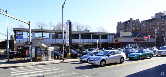
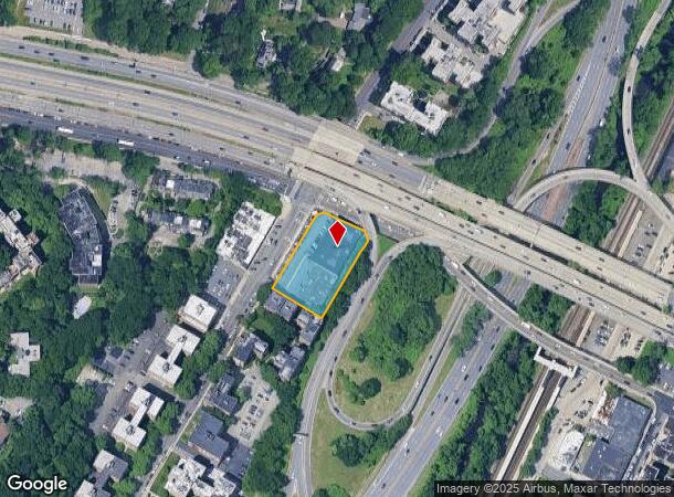
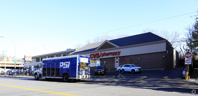
Property Record
842 Bronx River Rd, Bronxville, NY 10708
NEARBY LISTINGS FOR SALE OR LEASE
-
-
-
-
-
-
-
-
-
-
-
-
-
-
-
-
-
-
-
-
-
-
-
-
-
-
-
No Photo
-
-
View all Bronxville listings for lease on LoopNet.com
Property Detail
842 Bronx River Rd
1800-005-000-05257-000-0007
Westchester
Stripcommercialcenter
New York
X
7.000
36119C0337F
0.86 AC
2025
Southwest
2024
Westchester/So Connecticut
004600
New York-Jersey City-White Plains, NY-NJ
29,126 SF
DEMOGRAPHICS near 842 Bronx River Rd
1 mile
3 mile
5 mile
2024 Total Population
39,083
335,048
834,357
2029 Population
37,979
320,039
791,949
Pop Growth 2024-2029
(2.82%)
(4.48%)
(5.08%)
Average Age
43
40
40
2024 Total Households
16,505
123,101
310,091
HH Growth 2024-2029
(2.74%)
(4.65%)
(5.39%)
Median Household Inc
$87,958
$75,825
$69,610
Avg Household Size
2.30
2.60
2.60
2024 Avg HH Vehicles
1.00
1.00
1.00
Median Home Value
$424,331
$547,185
$553,884
Median Year Built
1949
1949
1952
Nearby Places
Map Layers
Map Styles
 Street
 Aerial
Transit
 Traffic
 Biking
Places
Listings with unknown addresses are not visible on the map
- Restaurants
- Banks
- Shops
- Fitness
- Groceries
PUBLIC TRANSPORTATION
COMMUTER RAIL
Fleetwood Station (Harlem Line - Metro-North Commuter Railroad Company (Metro-North))
Drive
Walk
Distance
Fleetwood Station (Harlem Line - Metro-North Commuter Railroad Company (Metro-North))
1 min
4 min
0.2 mi
Bronxville Station (Harlem Line - Metro-North Commuter Railroad Company (Metro-North))
Drive
Walk
Distance
Bronxville Station (Harlem Line - Metro-North Commuter Railroad Company (Metro-North))
3 min
1.1 mi
AIRPORT
LaGuardia
Drive
Walk
Distance
LaGuardia
28 min
16.2 mi
Westchester County
Drive
Walk
Distance
Westchester County
25 min
16.7 mi
John F Kennedy International
Drive
Walk
Distance
John F Kennedy International
35 min
23.8 mi
Freight Ports
NY - Red Hook Container Terminal
Drive
Walk
Distance
NY - Red Hook Container Terminal
41 min
23.9 mi
SALE & LEASE HISTORY
LISTING DATE
SALE/LEASE

Sep 25, 2016
For Lease
Oct 31, 2017
For Lease
Oct 31, 2017
For Lease
Nearby Properties
Address
Land Use
TOTAL SIZE
Lot Size
Zoning
Address
Land Use
TOTAL SIZE
Lot Size
Zoning
18,000 SF
13.85 AC
A
Address
Land Use
TOTAL SIZE
Lot Size
Zoning
201,590 SF
4.13 AC
BA
Address
Land Use
TOTAL SIZE
Lot Size
Zoning
301,156 SF
13.94 AC
A
Address
Land Use
TOTAL SIZE
Lot Size
Zoning
70,737 SF
1.67 AC
BB
Address
Land Use
TOTAL SIZE
Lot Size
Zoning
4,000 SF
19.83 AC
BUS
Address
Land Use
TOTAL SIZE
Lot Size
Zoning
617,567 SF
3.19 AC
R7-1
Address
Land Use
TOTAL SIZE
Lot Size
Zoning
131,086 SF
16.21 AC
IND
Address
Land Use
TOTAL SIZE
Lot Size
Zoning
Address
Land Use
TOTAL SIZE
Lot Size
Zoning
Address
Land Use
TOTAL SIZE
Lot Size
Zoning
269,100 SF
1.63 AC
R4
Address
Land Use
TOTAL SIZE
Lot Size
Zoning
64,165 SF
3.24 AC
B
Address
Land Use
TOTAL SIZE
Lot Size
Zoning
165,529 SF
7.05 AC
RA3
Address
Land Use
TOTAL SIZE
Lot Size
Zoning
1,028,976 SF
23.03 AC
R5
Address
Land Use
TOTAL SIZE
Lot Size
Zoning
1,038,034 SF
23.41 AC
R5
Address
Land Use
TOTAL SIZE
Lot Size
Zoning
5,170 SF
9.08 AC
B
Address
Land Use
TOTAL SIZE
Lot Size
Zoning
130,211 SF
1.80 AC
D
Address
Land Use
TOTAL SIZE
Lot Size
Zoning
336,240 SF
8.45 AC
R5
Address
Land Use
TOTAL SIZE
Lot Size
Zoning
219,285 SF
15.51 AC
R4
Address
Land Use
TOTAL SIZE
Lot Size
Zoning
103,158 SF
1.82 AC
R4
Address
Land Use
TOTAL SIZE
Lot Size
Zoning
113,690 SF
1.87 AC
D
Address
Land Use
TOTAL SIZE
Lot Size
Zoning
Address
Land Use
TOTAL SIZE
Lot Size
Zoning
38,912 SF
19.25 AC
R4
Address
Land Use
TOTAL SIZE
Lot Size
Zoning
7,855 SF
1.10 AC
C
Address
Land Use
TOTAL SIZE
Lot Size
Zoning
143,260 SF
1.79 AC
R5
Address
Land Use
TOTAL SIZE
Lot Size
Zoning
249,258 SF
1.58 AC
R5
Address
Land Use
TOTAL SIZE
Lot Size
Zoning
249,258 SF
1.58 AC
R5
Address
Land Use
TOTAL SIZE
Lot Size
Zoning
249,258 SF
1.58 AC
R5
Address
Land Use
TOTAL SIZE
Lot Size
Zoning
249,258 SF
1.58 AC
R5
Address
Land Use
TOTAL SIZE
Lot Size
Zoning
249,258 SF
1.58 AC
R5
Address
Land Use
TOTAL SIZE
Lot Size
Zoning
249,258 SF
1.58 AC
R5
The World's #1 Commercial Real Estate Marketplace
Connect with us
© 2026 CoStar Group
The information above has been obtained from sources believed reliable. While we do not doubt its accuracy we have not verified it and make no guarantee, warranty or representation about it. It is your responsibility to independently confirm its accuracy and completeness. Any projections, opinions, assumptions, or estimates used are for example only and do not represent the current or future performance of the property. The value of this transaction to you depends on tax and other factors which should be evaluated by your tax, financial, and legal advisors. You and your advisors should conduct a careful, independent investigation of the property to determine to your satisfaction the suitability of the property for your needs.