Property Record
8420 Asheville Hwy, Knoxville, TN 37924


NEARBY LISTINGS FOR SALE OR LEASE
-
-
View all Knoxville listings for sale on LoopNet.com
Property Detail
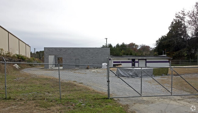
8420 Asheville Hwy
062-245
Division Of The Rhoda Smith Farm
Warehouse
Knox
X
Tennessee
47089C0125D
1.53 AC
2025
East
2025
Knoxville
005301
Knoxville, TN
15,548 SF
DEMOGRAPHICS near 8420 Asheville Hwy
1 Mile
3 Mile
5 Mile
2024 Total Population
1,521
9,095
22,180
2029 Population
1,664
9,974
24,266
Pop Growth 2024-2029
+ 9.40%
+ 9.66%
+ 9.40%
Average Age
42
42
42
2024 Total Households
597
3,598
8,850
HH Growth 2024-2029
+ 9.38%
+ 9.73%
+ 9.48%
Median Household Inc
$51,912
$66,972
$59,649
Avg Household Size
2.50
2.50
2.50
2024 Avg HH Vehicles
2.00
2.00
2.00
Median Home Value
$232,398
$232,579
$224,810
Median Year Built
1977
1985
1985
Nearby Places
Map Layers
Map Styles
 Street
 Aerial
- Restaurants
- Banks
- Shops
- Fitness
- Groceries
PUBLIC TRANSPORTATION
AIRPORT
McGhee Tyson
DRIVE
WALK
Distance
McGhee Tyson
44 min
29.3 mi
Freight Ports
North Charleston Terminal
DRIVE
WALK
Distance
North Charleston Terminal
409 min
351.2 mi
Nearby Properties
Address
Land Use
TOTAL SIZE
Lot Size
Zoning
Address
Land Use
TOTAL SIZE
Lot Size
Zoning
227,687 SF
18 AC
Address
Land Use
TOTAL SIZE
Lot Size
Zoning
37,534 SF
5.03 AC
Address
Land Use
TOTAL SIZE
Lot Size
Zoning
22,782 SF
11.02 AC
Address
Land Use
TOTAL SIZE
Lot Size
Zoning
44,159 SF
17.85 AC
Address
Land Use
TOTAL SIZE
Lot Size
Zoning
54,198 SF
2.67 AC
Address
Land Use
TOTAL SIZE
Lot Size
Zoning
9,479 SF
4.97 AC
Address
Land Use
TOTAL SIZE
Lot Size
Zoning
51,200 SF
2.01 AC
Address
Land Use
TOTAL SIZE
Lot Size
Zoning
43,456 SF
1.96 AC
Address
Land Use
TOTAL SIZE
Lot Size
Zoning
44,854 SF
11.04 AC
Address
Land Use
TOTAL SIZE
Lot Size
Zoning
42,598 SF
1.19 AC
Address
Land Use
TOTAL SIZE
Lot Size
Zoning
35,892 SF
2.47 AC
Address
Land Use
TOTAL SIZE
Lot Size
Zoning
48,588 SF
7.94 AC
Address
Land Use
TOTAL SIZE
Lot Size
Zoning
14,980 SF
7.50 AC
Address
Land Use
TOTAL SIZE
Lot Size
Zoning
38,095 SF
1.64 AC
Address
Land Use
TOTAL SIZE
Lot Size
Zoning
Address
Land Use
TOTAL SIZE
Lot Size
Zoning
25,906 SF
59.39 AC
Address
Land Use
TOTAL SIZE
Lot Size
Zoning
33,744 SF
2.66 AC
Address
Land Use
TOTAL SIZE
Lot Size
Zoning
28,680 SF
2.67 AC
Address
Land Use
TOTAL SIZE
Lot Size
Zoning
7,242 SF
2.43 AC
Address
Land Use
TOTAL SIZE
Lot Size
Zoning
10,000 SF
8.07 AC
Address
Land Use
TOTAL SIZE
Lot Size
Zoning
31,276 SF
1.79 AC
Address
Land Use
TOTAL SIZE
Lot Size
Zoning
3,534 SF
2.74 AC
Address
Land Use
TOTAL SIZE
Lot Size
Zoning
14,654 SF
6.42 AC
Address
Land Use
TOTAL SIZE
Lot Size
Zoning
6,022 SF
2.55 AC
Address
Land Use
TOTAL SIZE
Lot Size
Zoning
5,456 SF
139.05 AC
Address
Land Use
TOTAL SIZE
Lot Size
Zoning
5,788 SF
1.41 AC
Address
Land Use
TOTAL SIZE
Lot Size
Zoning
5,685 SF
2.37 AC
Address
Land Use
TOTAL SIZE
Lot Size
Zoning
2,160 SF
1.22 AC
Address
Land Use
TOTAL SIZE
Lot Size
Zoning
5,994 SF
2.32 AC
Address
Land Use
TOTAL SIZE
Lot Size
Zoning
4,742 SF
2.03 AC
The World's #1 Commercial Real Estate Marketplace
Connect with us
© 2025 CoStar Group
The information above has been obtained from sources believed reliable. While we do not doubt its accuracy we have not verified it and make no guarantee, warranty or representation about it. It is your responsibility to independently confirm its accuracy and completeness. Any projections, opinions, assumptions, or estimates used are for example only and do not represent the current or future performance of the property. The value of this transaction to you depends on tax and other factors which should be evaluated by your tax, financial, and legal advisors. You and your advisors should conduct a careful, independent investigation of the property to determine to your satisfaction the suitability of the property for your needs.