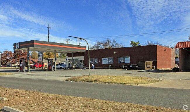
Property Record
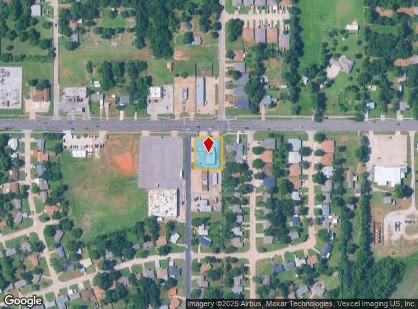
8420 Ne 10Th St, Oklahoma City, OK 73110

NEARBY LISTINGS FOR SALE OR LEASE
Property Detail
8420 Ne 10Th St
Oklahoma City, OK
Holman 3Rd Addition
155651005
HOLMAN 3RD ADDITION 000 000 N150FT OF LOT 1 BLK 1
Commercialnec
Oklahoma
X
Oklahoma
40109C0310H
1
2023
0.45 AC
2024
East Oklahoma County
108008
Oklahoma City
1,663 SF
DEMOGRAPHICS near 8420 Ne 10Th St
1 Mile
3 Mile
5 Mile
2024 Total Population
10,725
54,332
98,454
2029 Population
10,914
55,545
101,504
Pop Growth 2024-2029
+ 1.76%
+ 2.23%
+ 3.10%
Average Age
38
38
38
2024 Total Households
4,604
22,460
39,661
HH Growth 2024-2029
+ 1.74%
+ 2.16%
+ 2.96%
Median Household Inc
$40,562
$51,074
$52,170
Avg Household Size
2.30
2.30
2.40
2024 Avg HH Vehicles
2.00
2.00
2.00
Median Home Value
$114,268
$133,502
$140,092
Median Year Built
1976
1970
1971
Nearby Places
Map Layers
Map Styles
 Street
 Aerial
- Restaurants
- Banks
- Shops
- Fitness
- Groceries
PUBLIC TRANSPORTATION
COMMUTER RAIL
Oklahoma City (Heartland Flyer - Amtrak)
DRIVE
WALK
Distance
Oklahoma City (Heartland Flyer - Amtrak)
15 min
8.7 mi
AIRPORT
Will Rogers World
DRIVE
WALK
Distance
Will Rogers World
32 min
18.1 mi
Freight Ports
Tulsa Port Of Catoosa
DRIVE
WALK
Distance
Tulsa Port Of Catoosa
134 min
120.3 mi
Nearby Properties
Address
Land Use
TOTAL SIZE
Lot Size
Zoning
Address
Land Use
TOTAL SIZE
Lot Size
Zoning
318,692 SF
15.25 AC
Address
Land Use
TOTAL SIZE
Lot Size
Zoning
20,670 SF
3.56 AC
Address
Land Use
TOTAL SIZE
Lot Size
Zoning
219,768 SF
22 AC
Address
Land Use
TOTAL SIZE
Lot Size
Zoning
142,772 SF
11.07 AC
Address
Land Use
TOTAL SIZE
Lot Size
Zoning
242,484 SF
13.18 AC
Address
Land Use
TOTAL SIZE
Lot Size
Zoning
160,336 SF
29.58 AC
Address
Land Use
TOTAL SIZE
Lot Size
Zoning
233,016 SF
10.81 AC
Address
Land Use
TOTAL SIZE
Lot Size
Zoning
431,366 SF
17.57 AC
Address
Land Use
TOTAL SIZE
Lot Size
Zoning
10,050 SF
0.79 AC
Address
Land Use
TOTAL SIZE
Lot Size
Zoning
84,940 SF
9.58 AC
Address
Land Use
TOTAL SIZE
Lot Size
Zoning
216,000 SF
26.72 AC
Address
Land Use
TOTAL SIZE
Lot Size
Zoning
14,992 SF
1.34 AC
Address
Land Use
TOTAL SIZE
Lot Size
Zoning
124,997 SF
9.80 AC
Address
Land Use
TOTAL SIZE
Lot Size
Zoning
171,622 SF
9.74 AC
Address
Land Use
TOTAL SIZE
Lot Size
Zoning
8,811 SF
1.73 AC
Address
Land Use
TOTAL SIZE
Lot Size
Zoning
51,352 SF
21.12 AC
Address
Land Use
TOTAL SIZE
Lot Size
Zoning
94,261 SF
13.12 AC
Address
Land Use
TOTAL SIZE
Lot Size
Zoning
54,338 SF
10.24 AC
Address
Land Use
TOTAL SIZE
Lot Size
Zoning
81,960 SF
8.12 AC
Address
Land Use
TOTAL SIZE
Lot Size
Zoning
133,986 SF
12.28 AC
Address
Land Use
TOTAL SIZE
Lot Size
Zoning
74,184 SF
3.43 AC
Address
Land Use
TOTAL SIZE
Lot Size
Zoning
208,900 SF
10.15 AC
Address
Land Use
TOTAL SIZE
Lot Size
Zoning
62,506 SF
5.97 AC
Address
Land Use
TOTAL SIZE
Lot Size
Zoning
272,244 SF
14.69 AC
Address
Land Use
TOTAL SIZE
Lot Size
Zoning
133,916 SF
14.43 AC
Address
Land Use
TOTAL SIZE
Lot Size
Zoning
174,433 SF
8.41 AC
Address
Land Use
TOTAL SIZE
Lot Size
Zoning
135,134 SF
8.99 AC
Address
Land Use
TOTAL SIZE
Lot Size
Zoning
6,698 SF
10.73 AC
Address
Land Use
TOTAL SIZE
Lot Size
Zoning
10,492 SF
2.42 AC
Address
Land Use
TOTAL SIZE
Lot Size
Zoning
90,170 SF
6.54 AC
The World's #1 Commercial Real Estate Marketplace
Connect with us
© 2025 CoStar Group
The information above has been obtained from sources believed reliable. While we do not doubt its accuracy we have not verified it and make no guarantee, warranty or representation about it. It is your responsibility to independently confirm its accuracy and completeness. Any projections, opinions, assumptions, or estimates used are for example only and do not represent the current or future performance of the property. The value of this transaction to you depends on tax and other factors which should be evaluated by your tax, financial, and legal advisors. You and your advisors should conduct a careful, independent investigation of the property to determine to your satisfaction the suitability of the property for your needs.