Property Record
8421 Old Statesville Rd, Charlotte, NC 28269
NEARBY LISTINGS FOR SALE OR LEASE
Property Detail
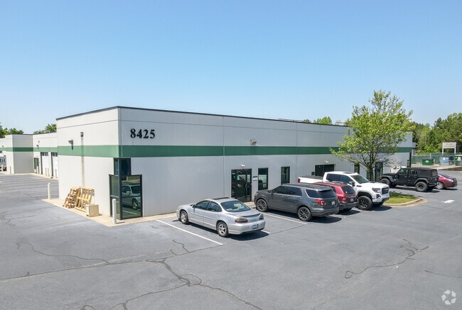
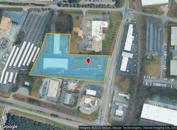
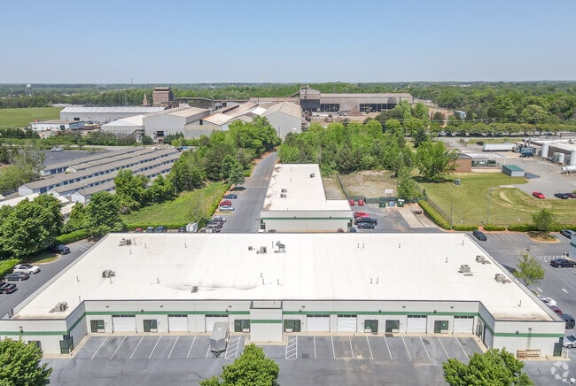
8421 Old Statesville Rd
037-253-19
PTR-B M34-498
Industrialgeneral
Mecklenburg
X
North Carolina
3710455800L
19
2024
6.45 AC
2025
North
005510
Charlotte
27,488 SF
Charlotte-Concord-Gastonia, NC-SC
DEMOGRAPHICS near 8421 Old Statesville Rd
1 Mile
3 Mile
5 Mile
2024 Total Population
5,382
71,285
155,347
2029 Population
5,705
75,354
164,600
Pop Growth 2024-2029
+ 6.00%
+ 5.71%
+ 5.96%
Average Age
35
36
36
2024 Total Households
1,872
27,859
60,236
HH Growth 2024-2029
+ 6.09%
+ 5.75%
+ 6.07%
Median Household Inc
$65,016
$67,639
$68,601
Avg Household Size
2.80
2.50
2.50
2024 Avg HH Vehicles
2.00
2.00
2.00
Median Home Value
$242,241
$253,011
$254,774
Median Year Built
1998
1999
2000
Nearby Places
Map Layers
Map Styles
 Street
 Aerial
- Restaurants
- Banks
- Shops
- Fitness
- Groceries
PUBLIC TRANSPORTATION
COMMUTER RAIL
Charlotte Amtrak Station (Carolinian - Amtrak, Crescent - Amtrak, Piedmont - Amtrak)
DRIVE
WALK
Distance
Charlotte Amtrak Station (Carolinian - Amtrak, Crescent - Amtrak, Piedmont - Amtrak)
15 min
8.0 mi
AIRPORT
Concord-Padgett Regional
DRIVE
WALK
Distance
Concord-Padgett Regional
16 min
9.4 mi
Charlotte/Douglas International
DRIVE
WALK
Distance
Charlotte/Douglas International
26 min
15.2 mi
Freight Ports
North Charleston Terminal
DRIVE
WALK
Distance
North Charleston Terminal
237 min
207.4 mi
Nearby Properties
Address
Land Use
TOTAL SIZE
Lot Size
Zoning
Address
Land Use
TOTAL SIZE
Lot Size
Zoning
497,730 SF
32.66 AC
B2CD
Address
Land Use
TOTAL SIZE
Lot Size
Zoning
719,240 SF
55.73 AC
CC
Address
Land Use
TOTAL SIZE
Lot Size
Zoning
641,285 SF
43.18 AC
I-1
Address
Land Use
TOTAL SIZE
Lot Size
Zoning
481,045 SF
36.15 AC
R12MFCD
Address
Land Use
TOTAL SIZE
Lot Size
Zoning
401,069 SF
31.52 AC
R12MFCD
Address
Land Use
TOTAL SIZE
Lot Size
Zoning
318,829 SF
26.68 AC
MX1INNOV
Address
Land Use
TOTAL SIZE
Lot Size
Zoning
256,254 SF
20.66 AC
R9MFCD
Address
Land Use
TOTAL SIZE
Lot Size
Zoning
322,507 SF
25.95 AC
I1
Address
Land Use
TOTAL SIZE
Lot Size
Zoning
295,520 SF
23.13 AC
R12MFCD
Address
Land Use
TOTAL SIZE
Lot Size
Zoning
232,382 SF
22.80 AC
R12MFCD
Address
Land Use
TOTAL SIZE
Lot Size
Zoning
346,306 SF
25.02 AC
MX2
Address
Land Use
TOTAL SIZE
Lot Size
Zoning
300,459 SF
18.93 AC
R17MFCD
Address
Land Use
TOTAL SIZE
Lot Size
Zoning
263,035 SF
10.42 AC
CC
Address
Land Use
TOTAL SIZE
Lot Size
Zoning
334,333 SF
19.33 AC
BP
Address
Land Use
TOTAL SIZE
Lot Size
Zoning
294,175 SF
20.23 AC
R12MFCD
Address
Land Use
TOTAL SIZE
Lot Size
Zoning
246,846 SF
13.56 AC
R3
Address
Land Use
TOTAL SIZE
Lot Size
Zoning
244,003 SF
26.78 AC
R12MFCD
Address
Land Use
TOTAL SIZE
Lot Size
Zoning
238,537 SF
16.52 AC
R17MFCD
Address
Land Use
TOTAL SIZE
Lot Size
Zoning
220,590 SF
16.23 AC
R15MFCD
Address
Land Use
TOTAL SIZE
Lot Size
Zoning
417,771 SF
14.55 AC
BP
Address
Land Use
TOTAL SIZE
Lot Size
Zoning
490,844 SF
40.50 AC
I-2(CD)
Address
Land Use
TOTAL SIZE
Lot Size
Zoning
304,185 SF
14.32 AC
UR-3(CD)
Address
Land Use
TOTAL SIZE
Lot Size
Zoning
505,355 SF
37.59 AC
Address
Land Use
TOTAL SIZE
Lot Size
Zoning
187,636 SF
16.56 AC
R17MFCD
Address
Land Use
TOTAL SIZE
Lot Size
Zoning
209,748 SF
12.38 AC
MX1INNOV
Address
Land Use
TOTAL SIZE
Lot Size
Zoning
211,601 SF
20.80 AC
Address
Land Use
TOTAL SIZE
Lot Size
Zoning
227,806 SF
27.96 AC
R12MFCD
Address
Land Use
TOTAL SIZE
Lot Size
Zoning
322,342 SF
19.64 AC
R12MFCD
Address
Land Use
TOTAL SIZE
Lot Size
Zoning
220,336 SF
11.52 AC
Address
Land Use
TOTAL SIZE
Lot Size
Zoning
221,187 SF
16.34 AC
R17MF
The World's #1 Commercial Real Estate Marketplace
Connect with us
© 2026 CoStar Group
The information above has been obtained from sources believed reliable. While we do not doubt its accuracy we have not verified it and make no guarantee, warranty or representation about it. It is your responsibility to independently confirm its accuracy and completeness. Any projections, opinions, assumptions, or estimates used are for example only and do not represent the current or future performance of the property. The value of this transaction to you depends on tax and other factors which should be evaluated by your tax, financial, and legal advisors. You and your advisors should conduct a careful, independent investigation of the property to determine to your satisfaction the suitability of the property for your needs.