Property Record
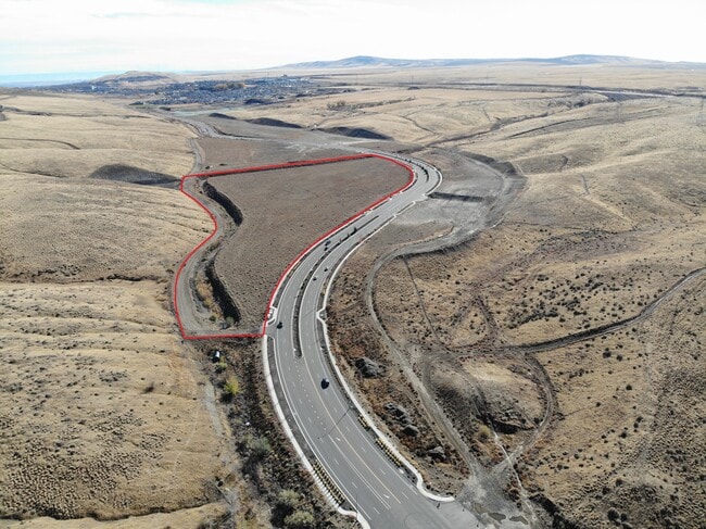
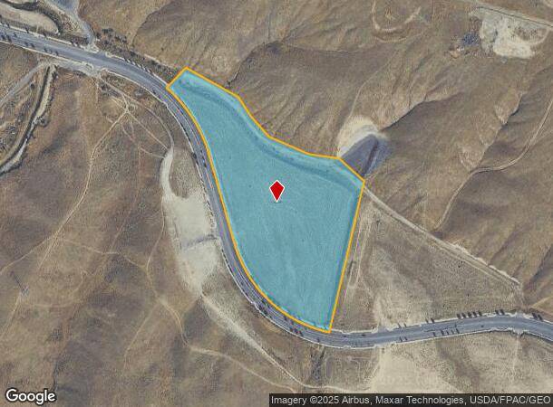
8428 Bob Olson Pkwy, Kennewick, WA 99337
This Property Is For Sale
NEARBY LISTINGS FOR SALE OR LEASE
Property Detail
8428 Bob Olson Pkwy
Other Market Areas
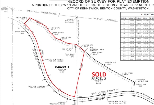
Short Plat 3622
Kennewick-Richland, WA
LOT 2 SHORT PLAT 3622 RECORDED IN VOLUME 1 OF SHORT PLATS AT PAGE 3622 UNDER AUDITORS FILE NUMBER 2019-026230 RECORDS OF BENTON COUNTY WASHINGTON TOGETHER WITH REAL PROPERTY SITUATED IN THE CITY OF KENNEWICK BENTON COUNTY WASHINGTON LYING IN THE
107894000001010
Benton
Storebuilding
Washington
2024
2
2024
19.27 AC
011402
Yakima/Kennewick
DEMOGRAPHICS near 8428 Bob Olson Pkwy
1 Mile
3 Mile
5 Mile
2024 Total Population
2,023
44,394
110,482
2029 Population
2,205
47,796
119,079
Pop Growth 2024-2029
+ 9.00%
+ 7.66%
+ 7.78%
Average Age
40
39
38
2024 Total Households
755
17,084
40,917
HH Growth 2024-2029
+ 9.14%
+ 7.69%
+ 7.83%
Median Household Inc
$98,538
$80,734
$78,165
Avg Household Size
2.70
2.60
2.70
2024 Avg HH Vehicles
2.00
2.00
2.00
Median Home Value
$425,423
$368,923
$364,681
Median Year Built
2004
1996
1992
Nearby Places
- Restaurants
- Banks
- Shops
- Fitness
- Groceries
PUBLIC TRANSPORTATION
AIRPORT
Tri-Cities
DRIVE
WALK
Distance
Tri-Cities
19 min
10.3 mi
Freight Ports
Port of Tacoma
DRIVE
WALK
Distance
Port of Tacoma
267 min
233.0 mi
Nearby Properties
Address
Land Use
TOTAL SIZE
Lot Size
Zoning
Address
Land Use
TOTAL SIZE
Lot Size
Zoning
614,021 SF
45.64 AC
Address
Land Use
TOTAL SIZE
Lot Size
Zoning
192,199 SF
Address
Land Use
TOTAL SIZE
Lot Size
Zoning
378,471 SF
16.21 AC
RICHLAND -
Address
Land Use
TOTAL SIZE
Lot Size
Zoning
190,434 SF
47.42 AC
Address
Land Use
TOTAL SIZE
Lot Size
Zoning
141,940 SF
7.49 AC
Address
Land Use
TOTAL SIZE
Lot Size
Zoning
138,421 SF
31.09 AC
Address
Land Use
TOTAL SIZE
Lot Size
Zoning
238,088 SF
17.06 AC
Address
Land Use
TOTAL SIZE
Lot Size
Zoning
195,749 SF
12.29 AC
35
Address
Land Use
TOTAL SIZE
Lot Size
Zoning
148,301 SF
6.41 AC
Address
Land Use
TOTAL SIZE
Lot Size
Zoning
224,114 SF
13.37 AC
Address
Land Use
TOTAL SIZE
Lot Size
Zoning
248,623 SF
12 AC
Address
Land Use
TOTAL SIZE
Lot Size
Zoning
168,650 SF
10.43 AC
KENNEWICK
Address
Land Use
TOTAL SIZE
Lot Size
Zoning
159,807 SF
Address
Land Use
TOTAL SIZE
Lot Size
Zoning
179,139 SF
11.79 AC
Address
Land Use
TOTAL SIZE
Lot Size
Zoning
206,208 SF
10.01 AC
KENNEWICK
Address
Land Use
TOTAL SIZE
Lot Size
Zoning
80,622 SF
27.34 AC
Address
Land Use
TOTAL SIZE
Lot Size
Zoning
82,470 SF
12.38 AC
Address
Land Use
TOTAL SIZE
Lot Size
Zoning
200,734 SF
12.38 AC
Address
Land Use
TOTAL SIZE
Lot Size
Zoning
126,589 SF
4.05 AC
Address
Land Use
TOTAL SIZE
Lot Size
Zoning
74,556 SF
1.22 AC
Address
Land Use
TOTAL SIZE
Lot Size
Zoning
213,921 SF
22.78 AC
Address
Land Use
TOTAL SIZE
Lot Size
Zoning
118,412 SF
9.91 AC
KENNEWICK
Address
Land Use
TOTAL SIZE
Lot Size
Zoning
52,900 SF
10.23 AC
Address
Land Use
TOTAL SIZE
Lot Size
Zoning
78,836 SF
13.64 AC
Address
Land Use
TOTAL SIZE
Lot Size
Zoning
127,840 SF
3.69 AC
Address
Land Use
TOTAL SIZE
Lot Size
Zoning
157,320 SF
3.80 AC
53
Address
Land Use
TOTAL SIZE
Lot Size
Zoning
116,283 SF
11.18 AC
RICHLAND -
Address
Land Use
TOTAL SIZE
Lot Size
Zoning
105,026 SF
8.63 AC
KENNEWICK
Address
Land Use
TOTAL SIZE
Lot Size
Zoning
66,035 SF
15.38 AC
Address
Land Use
TOTAL SIZE
Lot Size
Zoning
132,060 SF
6.74 AC
35
The World's #1 Commercial Real Estate Marketplace
Connect with us
© 2025 CoStar Group
The information above has been obtained from sources believed reliable. While we do not doubt its accuracy we have not verified it and make no guarantee, warranty or representation about it. It is your responsibility to independently confirm its accuracy and completeness. Any projections, opinions, assumptions, or estimates used are for example only and do not represent the current or future performance of the property. The value of this transaction to you depends on tax and other factors which should be evaluated by your tax, financial, and legal advisors. You and your advisors should conduct a careful, independent investigation of the property to determine to your satisfaction the suitability of the property for your needs.