Property Record
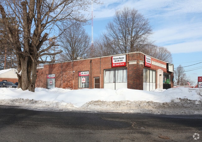
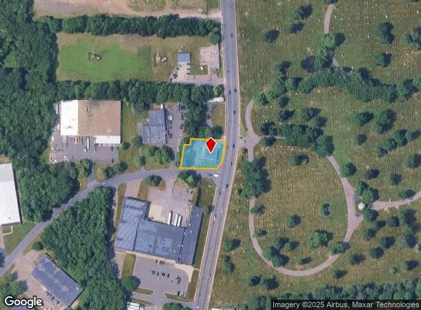
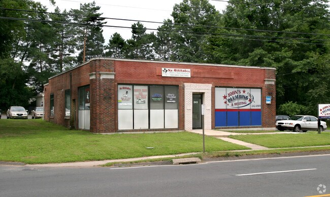
843 Blue Hills Ave, Bloomfield, CT 06002
NEARBY LISTINGS FOR SALE OR LEASE
Property Detail
843 Blue Hills Ave
BLOO-000892-000000-000002-R005204
Hartford
Commercialnec
Connecticut
X
276
09003C0362F
0.49 AC
2024
Bloomfield
2025
Hartford
471200
Hartford-West Hartford-East Hartford, CT
DEMOGRAPHICS near 843 Blue Hills Ave
1 mile
3 mile
5 mile
2024 Total Population
9,933
80,332
208,303
2029 Population
9,849
80,044
207,675
Pop Growth 2024-2029
(0.85%)
(0.36%)
(0.30%)
Average Age
39
39
39
2024 Total Households
3,083
29,914
83,452
HH Growth 2024-2029
(0.88%)
(0.38%)
(0.23%)
Median Household Inc
$62,334
$53,708
$58,287
Avg Household Size
2.60
2.40
2.30
2024 Avg HH Vehicles
2.00
1.00
1.00
Median Home Value
$162,098
$223,091
$261,579
Median Year Built
1954
1958
1957
Nearby Places
Map Layers
Map Styles
 Street
 Aerial
Transit
 Traffic
 Biking
Places
Listings with unknown addresses are not visible on the map
- Restaurants
- Banks
- Shops
- Fitness
- Groceries
PUBLIC TRANSPORTATION
COMMUTER RAIL
Hartford (Hartford Line - Hartford Line)
Drive
Walk
Distance
Hartford (Hartford Line - Hartford Line)
9 min
4.4 mi
Hartford Amtrak Station (Amtrak Hartford Line - Amtrak, Northeast Regional - Amtrak, Valley Flyer - Amtrak, Vermonter - Amtrak)
Drive
Walk
Distance
Hartford Amtrak Station (Amtrak Hartford Line - Amtrak, Northeast Regional - Amtrak, Valley Flyer - Amtrak, Vermonter - Amtrak)
9 min
4.6 mi
AIRPORT
Bradley International
Drive
Walk
Distance
Bradley International
30 min
15.0 mi
Freight Ports
Port of New Haven
Drive
Walk
Distance
Port of New Haven
60 min
43.8 mi
Nearby Properties
Address
Land Use
TOTAL SIZE
Lot Size
Zoning
Address
Land Use
TOTAL SIZE
Lot Size
Zoning
88.48 AC
R-10
Address
Land Use
TOTAL SIZE
Lot Size
Zoning
1.45 AC
CAMP
Address
Land Use
TOTAL SIZE
Lot Size
Zoning
15,871 SF
42.80 AC
PO
Address
Land Use
TOTAL SIZE
Lot Size
Zoning
584 AC
OS
Address
Land Use
TOTAL SIZE
Lot Size
Zoning
5.56 AC
CAMP
Address
Land Use
TOTAL SIZE
Lot Size
Zoning
28.02 AC
CAMP
Address
Land Use
TOTAL SIZE
Lot Size
Zoning
68.36 AC
Address
Land Use
TOTAL SIZE
Lot Size
Zoning
7.45 AC
CAMP
Address
Land Use
TOTAL SIZE
Lot Size
Zoning
227,898 SF
5.33 AC
BCD
Address
Land Use
TOTAL SIZE
Lot Size
Zoning
310,901 SF
28.75 AC
MX-2
Address
Land Use
TOTAL SIZE
Lot Size
Zoning
15.31 AC
DDZ
Address
Land Use
TOTAL SIZE
Lot Size
Zoning
197,704 SF
1.82 AC
CAMP
Address
Land Use
TOTAL SIZE
Lot Size
Zoning
40,632 SF
1.10 AC
NX-1
Address
Land Use
TOTAL SIZE
Lot Size
Zoning
772,060 SF
17.90 AC
DDZ
Address
Land Use
TOTAL SIZE
Lot Size
Zoning
23.10 AC
R-20
Address
Land Use
TOTAL SIZE
Lot Size
Zoning
11.85 AC
MX-2
Address
Land Use
TOTAL SIZE
Lot Size
Zoning
172,026 SF
11.64 AC
MX-2
Address
Land Use
TOTAL SIZE
Lot Size
Zoning
10.74 AC
ID-1
Address
Land Use
TOTAL SIZE
Lot Size
Zoning
23.07 AC
CAMP
Address
Land Use
TOTAL SIZE
Lot Size
Zoning
15.39 AC
SDD/RM
Address
Land Use
TOTAL SIZE
Lot Size
Zoning
161,576 SF
4 AC
BCD
Address
Land Use
TOTAL SIZE
Lot Size
Zoning
19.66 AC
CAMP
Address
Land Use
TOTAL SIZE
Lot Size
Zoning
82,938 SF
62.53 AC
I-1
Address
Land Use
TOTAL SIZE
Lot Size
Zoning
23.99 AC
ID-1
Address
Land Use
TOTAL SIZE
Lot Size
Zoning
77,497 SF
14.17 AC
R-20
Address
Land Use
TOTAL SIZE
Lot Size
Zoning
135,344 SF
17.85 AC
PO
Address
Land Use
TOTAL SIZE
Lot Size
Zoning
215,883 SF
10.02 AC
MX-2
Address
Land Use
TOTAL SIZE
Lot Size
Zoning
180,964 SF
32.10 AC
R-15
Address
Land Use
TOTAL SIZE
Lot Size
Zoning
356,062 SF
23.10 AC
ID-2
Address
Land Use
TOTAL SIZE
Lot Size
Zoning
39.47 AC
R-15
The World's #1 Commercial Real Estate Marketplace
Connect with us
© 2026 CoStar Group
The information above has been obtained from sources believed reliable. While we do not doubt its accuracy we have not verified it and make no guarantee, warranty or representation about it. It is your responsibility to independently confirm its accuracy and completeness. Any projections, opinions, assumptions, or estimates used are for example only and do not represent the current or future performance of the property. The value of this transaction to you depends on tax and other factors which should be evaluated by your tax, financial, and legal advisors. You and your advisors should conduct a careful, independent investigation of the property to determine to your satisfaction the suitability of the property for your needs.