Property Record
843 E Main St, Brownsburg, IN 46112
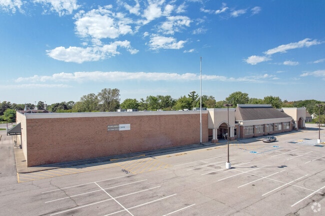

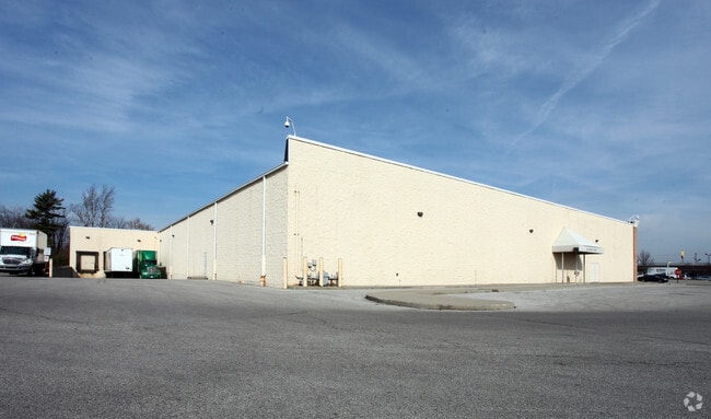
Property Detail
843 E Main St
Indianapolis-Carmel-Greenwood, IN
MUNDY DAVIS SUBDIVISION LOT 5 9.595AC
32-07-11-491-005.000-016
Hendricks
Commercialnec
Indiana
B and X Area of moderate flood hazard, usually the area between the limits of the 100-year and 500-year floods.
5
2025
9.60 AC
2025
Hendricks County
210203
Indianapolis
64,693 SF
NEARBY LISTINGS FOR SALE OR LEASE
DEMOGRAPHICS near 843 E Main St
1 mile
3 mile
5 mile
2025 Total Population
8,417
49,341
102,355
2030 Population
8,989
53,131
109,100
Pop Growth 2025-2030
+ 6.80%
+ 7.68%
+ 6.59%
Average Age
41
38
39
2025 Total Households
3,430
17,947
37,972
HH Growth 2025-2030
+ 7.17%
+ 7.93%
+ 6.63%
Median Household Inc
$81,947
$108,269
$102,500
Avg Household Size
2.40
2.70
2.60
2025 Avg HH Vehicles
2.00
2.00
2.00
Median Home Value
$233,756
$320,397
$314,167
Median Year Built
1983
2001
1998
Nearby Places
Map Layers
Map Styles
 Street
 Aerial
Layers
 Traffic
 Biking
Places
Listings with unknown addresses are not visible on the map
- Restaurants
- Banks
- Shops
- Fitness
- Groceries
PUBLIC TRANSPORTATION
AIRPORT
Indianapolis International
Drive
Walk
Distance
Indianapolis International
28 min
14.4 mi
Freight Ports
Port of Toledo
Drive
Walk
Distance
Port of Toledo
286 min
234.7 mi
SALE & LEASE HISTORY
LISTING DATE
SALE/LEASE

Apr 17, 2018
For Lease
Apr 17, 2018
For Lease
Nearby Properties
Address
Land Use
TOTAL SIZE
Lot Size
Zoning
Address
Land Use
TOTAL SIZE
Lot Size
Zoning
56.57 AC
Address
Land Use
TOTAL SIZE
Lot Size
Zoning
805,018 SF
48.20 AC
Address
Land Use
TOTAL SIZE
Lot Size
Zoning
683,528 SF
43.54 AC
Address
Land Use
TOTAL SIZE
Lot Size
Zoning
456 SF
50.27 AC
Address
Land Use
TOTAL SIZE
Lot Size
Zoning
773,129 SF
36.12 AC
Address
Land Use
TOTAL SIZE
Lot Size
Zoning
25,031 SF
20.30 AC
Address
Land Use
TOTAL SIZE
Lot Size
Zoning
Address
Land Use
TOTAL SIZE
Lot Size
Zoning
26,460 SF
24.91 AC
Address
Land Use
TOTAL SIZE
Lot Size
Zoning
32.50 AC
Address
Land Use
TOTAL SIZE
Lot Size
Zoning
244,838 SF
3.01 AC
Address
Land Use
TOTAL SIZE
Lot Size
Zoning
21.15 AC
Address
Land Use
TOTAL SIZE
Lot Size
Zoning
225,712 SF
2.22 AC
Address
Land Use
TOTAL SIZE
Lot Size
Zoning
3,712 SF
17.58 AC
Address
Land Use
TOTAL SIZE
Lot Size
Zoning
526,200 SF
28.31 AC
Address
Land Use
TOTAL SIZE
Lot Size
Zoning
29.46 AC
Address
Land Use
TOTAL SIZE
Lot Size
Zoning
405,824 SF
32.37 AC
Address
Land Use
TOTAL SIZE
Lot Size
Zoning
24.15 AC
Address
Land Use
TOTAL SIZE
Lot Size
Zoning
396,768 SF
20.88 AC
Address
Land Use
TOTAL SIZE
Lot Size
Zoning
86,706 SF
19.47 AC
Address
Land Use
TOTAL SIZE
Lot Size
Zoning
Address
Land Use
TOTAL SIZE
Lot Size
Zoning
Address
Land Use
TOTAL SIZE
Lot Size
Zoning
204,358 SF
12.50 AC
Address
Land Use
TOTAL SIZE
Lot Size
Zoning
100,108 SF
50.12 AC
Address
Land Use
TOTAL SIZE
Lot Size
Zoning
80,046 SF
13.65 AC
Address
Land Use
TOTAL SIZE
Lot Size
Zoning
20.46 AC
Address
Land Use
TOTAL SIZE
Lot Size
Zoning
7,568 SF
14.47 AC
Address
Land Use
TOTAL SIZE
Lot Size
Zoning
Address
Land Use
TOTAL SIZE
Lot Size
Zoning
99,038 SF
7.09 AC
Address
Land Use
TOTAL SIZE
Lot Size
Zoning
17,500 SF
33.72 AC
Address
Land Use
TOTAL SIZE
Lot Size
Zoning
The World's #1 Commercial Real Estate Marketplace
Connect with us
© 2026 CoStar Group
The information above has been obtained from sources believed reliable. While we do not doubt its accuracy we have not verified it and make no guarantee, warranty or representation about it. It is your responsibility to independently confirm its accuracy and completeness. Any projections, opinions, assumptions, or estimates used are for example only and do not represent the current or future performance of the property. The value of this transaction to you depends on tax and other factors which should be evaluated by your tax, financial, and legal advisors. You and your advisors should conduct a careful, independent investigation of the property to determine to your satisfaction the suitability of the property for your needs.