Property Record
843 Fremont St, Lancaster, PA 17603


NEARBY LISTINGS FOR SALE OR LEASE
-
-
View all Lancaster listings for sale on LoopNet.com
Property Detail
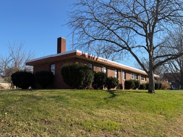
843 Fremont St
338-89146-0-0000
843 FREMONT ST
Policefirecivildefense
Lancaster
X
Pennsylvania
42071C0364F
4
2024
0.61 AC
2025
Lancaster County
001200
Philadelphia
4,232 SF
Lancaster, PA
DEMOGRAPHICS near 843 Fremont St
1 Mile
3 Mile
5 Mile
2024 Total Population
34,366
108,897
183,714
2029 Population
34,776
110,378
186,747
Pop Growth 2024-2029
+ 1.19%
+ 1.36%
+ 1.65%
Average Age
37
39
40
2024 Total Households
13,188
41,333
70,968
HH Growth 2024-2029
+ 1.30%
+ 1.33%
+ 1.61%
Median Household Inc
$60,213
$69,979
$76,942
Avg Household Size
2.40
2.40
2.40
2024 Avg HH Vehicles
1.00
2.00
2.00
Median Home Value
$200,093
$253,632
$292,133
Median Year Built
1948
1954
1970
Nearby Places
Map Layers
Map Styles
 Street
 Aerial
- Restaurants
- Banks
- Shops
- Fitness
- Groceries
PUBLIC TRANSPORTATION
COMMUTER RAIL
Lancaster (Keystone Service - Amtrak, Pennsylvanian - Amtrak)
DRIVE
WALK
Distance
Lancaster (Keystone Service - Amtrak, Pennsylvanian - Amtrak)
7 min
2.4 mi
AIRPORT
Harrisburg International
DRIVE
WALK
Distance
Harrisburg International
46 min
33.4 mi
Freight Ports
Port of Wilmington, RI
DRIVE
WALK
Distance
Port of Wilmington, RI
94 min
64.8 mi
Nearby Properties
Address
Land Use
TOTAL SIZE
Lot Size
Zoning
Address
Land Use
TOTAL SIZE
Lot Size
Zoning
1,603,151 SF
104.89 AC
C3
Address
Land Use
TOTAL SIZE
Lot Size
Zoning
1,120,221 SF
8.40 AC
Address
Land Use
TOTAL SIZE
Lot Size
Zoning
2,008,418 SF
76.74 AC
Address
Land Use
TOTAL SIZE
Lot Size
Zoning
871,695 SF
69.40 AC
R2
Address
Land Use
TOTAL SIZE
Lot Size
Zoning
206,666 SF
1 AC
CB1
Address
Land Use
TOTAL SIZE
Lot Size
Zoning
712,737 SF
52.50 AC
R2
Address
Land Use
TOTAL SIZE
Lot Size
Zoning
269,860 SF
0.90 AC
CB1
Address
Land Use
TOTAL SIZE
Lot Size
Zoning
610,085 SF
57.70 AC
R1A
Address
Land Use
TOTAL SIZE
Lot Size
Zoning
315,373 SF
4.73 AC
DF
Address
Land Use
TOTAL SIZE
Lot Size
Zoning
642,651 SF
2.16 AC
CA
Address
Land Use
TOTAL SIZE
Lot Size
Zoning
308,727 SF
11.37 AC
Address
Land Use
TOTAL SIZE
Lot Size
Zoning
307,696 SF
29 AC
R1
Address
Land Use
TOTAL SIZE
Lot Size
Zoning
178,234 SF
0.78 AC
CB
Address
Land Use
TOTAL SIZE
Lot Size
Zoning
288,628 SF
27.80 AC
R1A
Address
Land Use
TOTAL SIZE
Lot Size
Zoning
99,894 SF
21.88 AC
Address
Land Use
TOTAL SIZE
Lot Size
Zoning
35,920 SF
35.68 AC
Address
Land Use
TOTAL SIZE
Lot Size
Zoning
234,386 SF
15.30 AC
MU
Address
Land Use
TOTAL SIZE
Lot Size
Zoning
135,998 SF
28.64 AC
HR
Address
Land Use
TOTAL SIZE
Lot Size
Zoning
254,079 SF
21.54 AC
Address
Land Use
TOTAL SIZE
Lot Size
Zoning
234,681 SF
7.50 AC
MU
Address
Land Use
TOTAL SIZE
Lot Size
Zoning
203,942 SF
21.22 AC
B-4
Address
Land Use
TOTAL SIZE
Lot Size
Zoning
246,742 SF
12.49 AC
B-4
Address
Land Use
TOTAL SIZE
Lot Size
Zoning
125,073 SF
19.07 AC
I
Address
Land Use
TOTAL SIZE
Lot Size
Zoning
128,939 SF
27.39 AC
Address
Land Use
TOTAL SIZE
Lot Size
Zoning
101,558 SF
28.14 AC
AH
Address
Land Use
TOTAL SIZE
Lot Size
Zoning
199,107 SF
26.20 AC
CC
Address
Land Use
TOTAL SIZE
Lot Size
Zoning
87,502 SF
11.69 AC
MU
Address
Land Use
TOTAL SIZE
Lot Size
Zoning
131,294 SF
11.14 AC
B-4
Address
Land Use
TOTAL SIZE
Lot Size
Zoning
256,905 SF
1.57 AC
CB1
Address
Land Use
TOTAL SIZE
Lot Size
Zoning
216,206 SF
17.88 AC
The World's #1 Commercial Real Estate Marketplace
Connect with us
© 2026 CoStar Group
The information above has been obtained from sources believed reliable. While we do not doubt its accuracy we have not verified it and make no guarantee, warranty or representation about it. It is your responsibility to independently confirm its accuracy and completeness. Any projections, opinions, assumptions, or estimates used are for example only and do not represent the current or future performance of the property. The value of this transaction to you depends on tax and other factors which should be evaluated by your tax, financial, and legal advisors. You and your advisors should conduct a careful, independent investigation of the property to determine to your satisfaction the suitability of the property for your needs.