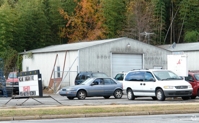
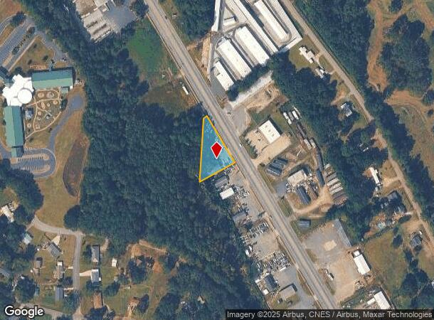
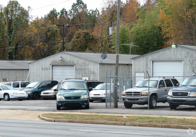
Property Record
843 Highway 28 Byp, Anderson, SC 29624
NEARBY LISTINGS FOR SALE OR LEASE
Property Detail
843 Highway 28 Byp
124-03-04-006
CP S-29/8-A F 00272D 00192 HWY 28 BY-PASS
Warehouse
Anderson
X
South Carolina
45007C0381E
1.20 AC
2025
Outlying Anderson Co
2024
Greenville/Spartanburg
012002
Greenville-Anderson-Mauldin, SC
1,800 SF
DEMOGRAPHICS near 843 Highway 28 Byp
1 Mile
3 Mile
5 Mile
2024 Total Population
3,550
36,686
72,219
2029 Population
3,822
39,639
77,510
Pop Growth 2024-2029
+ 7.66%
+ 8.05%
+ 7.33%
Average Age
40
39
40
2024 Total Households
1,533
14,910
29,373
HH Growth 2024-2029
+ 7.63%
+ 8.20%
+ 7.42%
Median Household Inc
$35,486
$38,449
$44,565
Avg Household Size
2.30
2.30
2.30
2024 Avg HH Vehicles
1.00
2.00
2.00
Median Home Value
$92,287
$117,290
$152,814
Median Year Built
1979
1974
1980
Nearby Places
Map Layers
Map Styles
 Street
 Aerial
- Restaurants
- Banks
- Shops
- Fitness
- Groceries
PUBLIC TRANSPORTATION
AIRPORT
Greenville Spartanburg International
DRIVE
WALK
Distance
Greenville Spartanburg International
56 min
43.8 mi
Nearby Properties
Address
Land Use
TOTAL SIZE
Lot Size
Zoning
Address
Land Use
TOTAL SIZE
Lot Size
Zoning
2,027 SF
12.16 AC
Address
Land Use
TOTAL SIZE
Lot Size
Zoning
183,500 SF
19.79 AC
Address
Land Use
TOTAL SIZE
Lot Size
Zoning
27,441 SF
5.49 AC
Address
Land Use
TOTAL SIZE
Lot Size
Zoning
121,232 SF
19.72 AC
Address
Land Use
TOTAL SIZE
Lot Size
Zoning
45,014 SF
0.29 AC
Address
Land Use
TOTAL SIZE
Lot Size
Zoning
61,281 SF
0.74 AC
Address
Land Use
TOTAL SIZE
Lot Size
Zoning
75.85 AC
Address
Land Use
TOTAL SIZE
Lot Size
Zoning
9,550 SF
3 AC
Address
Land Use
TOTAL SIZE
Lot Size
Zoning
3,233 SF
9.93 AC
Address
Land Use
TOTAL SIZE
Lot Size
Zoning
150,719 SF
31.62 AC
Address
Land Use
TOTAL SIZE
Lot Size
Zoning
0.74 AC
Address
Land Use
TOTAL SIZE
Lot Size
Zoning
110,140 SF
6 AC
Address
Land Use
TOTAL SIZE
Lot Size
Zoning
149,148 SF
16.87 AC
Address
Land Use
TOTAL SIZE
Lot Size
Zoning
30,250 SF
2 AC
Address
Land Use
TOTAL SIZE
Lot Size
Zoning
6,325 SF
4.84 AC
Address
Land Use
TOTAL SIZE
Lot Size
Zoning
24.87 AC
Address
Land Use
TOTAL SIZE
Lot Size
Zoning
89.99 AC
Address
Land Use
TOTAL SIZE
Lot Size
Zoning
9,406 SF
7.92 AC
Address
Land Use
TOTAL SIZE
Lot Size
Zoning
14,693 SF
2.02 AC
Address
Land Use
TOTAL SIZE
Lot Size
Zoning
44,568 SF
2.47 AC
Address
Land Use
TOTAL SIZE
Lot Size
Zoning
1,940 SF
5.70 AC
Address
Land Use
TOTAL SIZE
Lot Size
Zoning
14,656 SF
1.93 AC
Address
Land Use
TOTAL SIZE
Lot Size
Zoning
40,036 SF
8.10 AC
Address
Land Use
TOTAL SIZE
Lot Size
Zoning
44,358 SF
6.25 AC
Address
Land Use
TOTAL SIZE
Lot Size
Zoning
14,806 SF
2 AC
Address
Land Use
TOTAL SIZE
Lot Size
Zoning
22,220 SF
5.06 AC
Address
Land Use
TOTAL SIZE
Lot Size
Zoning
60,762 SF
7.09 AC
Address
Land Use
TOTAL SIZE
Lot Size
Zoning
Address
Land Use
TOTAL SIZE
Lot Size
Zoning
733 SF
2.80 AC
The World's #1 Commercial Real Estate Marketplace
Connect with us
© 2025 CoStar Group
The information above has been obtained from sources believed reliable. While we do not doubt its accuracy we have not verified it and make no guarantee, warranty or representation about it. It is your responsibility to independently confirm its accuracy and completeness. Any projections, opinions, assumptions, or estimates used are for example only and do not represent the current or future performance of the property. The value of this transaction to you depends on tax and other factors which should be evaluated by your tax, financial, and legal advisors. You and your advisors should conduct a careful, independent investigation of the property to determine to your satisfaction the suitability of the property for your needs.