Property Record
8431 Racine Ave, Waterford, WI 53185


NEARBY LISTINGS FOR SALE OR LEASE
-
-
View all Waterford listings for sale on LoopNet.com
Property Detail
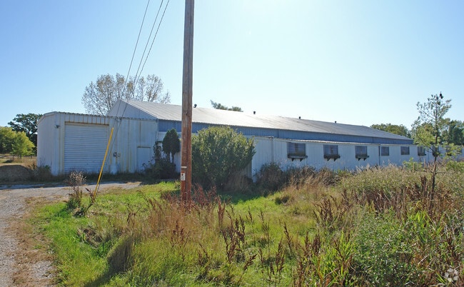
8431 Racine Ave
Racine, WI
Cerified Survey Map No 9740
010-042005021000
PT S1/2 COM 2481N S1/4 COR W61 NW153 E82 E1325 S641 W1000 N505 W325 TO POB -N33 **TOTAL ACRES** 16.00
Commercialnec
Racine
X
Wisconsin
55101C0033E
16 AC
2024
Racine West
2024
Milwaukee/Madison
002001
DEMOGRAPHICS near 8431 Racine Ave
1 Mile
3 Mile
5 Mile
2024 Total Population
2,479
9,241
23,954
2029 Population
2,454
9,197
24,090
Pop Growth 2024-2029
(1.01%)
(0.48%)
+ 0.57%
Average Age
43
43
43
2024 Total Households
954
3,578
9,236
HH Growth 2024-2029
(1.15%)
(0.53%)
+ 0.48%
Median Household Inc
$98,050
$105,825
$109,735
Avg Household Size
2.60
2.50
2.60
2024 Avg HH Vehicles
2.00
2.00
2.00
Median Home Value
$348,504
$359,660
$367,908
Median Year Built
1979
1984
1987
Nearby Places
Map Layers
Map Styles
 Street
 Aerial
- Restaurants
- Banks
- Shops
- Fitness
- Groceries
PUBLIC TRANSPORTATION
AIRPORT
General Mitchell International
DRIVE
WALK
Distance
General Mitchell International
32 min
17.6 mi
Freight Ports
Port Milwaukee
DRIVE
WALK
Distance
Port Milwaukee
32 min
20.4 mi
Nearby Properties
Address
Land Use
TOTAL SIZE
Lot Size
Zoning
Address
Land Use
TOTAL SIZE
Lot Size
Zoning
Address
Land Use
TOTAL SIZE
Lot Size
Zoning
Address
Land Use
TOTAL SIZE
Lot Size
Zoning
3.04 AC
Address
Land Use
TOTAL SIZE
Lot Size
Zoning
1.50 AC
Address
Land Use
TOTAL SIZE
Lot Size
Zoning
1.10 AC
Address
Land Use
TOTAL SIZE
Lot Size
Zoning
Address
Land Use
TOTAL SIZE
Lot Size
Zoning
Address
Land Use
TOTAL SIZE
Lot Size
Zoning
0.32 AC
Address
Land Use
TOTAL SIZE
Lot Size
Zoning
39.60 AC
Address
Land Use
TOTAL SIZE
Lot Size
Zoning
0.64 AC
Address
Land Use
TOTAL SIZE
Lot Size
Zoning
35.79 AC
Address
Land Use
TOTAL SIZE
Lot Size
Zoning
0.64 AC
Address
Land Use
TOTAL SIZE
Lot Size
Zoning
0.42 AC
Address
Land Use
TOTAL SIZE
Lot Size
Zoning
0.64 AC
Address
Land Use
TOTAL SIZE
Lot Size
Zoning
0.64 AC
Address
Land Use
TOTAL SIZE
Lot Size
Zoning
0.64 AC
Address
Land Use
TOTAL SIZE
Lot Size
Zoning
Address
Land Use
TOTAL SIZE
Lot Size
Zoning
18.44 AC
Address
Land Use
TOTAL SIZE
Lot Size
Zoning
0.91 AC
Address
Land Use
TOTAL SIZE
Lot Size
Zoning
Address
Land Use
TOTAL SIZE
Lot Size
Zoning
0.35 AC
Address
Land Use
TOTAL SIZE
Lot Size
Zoning
10.27 AC
Address
Land Use
TOTAL SIZE
Lot Size
Zoning
7,604 SF
33.47 AC
Address
Land Use
TOTAL SIZE
Lot Size
Zoning
0.70 AC
Address
Land Use
TOTAL SIZE
Lot Size
Zoning
1.67 AC
Address
Land Use
TOTAL SIZE
Lot Size
Zoning
5.43 AC
Address
Land Use
TOTAL SIZE
Lot Size
Zoning
37.14 AC
Address
Land Use
TOTAL SIZE
Lot Size
Zoning
18.61 AC
Address
Land Use
TOTAL SIZE
Lot Size
Zoning
1.07 AC
The World's #1 Commercial Real Estate Marketplace
Connect with us
© 2025 CoStar Group
The information above has been obtained from sources believed reliable. While we do not doubt its accuracy we have not verified it and make no guarantee, warranty or representation about it. It is your responsibility to independently confirm its accuracy and completeness. Any projections, opinions, assumptions, or estimates used are for example only and do not represent the current or future performance of the property. The value of this transaction to you depends on tax and other factors which should be evaluated by your tax, financial, and legal advisors. You and your advisors should conduct a careful, independent investigation of the property to determine to your satisfaction the suitability of the property for your needs.