Property Record
8435 Whittaker Rd, Ypsilanti, MI 48197
NEARBY LISTINGS FOR SALE OR LEASE
-
-
View all Ypsilanti listings for sale on LoopNet.com
Property Detail
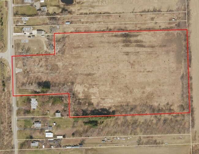
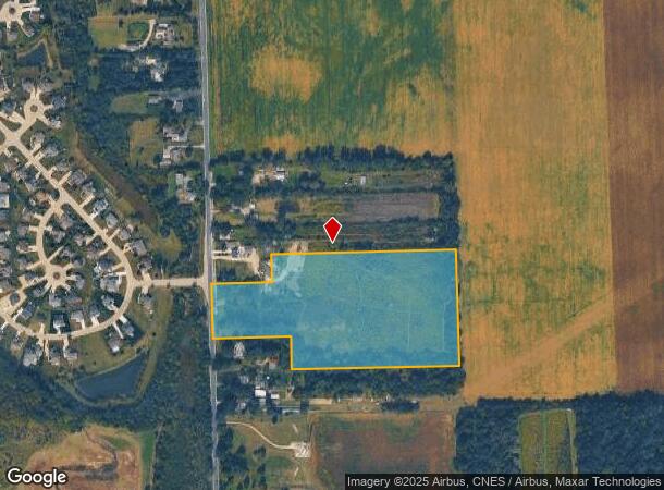
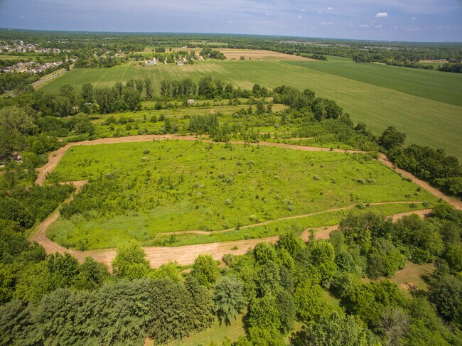
8435 Whittaker Rd
20-03-200-027
OWNER REQUEST ****FROM 2003200025 08/15/95 AU 3-7A-2B REMAINDER COM AT W 1/4 COR SEC 3, TH N 407.94 FT TO POB, TH N 293.76
Agriculturalland
Washtenaw
AE
Michigan
26161C0440E
15.83 AC
2025
Washtenaw E of 23
2025
Detroit
420000
Ann Arbor, MI
DEMOGRAPHICS near 8435 Whittaker Rd
1 Mile
3 Mile
5 Mile
2024 Total Population
1,626
21,494
60,412
2029 Population
1,596
21,188
59,704
Pop Growth 2024-2029
(1.85%)
(1.42%)
(1.17%)
Average Age
36
38
39
2024 Total Households
542
7,634
22,828
HH Growth 2024-2029
(1.85%)
(1.43%)
(1.27%)
Median Household Inc
$114,642
$99,561
$71,125
Avg Household Size
2.90
2.80
2.50
2024 Avg HH Vehicles
2.00
2.00
2.00
Median Home Value
$264,808
$248,460
$221,083
Median Year Built
2003
1997
1980
Nearby Places
Map Layers
Map Styles
 Street
 Aerial
- Restaurants
- Banks
- Shops
- Fitness
- Groceries
PUBLIC TRANSPORTATION
AIRPORT
Detroit Metro Wayne County
DRIVE
WALK
Distance
Detroit Metro Wayne County
28 min
21.1 mi
Freight Ports
Port of Toledo
DRIVE
WALK
Distance
Port of Toledo
71 min
53.7 mi
SALE & LEASE HISTORY
LISTING DATE
SALE/LEASE

Jul 11, 2022
For Sale
Nearby Properties
Address
Land Use
TOTAL SIZE
Lot Size
Zoning
Address
Land Use
TOTAL SIZE
Lot Size
Zoning
97.69 AC
Address
Land Use
TOTAL SIZE
Lot Size
Zoning
12.02 AC
Address
Land Use
TOTAL SIZE
Lot Size
Zoning
1,744 SF
41.75 AC
BI
Address
Land Use
TOTAL SIZE
Lot Size
Zoning
12.38 AC
RV
Address
Land Use
TOTAL SIZE
Lot Size
Zoning
16,414 SF
7.66 AC
BA
Address
Land Use
TOTAL SIZE
Lot Size
Zoning
6,000 SF
15 AC
DI
Address
Land Use
TOTAL SIZE
Lot Size
Zoning
11,160 SF
2.09 AC
BI
Address
Land Use
TOTAL SIZE
Lot Size
Zoning
20 AC
DI
Address
Land Use
TOTAL SIZE
Lot Size
Zoning
5,515 SF
89.67 AC
BLANK
Address
Land Use
TOTAL SIZE
Lot Size
Zoning
45,550 SF
4.91 AC
Address
Land Use
TOTAL SIZE
Lot Size
Zoning
11,000 SF
35.61 AC
Address
Land Use
TOTAL SIZE
Lot Size
Zoning
5,684 SF
141.89 AC
Address
Land Use
TOTAL SIZE
Lot Size
Zoning
69.94 AC
BI
Address
Land Use
TOTAL SIZE
Lot Size
Zoning
280.24 AC
BLANK
Address
Land Use
TOTAL SIZE
Lot Size
Zoning
231.77 AC
BLANK
Address
Land Use
TOTAL SIZE
Lot Size
Zoning
31,329 SF
4.50 AC
BI
Address
Land Use
TOTAL SIZE
Lot Size
Zoning
11,894 SF
110 AC
BLANK
Address
Land Use
TOTAL SIZE
Lot Size
Zoning
6.02 AC
Address
Land Use
TOTAL SIZE
Lot Size
Zoning
81.80 AC
BLANK
Address
Land Use
TOTAL SIZE
Lot Size
Zoning
6,670 SF
2.43 AC
BLANK
Address
Land Use
TOTAL SIZE
Lot Size
Zoning
14,250 SF
2.41 AC
Address
Land Use
TOTAL SIZE
Lot Size
Zoning
8,752 SF
2.71 AC
Address
Land Use
TOTAL SIZE
Lot Size
Zoning
6,462 SF
4.99 AC
BI
Address
Land Use
TOTAL SIZE
Lot Size
Zoning
25,292 SF
20.54 AC
Address
Land Use
TOTAL SIZE
Lot Size
Zoning
9,480 SF
2.67 AC
TE
Address
Land Use
TOTAL SIZE
Lot Size
Zoning
1,568 SF
10.10 AC
BI
Address
Land Use
TOTAL SIZE
Lot Size
Zoning
7,848 SF
6.09 AC
BI
Address
Land Use
TOTAL SIZE
Lot Size
Zoning
7,773 SF
1.26 AC
BI
Address
Land Use
TOTAL SIZE
Lot Size
Zoning
2,188 SF
80 AC
FI
Address
Land Use
TOTAL SIZE
Lot Size
Zoning
174.46 AC
BLANK
The World's #1 Commercial Real Estate Marketplace
Connect with us
© 2025 CoStar Group
The information above has been obtained from sources believed reliable. While we do not doubt its accuracy we have not verified it and make no guarantee, warranty or representation about it. It is your responsibility to independently confirm its accuracy and completeness. Any projections, opinions, assumptions, or estimates used are for example only and do not represent the current or future performance of the property. The value of this transaction to you depends on tax and other factors which should be evaluated by your tax, financial, and legal advisors. You and your advisors should conduct a careful, independent investigation of the property to determine to your satisfaction the suitability of the property for your needs.