Property Record
844 Providence Rd, Chesapeake, VA 23325
NEARBY LISTINGS FOR SALE OR LEASE
Property Detail
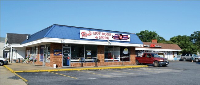
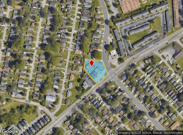
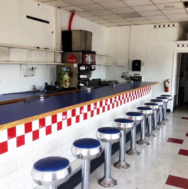
844 Providence Rd
0202011000001
Washington - Commercial
Storebuilding
PT A RESUB 2 BK 79&11 THRU 15 BK 48 N HGLDS SUB 1
X
Chesapeake
5100340017D
Virginia
2024
0.91 AC
2025
College Park
020003
Hampton Roads
4,200 SF
Virginia Beach-Norfolk-Newport News, VA-NC
DEMOGRAPHICS near 844 Providence Rd
1 Mile
3 Mile
5 Mile
2024 Total Population
15,533
100,875
280,722
2029 Population
15,917
102,483
281,512
Pop Growth 2024-2029
+ 2.47%
+ 1.59%
+ 0.28%
Average Age
39
39
38
2024 Total Households
6,269
39,989
110,473
HH Growth 2024-2029
+ 2.25%
+ 1.55%
+ 0.15%
Median Household Inc
$71,722
$66,626
$67,812
Avg Household Size
2.40
2.40
2.40
2024 Avg HH Vehicles
2.00
2.00
2.00
Median Home Value
$227,992
$246,700
$253,709
Median Year Built
1978
1978
1980
Nearby Places
Map Layers
Map Styles
 Street
 Aerial
- Restaurants
- Banks
- Shops
- Fitness
- Groceries
PUBLIC TRANSPORTATION
COMMUTER RAIL
Norfolk (Northeast Regional - Amtrak)
DRIVE
WALK
Distance
Norfolk (Northeast Regional - Amtrak)
10 min
5.0 mi
AIRPORT
Norfolk International
DRIVE
WALK
Distance
Norfolk International
15 min
7.8 mi
Newport News/Williamsburg International
DRIVE
WALK
Distance
Newport News/Williamsburg International
51 min
33.7 mi
Freight Ports
Virginia Port Authority - Portsmouth
DRIVE
WALK
Distance
Virginia Port Authority - Portsmouth
21 min
10.0 mi
SALE & LEASE HISTORY
LISTING DATE
SALE/LEASE

Aug 23, 2017
For Lease
Nearby Properties
Address
Land Use
TOTAL SIZE
Lot Size
Zoning
Address
Land Use
TOTAL SIZE
Lot Size
Zoning
405,992 SF
40.22 AC
PUD: PLANN
Address
Land Use
TOTAL SIZE
Lot Size
Zoning
439,870 SF
24.90 AC
PUD: PLANN
Address
Land Use
TOTAL SIZE
Lot Size
Zoning
743,121 SF
57.42 AC
RMF1: MULT
Address
Land Use
TOTAL SIZE
Lot Size
Zoning
689,954 SF
63.25 AC
Address
Land Use
TOTAL SIZE
Lot Size
Zoning
358,908 SF
22.21 AC
MULTI: MUL
Address
Land Use
TOTAL SIZE
Lot Size
Zoning
1 SF
20.80 AC
A18
Address
Land Use
TOTAL SIZE
Lot Size
Zoning
17.04 AC
A24
Address
Land Use
TOTAL SIZE
Lot Size
Zoning
209,403 SF
2.81 AC
PUD: PLANN
Address
Land Use
TOTAL SIZE
Lot Size
Zoning
95,354 SF
39.53 AC
B2: GENERA
Address
Land Use
TOTAL SIZE
Lot Size
Zoning
264,213 SF
17.59 AC
PUD: PLANN
Address
Land Use
TOTAL SIZE
Lot Size
Zoning
Address
Land Use
TOTAL SIZE
Lot Size
Zoning
252,524 SF
20 AC
R8S: RESID
Address
Land Use
TOTAL SIZE
Lot Size
Zoning
188,152 SF
16.93 AC
Address
Land Use
TOTAL SIZE
Lot Size
Zoning
168,391 SF
28.39 AC
B2: GENERA
Address
Land Use
TOTAL SIZE
Lot Size
Zoning
32,163 SF
17.59 AC
MULTI: MUL
Address
Land Use
TOTAL SIZE
Lot Size
Zoning
270,962 SF
6.17 AC
MXD-U: MIX
Address
Land Use
TOTAL SIZE
Lot Size
Zoning
262,920 SF
20.94 AC
PUD: PLANN
Address
Land Use
TOTAL SIZE
Lot Size
Zoning
366,720 SF
23 AC
RMF1: MULT
Address
Land Use
TOTAL SIZE
Lot Size
Zoning
303,401 SF
12.98 AC
A24
Address
Land Use
TOTAL SIZE
Lot Size
Zoning
401,302 SF
18.74 AC
M2: GENERA
Address
Land Use
TOTAL SIZE
Lot Size
Zoning
128,596 SF
16.91 AC
M2: GENERA
Address
Land Use
TOTAL SIZE
Lot Size
Zoning
142,656 SF
22.17 AC
RMF1: MULT
Address
Land Use
TOTAL SIZE
Lot Size
Zoning
287,268 SF
83.63 AC
MULTI: MUL
Address
Land Use
TOTAL SIZE
Lot Size
Zoning
240,547 SF
6.18 AC
PUD: PLANN
Address
Land Use
TOTAL SIZE
Lot Size
Zoning
2 SF
13.12 AC
A24
Address
Land Use
TOTAL SIZE
Lot Size
Zoning
132,309 SF
18.59 AC
O2
Address
Land Use
TOTAL SIZE
Lot Size
Zoning
294,457 SF
47.04 AC
R75
Address
Land Use
TOTAL SIZE
Lot Size
Zoning
330,353 SF
17.61 AC
O2
Address
Land Use
TOTAL SIZE
Lot Size
Zoning
162,291 SF
2.98 AC
PUD: PLANN
Address
Land Use
TOTAL SIZE
Lot Size
Zoning
193,950 SF
10.68 AC
A24
The World's #1 Commercial Real Estate Marketplace
Connect with us
© 2025 CoStar Group
The information above has been obtained from sources believed reliable. While we do not doubt its accuracy we have not verified it and make no guarantee, warranty or representation about it. It is your responsibility to independently confirm its accuracy and completeness. Any projections, opinions, assumptions, or estimates used are for example only and do not represent the current or future performance of the property. The value of this transaction to you depends on tax and other factors which should be evaluated by your tax, financial, and legal advisors. You and your advisors should conduct a careful, independent investigation of the property to determine to your satisfaction the suitability of the property for your needs.