Property Record
844 Haverford Ave, Pacific Palisades, CA 90272


NEARBY LISTINGS FOR SALE OR LEASE
Property Detail
844 Haverford Ave
Los Angeles-Long Beach-Glendale, CA
9300
4412-004-009
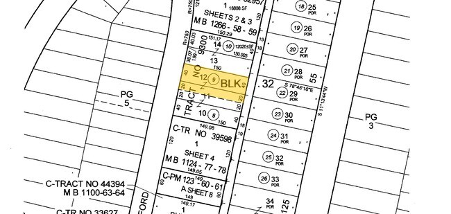
TRACT # 9300 NE 20 FT OF LOT 11 AND ALL OF LOT 12 BLK 32
Multifamilydwelling
Los Angeles
X
California
06037C1567G
11,12
2024
0.21 AC
2025
Pacific Palisades
262706
Los Angeles
7,857 SF
DEMOGRAPHICS near 844 Haverford Ave
1 Mile
3 Mile
5 Mile
2024 Total Population
12,615
80,154
233,991
2029 Population
12,290
78,750
230,208
Pop Growth 2024-2029
(2.58%)
(1.75%)
(1.62%)
Average Age
45
45
41
2024 Total Households
4,916
37,583
109,760
HH Growth 2024-2029
(2.73%)
(1.73%)
(1.72%)
Median Household Inc
$195,753
$140,244
$110,920
Avg Household Size
2.50
2.10
2.00
2024 Avg HH Vehicles
2.00
2.00
1.00
Median Home Value
$1,141,372
$1,135,025
$1,113,740
Median Year Built
1961
1967
1970
Nearby Places
Map Layers
Map Styles
 Street
 Aerial
- Restaurants
- Banks
- Shops
- Fitness
- Groceries
PUBLIC TRANSPORTATION
AIRPORT
Los Angeles International
DRIVE
WALK
Distance
Los Angeles International
24 min
12.4 mi
Bob Hope
DRIVE
WALK
Distance
Bob Hope
37 min
21.5 mi
Long Beach (Daugherty Field)
DRIVE
WALK
Distance
Long Beach (Daugherty Field)
44 min
32.6 mi
Freight Ports
Port of Los Angeles
DRIVE
WALK
Distance
Port of Los Angeles
51 min
35.8 mi
Nearby Properties
Address
Land Use
TOTAL SIZE
Lot Size
Zoning
Address
Land Use
TOTAL SIZE
Lot Size
Zoning
486,993 SF
8.31 AC
SMCP3-CP5*
Address
Land Use
TOTAL SIZE
Lot Size
Zoning
193,462 SF
64.72 AC
LAA1
Address
Land Use
TOTAL SIZE
Lot Size
Zoning
197,520 SF
0.81 AC
SMRVC*
Address
Land Use
TOTAL SIZE
Lot Size
Zoning
475,736 SF
4.94 AC
SMC3C*
Address
Land Use
TOTAL SIZE
Lot Size
Zoning
172,273 SF
1.21 AC
SMC3
Address
Land Use
TOTAL SIZE
Lot Size
Zoning
102,157 SF
0.71 AC
SMRVC*
Address
Land Use
TOTAL SIZE
Lot Size
Zoning
126,282 SF
0.86 AC
SMC3-R3A*
Address
Land Use
TOTAL SIZE
Lot Size
Zoning
89,748 SF
2.13 AC
Address
Land Use
TOTAL SIZE
Lot Size
Zoning
285,379 SF
0.56 AC
SMRVC*
Address
Land Use
TOTAL SIZE
Lot Size
Zoning
102,157 SF
0.50 AC
SMBSC4*
Address
Land Use
TOTAL SIZE
Lot Size
Zoning
92,689 SF
163.94 AC
LAA1
Address
Land Use
TOTAL SIZE
Lot Size
Zoning
257,362 SF
4.38 AC
SMRVC*
Address
Land Use
TOTAL SIZE
Lot Size
Zoning
332,063 SF
1.55 AC
SMC3C*
Address
Land Use
TOTAL SIZE
Lot Size
Zoning
109,636 SF
0.92 AC
SMC3-RVC*
Address
Land Use
TOTAL SIZE
Lot Size
Zoning
133,090 SF
0.86 AC
SMC3*
Address
Land Use
TOTAL SIZE
Lot Size
Zoning
87,927 SF
0.52 AC
SMC3C*
Address
Land Use
TOTAL SIZE
Lot Size
Zoning
237,378 SF
0.34 AC
SMC3*
Address
Land Use
TOTAL SIZE
Lot Size
Zoning
37,989 SF
1 AC
SMR4*
Address
Land Use
TOTAL SIZE
Lot Size
Zoning
75,095 SF
0.52 AC
SMC3C*
Address
Land Use
TOTAL SIZE
Lot Size
Zoning
216,456 SF
1.55 AC
SMR3A-C3-R
Address
Land Use
TOTAL SIZE
Lot Size
Zoning
93,900 SF
1.73 AC
LAC2
Address
Land Use
TOTAL SIZE
Lot Size
Zoning
10,352 SF
0.26 AC
SMBSC1*
Address
Land Use
TOTAL SIZE
Lot Size
Zoning
49,776 SF
0.33 AC
SMRVC*
Address
Land Use
TOTAL SIZE
Lot Size
Zoning
6,892 SF
2.78 AC
LARE20
Address
Land Use
TOTAL SIZE
Lot Size
Zoning
201,150 SF
0.69 AC
SMBSC1*
Address
Land Use
TOTAL SIZE
Lot Size
Zoning
48,863 SF
0.34 AC
SMC3*
Address
Land Use
TOTAL SIZE
Lot Size
Zoning
39,474 SF
0.35 AC
SMR4*
Address
Land Use
TOTAL SIZE
Lot Size
Zoning
67,934 SF
0.52 AC
SMC3C*
Address
Land Use
TOTAL SIZE
Lot Size
Zoning
47,252 SF
0.36 AC
SMBSC4*
The World's #1 Commercial Real Estate Marketplace
Connect with us
© 2026 CoStar Group
The information above has been obtained from sources believed reliable. While we do not doubt its accuracy we have not verified it and make no guarantee, warranty or representation about it. It is your responsibility to independently confirm its accuracy and completeness. Any projections, opinions, assumptions, or estimates used are for example only and do not represent the current or future performance of the property. The value of this transaction to you depends on tax and other factors which should be evaluated by your tax, financial, and legal advisors. You and your advisors should conduct a careful, independent investigation of the property to determine to your satisfaction the suitability of the property for your needs.