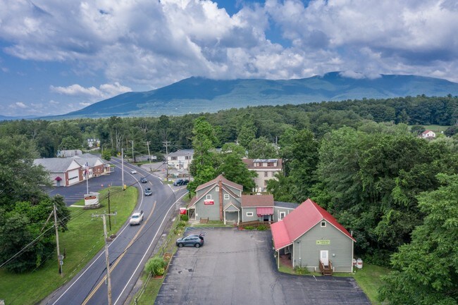
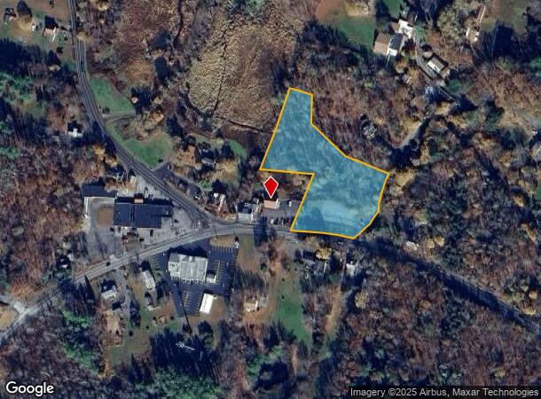
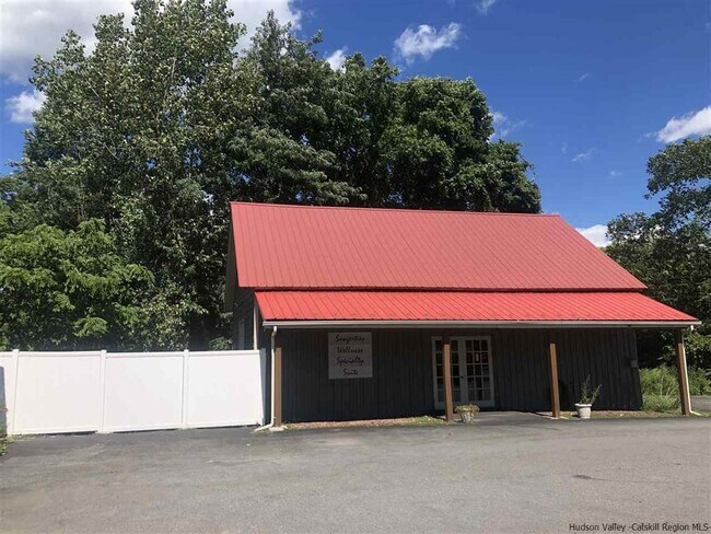
Property Record
844 Route 212, Saugerties, NY 12477
NEARBY LISTINGS FOR SALE OR LEASE
-
-
View all Saugerties listings for sale on LoopNet.com
Property Detail
844 Route 212
Kingston, NY
Map Minor Subdivision Lands Ronald & Gre
4889-017.003-0003-005.001-0000
Ulster
Commercialacreage
New York
X
5.001
36111C0285E
2.30 AC
2025
Hudson Valley Area
2024
Other Market Areas
950100
DEMOGRAPHICS near 844 Route 212
1 Mile
3 Mile
5 Mile
2024 Total Population
548
6,628
19,968
2029 Population
556
6,709
19,992
Pop Growth 2024-2029
+ 1.46%
+ 1.22%
+ 0.12%
Average Age
47
46
45
2024 Total Households
237
2,900
8,726
HH Growth 2024-2029
+ 1.27%
+ 1.21%
+ 0.15%
Median Household Inc
$74,999
$80,429
$76,275
Avg Household Size
2.20
2.20
2.20
2024 Avg HH Vehicles
2.00
2.00
2.00
Median Home Value
$308,871
$324,751
$300,990
Median Year Built
1974
1967
1964
Nearby Places
- Restaurants
- Banks
- Shops
- Fitness
- Groceries
SALE & LEASE HISTORY
LISTING DATE
SALE/LEASE

Oct 09, 2020
For Sale
Aug 09, 2019
For Sale
Nearby Properties
Address
Land Use
TOTAL SIZE
Lot Size
Zoning
Address
Land Use
TOTAL SIZE
Lot Size
Zoning
19.70 AC
04
Address
Land Use
TOTAL SIZE
Lot Size
Zoning
45,441 SF
4.80 AC
05 - COMME
Address
Land Use
TOTAL SIZE
Lot Size
Zoning
77,033 SF
7.40 AC
05 - COMME
Address
Land Use
TOTAL SIZE
Lot Size
Zoning
2,548 SF
8 AC
05 - COMME
Address
Land Use
TOTAL SIZE
Lot Size
Zoning
48,670 SF
10.10 AC
05 - COMME
Address
Land Use
TOTAL SIZE
Lot Size
Zoning
50,036 SF
19 AC
02 - SINGL
Address
Land Use
TOTAL SIZE
Lot Size
Zoning
47,688 SF
5.55 AC
05 - COMME
Address
Land Use
TOTAL SIZE
Lot Size
Zoning
1,944 SF
10.10 AC
9
Address
Land Use
TOTAL SIZE
Lot Size
Zoning
561.60 AC
05 - COMME
Address
Land Use
TOTAL SIZE
Lot Size
Zoning
18.60 AC
R2
Address
Land Use
TOTAL SIZE
Lot Size
Zoning
30,052 SF
4.30 AC
05 - COMME
Address
Land Use
TOTAL SIZE
Lot Size
Zoning
20,040 SF
1.20 AC
07 - MIXED
Address
Land Use
TOTAL SIZE
Lot Size
Zoning
12,088 SF
1.50 AC
05 - COMME
Address
Land Use
TOTAL SIZE
Lot Size
Zoning
23,936 SF
1.50 AC
06 - INDUS
Address
Land Use
TOTAL SIZE
Lot Size
Zoning
52,000 SF
7.73 AC
06 - INDUS
Address
Land Use
TOTAL SIZE
Lot Size
Zoning
7,520 SF
2.30 AC
05 - COMME
Address
Land Use
TOTAL SIZE
Lot Size
Zoning
5,890 SF
37.31 AC
02 - SINGL
Address
Land Use
TOTAL SIZE
Lot Size
Zoning
6,800 SF
0.42 AC
07 - MIXED
Address
Land Use
TOTAL SIZE
Lot Size
Zoning
4,261 SF
2.40 AC
05 - COMME
Address
Land Use
TOTAL SIZE
Lot Size
Zoning
14,628 SF
23.80 AC
02 - SINGL
Address
Land Use
TOTAL SIZE
Lot Size
Zoning
8,960 SF
2 AC
06 - INDUS
Address
Land Use
TOTAL SIZE
Lot Size
Zoning
2,130 SF
35 AC
02 - SINGL
Address
Land Use
TOTAL SIZE
Lot Size
Zoning
8,000 SF
75.60 AC
02 - SINGL
Address
Land Use
TOTAL SIZE
Lot Size
Zoning
2,634 SF
24.20 AC
02 - SINGL
Address
Land Use
TOTAL SIZE
Lot Size
Zoning
5,100 SF
5.10 AC
05 - COMME
Address
Land Use
TOTAL SIZE
Lot Size
Zoning
20,840 SF
4.90 AC
06 - INDUS
Address
Land Use
TOTAL SIZE
Lot Size
Zoning
3,996 SF
61.60 AC
06 - INDUS
Address
Land Use
TOTAL SIZE
Lot Size
Zoning
1,560 SF
19.75 AC
15
Address
Land Use
TOTAL SIZE
Lot Size
Zoning
110,520 SF
10.10 AC
06 - INDUS
Address
Land Use
TOTAL SIZE
Lot Size
Zoning
3,000 SF
4.90 AC
02 - SINGL
The World's #1 Commercial Real Estate Marketplace
Connect with us
© 2025 CoStar Group
The information above has been obtained from sources believed reliable. While we do not doubt its accuracy we have not verified it and make no guarantee, warranty or representation about it. It is your responsibility to independently confirm its accuracy and completeness. Any projections, opinions, assumptions, or estimates used are for example only and do not represent the current or future performance of the property. The value of this transaction to you depends on tax and other factors which should be evaluated by your tax, financial, and legal advisors. You and your advisors should conduct a careful, independent investigation of the property to determine to your satisfaction the suitability of the property for your needs.