Property Record
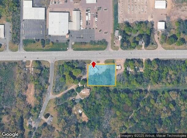
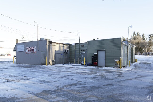
8441 W Main St, Kalamazoo, MI 49009

NEARBY LISTINGS FOR SALE OR LEASE
Property Detail
8441 W Main St
05-16-405-010
SEC 16-2-12 COM AT NW COR SE1/4 TH S ALG N&S1/4 LI SD SEC 48 R TH E 18 R 6 FT TH N 48 R TO E&W1/4 LI SD SEC TH W THERE ON 18
Commercialnec
Kalamazoo
X
Michigan
26077C0175E
1.23 AC
2024
Western Kalamazoo County
2025
West Michigan
002909
Kalamazoo-Portage, MI
2,718 SF
DEMOGRAPHICS near 8441 W Main St
1 Mile
3 Mile
5 Mile
2024 Total Population
673
12,875
55,170
2029 Population
672
12,839
55,134
Pop Growth 2024-2029
(0.15%)
(0.28%)
(0.07%)
Average Age
42
40
37
2024 Total Households
262
5,290
24,332
HH Growth 2024-2029
(0.38%)
(0.42%)
(0.04%)
Median Household Inc
$103,676
$72,596
$53,951
Avg Household Size
2.50
2.40
2.20
2024 Avg HH Vehicles
2.00
2.00
2.00
Median Home Value
$319,512
$270,845
$242,744
Median Year Built
1987
1989
1985
Nearby Places
Map Layers
Map Styles
 Street
 Aerial
- Restaurants
- Banks
- Shops
- Fitness
- Groceries
PUBLIC TRANSPORTATION
AIRPORT
Kalamazoo/Battle Creek International
DRIVE
WALK
Distance
Kalamazoo/Battle Creek International
14 min
12.6 mi
Freight Ports
Port of Baltimore
DRIVE
WALK
Distance
Port of Baltimore
1 min
520.7 mi
Nearby Properties
Address
Land Use
TOTAL SIZE
Lot Size
Zoning
Address
Land Use
TOTAL SIZE
Lot Size
Zoning
125,343 SF
37.39 AC
C-1 COM
Address
Land Use
TOTAL SIZE
Lot Size
Zoning
265,402 SF
21.70 AC
R-4 MUL
Address
Land Use
TOTAL SIZE
Lot Size
Zoning
304,247 SF
44.91 AC
R-4 MUL
Address
Land Use
TOTAL SIZE
Lot Size
Zoning
447,142 SF
34.79 AC
R-4 MUL
Address
Land Use
TOTAL SIZE
Lot Size
Zoning
126.09 AC
R-5 MHP
Address
Land Use
TOTAL SIZE
Lot Size
Zoning
217,443 SF
36.48 AC
C COMM
Address
Land Use
TOTAL SIZE
Lot Size
Zoning
216,972 SF
30.83 AC
C COMM
Address
Land Use
TOTAL SIZE
Lot Size
Zoning
86,306 SF
3.72 AC
C COMM
Address
Land Use
TOTAL SIZE
Lot Size
Zoning
123,653 SF
21.11 AC
C COMM
Address
Land Use
TOTAL SIZE
Lot Size
Zoning
40,534 SF
NOT AP
Address
Land Use
TOTAL SIZE
Lot Size
Zoning
52,908 SF
5.34 AC
R-2 RES
Address
Land Use
TOTAL SIZE
Lot Size
Zoning
51,000 SF
7.70 AC
R-4 MUL
Address
Land Use
TOTAL SIZE
Lot Size
Zoning
58,710 SF
5.14 AC
C COMM
Address
Land Use
TOTAL SIZE
Lot Size
Zoning
65,543 SF
2.08 AC
C COMM
Address
Land Use
TOTAL SIZE
Lot Size
Zoning
33,513 SF
Address
Land Use
TOTAL SIZE
Lot Size
Zoning
182,700 SF
17.67 AC
R-4 MUL
Address
Land Use
TOTAL SIZE
Lot Size
Zoning
27,393 SF
12.37 AC
R-3 RES
Address
Land Use
TOTAL SIZE
Lot Size
Zoning
40,867 SF
Address
Land Use
TOTAL SIZE
Lot Size
Zoning
Address
Land Use
TOTAL SIZE
Lot Size
Zoning
26,007 SF
Address
Land Use
TOTAL SIZE
Lot Size
Zoning
108,595 SF
30.54 AC
C COMM
Address
Land Use
TOTAL SIZE
Lot Size
Zoning
58,874 SF
15.29 AC
C COMM
Address
Land Use
TOTAL SIZE
Lot Size
Zoning
7.70 AC
Address
Land Use
TOTAL SIZE
Lot Size
Zoning
Address
Land Use
TOTAL SIZE
Lot Size
Zoning
12,310 SF
3.64 AC
C COMM
Address
Land Use
TOTAL SIZE
Lot Size
Zoning
20,181 SF
4.67 AC
C COMM
Address
Land Use
TOTAL SIZE
Lot Size
Zoning
3,288 SF
119.52 AC
RR
Address
Land Use
TOTAL SIZE
Lot Size
Zoning
4,545 SF
0.93 AC
C COMM
Address
Land Use
TOTAL SIZE
Lot Size
Zoning
14,623 SF
15.16 AC
R-2 RES
Address
Land Use
TOTAL SIZE
Lot Size
Zoning
4.79 AC
The World's #1 Commercial Real Estate Marketplace
Connect with us
© 2025 CoStar Group
The information above has been obtained from sources believed reliable. While we do not doubt its accuracy we have not verified it and make no guarantee, warranty or representation about it. It is your responsibility to independently confirm its accuracy and completeness. Any projections, opinions, assumptions, or estimates used are for example only and do not represent the current or future performance of the property. The value of this transaction to you depends on tax and other factors which should be evaluated by your tax, financial, and legal advisors. You and your advisors should conduct a careful, independent investigation of the property to determine to your satisfaction the suitability of the property for your needs.