Property Record
8445 Rausch Dr, Plain City, OH 43064


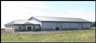

Property Detail
8445 Rausch Dr
Columbus, OH
INDUSTRIAL PARKWAY CORP VMS 7073 ESTATES PH 2LOT 9 202208040007488
15-0027019-0100
Franklin
Publicstorage
Ohio
B and X Area of moderate flood hazard, usually the area between the limits of the 100-year and 500-year floods.
9
2025
1.54 AC
2025
Union County
050601
Columbus
9,750 SF
NEARBY LISTINGS FOR SALE OR LEASE
DEMOGRAPHICS near 8445 Rausch Dr
1 mile
3 mile
5 mile
2025 Total Population
382
23,428
70,602
2030 Population
449
25,709
75,314
Pop Growth 2025-2030
+ 17.54%
+ 9.74%
+ 6.67%
Average Age
36
38
39
2025 Total Households
125
7,577
25,071
HH Growth 2025-2030
+ 17.60%
+ 10.07%
+ 6.58%
Median Household Inc
$175,000
$180,828
$144,420
Avg Household Size
3.10
3.00
2.80
2025 Avg HH Vehicles
2.00
2.00
2.00
Median Home Value
$688,405
$650,936
$543,062
Median Year Built
2011
2004
1999
Nearby Places
Map Layers
Map Styles
 Street
 Aerial
Layers
 Traffic
 Biking
Places
Listings with unknown addresses are not visible on the map
- Restaurants
- Banks
- Shops
- Fitness
- Groceries
PUBLIC TRANSPORTATION
AIRPORT
John Glenn Columbus International
Drive
Walk
Distance
John Glenn Columbus International
38 min
26.8 mi
Rickenbacker International
Drive
Walk
Distance
Rickenbacker International
45 min
32.3 mi
SALE & LEASE HISTORY
LISTING DATE
SALE/LEASE

Sep 25, 2016
For Lease
Sep 23, 2016
For Sale
May 02, 2018
For Lease
Dec 19, 2023
For Lease
Nearby Properties
Address
Land Use
TOTAL SIZE
Lot Size
Zoning
Address
Land Use
TOTAL SIZE
Lot Size
Zoning
464,088 SF
45.57 AC
Address
Land Use
TOTAL SIZE
Lot Size
Zoning
768,498 SF
66.96 AC
Address
Land Use
TOTAL SIZE
Lot Size
Zoning
256,984 SF
10.49 AC
Address
Land Use
TOTAL SIZE
Lot Size
Zoning
86.18 AC
Address
Land Use
TOTAL SIZE
Lot Size
Zoning
7,048 SF
35.41 AC
Address
Land Use
TOTAL SIZE
Lot Size
Zoning
Address
Land Use
TOTAL SIZE
Lot Size
Zoning
4,788 SF
96.85 AC
Address
Land Use
TOTAL SIZE
Lot Size
Zoning
59,144 SF
87.61 AC
Address
Land Use
TOTAL SIZE
Lot Size
Zoning
131,940 SF
34.46 AC
Address
Land Use
TOTAL SIZE
Lot Size
Zoning
133,091 SF
15.01 AC
Address
Land Use
TOTAL SIZE
Lot Size
Zoning
105,694 SF
14.51 AC
Address
Land Use
TOTAL SIZE
Lot Size
Zoning
121,104 SF
Address
Land Use
TOTAL SIZE
Lot Size
Zoning
7,048 SF
35.41 AC
Address
Land Use
TOTAL SIZE
Lot Size
Zoning
55,622 SF
8.98 AC
Address
Land Use
TOTAL SIZE
Lot Size
Zoning
130,839 SF
13.35 AC
Address
Land Use
TOTAL SIZE
Lot Size
Zoning
1,642 SF
92.78 AC
Address
Land Use
TOTAL SIZE
Lot Size
Zoning
50,238 SF
5 AC
Address
Land Use
TOTAL SIZE
Lot Size
Zoning
44,648 SF
38.47 AC
Address
Land Use
TOTAL SIZE
Lot Size
Zoning
103,368 SF
13.48 AC
Address
Land Use
TOTAL SIZE
Lot Size
Zoning
18,325 SF
19.45 AC
Address
Land Use
TOTAL SIZE
Lot Size
Zoning
9,720 SF
13.18 AC
Address
Land Use
TOTAL SIZE
Lot Size
Zoning
486,569 SF
96.85 AC
Address
Land Use
TOTAL SIZE
Lot Size
Zoning
480 SF
52.07 AC
Address
Land Use
TOTAL SIZE
Lot Size
Zoning
16.85 AC
Address
Land Use
TOTAL SIZE
Lot Size
Zoning
139,000 SF
9.34 AC
Address
Land Use
TOTAL SIZE
Lot Size
Zoning
82,029 SF
5.33 AC
Address
Land Use
TOTAL SIZE
Lot Size
Zoning
79,759 SF
18.87 AC
Address
Land Use
TOTAL SIZE
Lot Size
Zoning
150,380 SF
15.97 AC
Address
Land Use
TOTAL SIZE
Lot Size
Zoning
32,132 SF
3.28 AC
Address
Land Use
TOTAL SIZE
Lot Size
Zoning
32,891 SF
11.94 AC
The World's #1 Commercial Real Estate Marketplace
Connect with us
© 2026 CoStar Group
The information above has been obtained from sources believed reliable. While we do not doubt its accuracy we have not verified it and make no guarantee, warranty or representation about it. It is your responsibility to independently confirm its accuracy and completeness. Any projections, opinions, assumptions, or estimates used are for example only and do not represent the current or future performance of the property. The value of this transaction to you depends on tax and other factors which should be evaluated by your tax, financial, and legal advisors. You and your advisors should conduct a careful, independent investigation of the property to determine to your satisfaction the suitability of the property for your needs.