Property Record
8446 Mill Pond Way, Blossvale, NY 13308


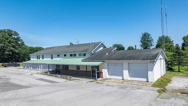
This Property Is For Sale
NEARBY LISTINGS FOR SALE OR LEASE
-
-
View all Blossvale listings for sale on LoopNet.com
Property Detail
8446 Mill Pond Way
183-003-0001-045-000-0000
RENS MARKET
Servicestationmarket
Oneida
X
New York
36065C0314F
45.000
2024
0.70 AC
2024
Outlying Oneida County
026700
Utica/Rome
1,008 SF
Utica-Rome, NY
DEMOGRAPHICS near 8446 Mill Pond Way
1 Mile
3 Mile
5 Mile
2024 Total Population
395
2,168
6,298
2029 Population
391
2,149
6,223
Pop Growth 2024-2029
(1.01%)
(0.88%)
(1.19%)
Average Age
43
43
44
2024 Total Households
150
826
2,566
HH Growth 2024-2029
(0.67%)
(0.97%)
(1.36%)
Median Household Inc
$73,369
$72,338
$62,977
Avg Household Size
2.50
2.50
2.40
2024 Avg HH Vehicles
2.00
2.00
2.00
Median Home Value
$116,667
$120,588
$130,611
Median Year Built
1976
1975
1972
Nearby Places
Map Layers
Map Styles
 Street
 Aerial
- Restaurants
- Banks
- Shops
- Fitness
- Groceries
PUBLIC TRANSPORTATION
AIRPORT
Syracuse Hancock International
DRIVE
WALK
Distance
Syracuse Hancock International
53 min
33.1 mi
Freight Ports
Albany, NY Port
DRIVE
WALK
Distance
Albany, NY Port
156 min
128.1 mi
Nearby Properties
Address
Land Use
TOTAL SIZE
Lot Size
Zoning
Address
Land Use
TOTAL SIZE
Lot Size
Zoning
27,996 SF
12.80 AC
RR1
Address
Land Use
TOTAL SIZE
Lot Size
Zoning
32.40 AC
01 - NOT Z
Address
Land Use
TOTAL SIZE
Lot Size
Zoning
14 AC
01 - NOT Z
Address
Land Use
TOTAL SIZE
Lot Size
Zoning
22.70 AC
01 - NOT Z
Address
Land Use
TOTAL SIZE
Lot Size
Zoning
5,764 SF
25 AC
H
Address
Land Use
TOTAL SIZE
Lot Size
Zoning
3,124 SF
1.50 AC
H
Address
Land Use
TOTAL SIZE
Lot Size
Zoning
2,000 SF
27.10 AC
WR
Address
Land Use
TOTAL SIZE
Lot Size
Zoning
2,312 SF
21.86 AC
RR-1
Address
Land Use
TOTAL SIZE
Lot Size
Zoning
6,750 SF
3.90 AC
C
Address
Land Use
TOTAL SIZE
Lot Size
Zoning
2,716 SF
1.28 AC
H
Address
Land Use
TOTAL SIZE
Lot Size
Zoning
1,120 SF
21 AC
RR1
Address
Land Use
TOTAL SIZE
Lot Size
Zoning
1,800 SF
0.84 AC
RR1
Address
Land Use
TOTAL SIZE
Lot Size
Zoning
1,712 SF
4.52 AC
RR2
Address
Land Use
TOTAL SIZE
Lot Size
Zoning
4,162 SF
21.21 AC
C
Address
Land Use
TOTAL SIZE
Lot Size
Zoning
315.84 AC
RR3
Address
Land Use
TOTAL SIZE
Lot Size
Zoning
45.20 AC
RR1
Address
Land Use
TOTAL SIZE
Lot Size
Zoning
1,650 SF
8 AC
RR1
Address
Land Use
TOTAL SIZE
Lot Size
Zoning
0.17 AC
RR-1
Address
Land Use
TOTAL SIZE
Lot Size
Zoning
4,947 SF
2.45 AC
H
Address
Land Use
TOTAL SIZE
Lot Size
Zoning
282.30 AC
01 - NOT Z
Address
Land Use
TOTAL SIZE
Lot Size
Zoning
183 AC
RR2
Address
Land Use
TOTAL SIZE
Lot Size
Zoning
1 AC
RR1
Address
Land Use
TOTAL SIZE
Lot Size
Zoning
3,962 SF
1.10 AC
H
Address
Land Use
TOTAL SIZE
Lot Size
Zoning
4,688 SF
0.20 AC
H
Address
Land Use
TOTAL SIZE
Lot Size
Zoning
1,528 SF
7 AC
RR2
Address
Land Use
TOTAL SIZE
Lot Size
Zoning
11,800 SF
2.34 AC
C
Address
Land Use
TOTAL SIZE
Lot Size
Zoning
2,770 SF
0.28 AC
H
Address
Land Use
TOTAL SIZE
Lot Size
Zoning
1,960 SF
5.67 AC
RR-1
Address
Land Use
TOTAL SIZE
Lot Size
Zoning
1,820 SF
2.40 AC
RR1
The World's #1 Commercial Real Estate Marketplace
Connect with us
© 2025 CoStar Group
The information above has been obtained from sources believed reliable. While we do not doubt its accuracy we have not verified it and make no guarantee, warranty or representation about it. It is your responsibility to independently confirm its accuracy and completeness. Any projections, opinions, assumptions, or estimates used are for example only and do not represent the current or future performance of the property. The value of this transaction to you depends on tax and other factors which should be evaluated by your tax, financial, and legal advisors. You and your advisors should conduct a careful, independent investigation of the property to determine to your satisfaction the suitability of the property for your needs.