Property Record
845 Johns Hopkins Dr, Greenville, NC 27834
Current Lease Availabilities
NEARBY LISTINGS FOR SALE OR LEASE
Property Detail
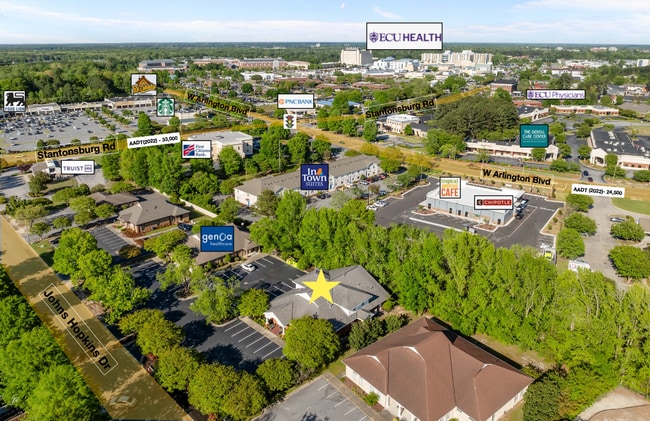
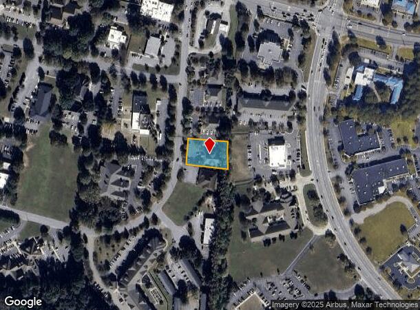
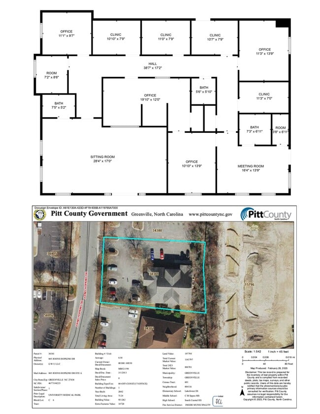
845 Johns Hopkins Dr
Greenville, NC
University Medical Park
034381
UNIVERSITY MEDICAL PARK
Officebuilding
Pitt
X
North Carolina
3720467700K
6
2025
0.54 AC
2025
Southwest Greenville
000604
Other Market Areas
7,124 SF
DEMOGRAPHICS near 845 Johns Hopkins Dr
1 Mile
3 Mile
5 Mile
2024 Total Population
7,550
46,625
104,267
2029 Population
7,933
49,353
109,727
Pop Growth 2024-2029
+ 5.07%
+ 5.85%
+ 5.24%
Average Age
35
34
35
2024 Total Households
3,782
19,936
44,759
HH Growth 2024-2029
+ 5.31%
+ 6.44%
+ 5.73%
Median Household Inc
$41,349
$33,479
$41,575
Avg Household Size
2.00
2.10
2.20
2024 Avg HH Vehicles
2.00
2.00
2.00
Median Home Value
$144,634
$149,592
$175,792
Median Year Built
2002
1993
1993
Nearby Places
Map Layers
Map Styles
 Street
 Aerial
- Restaurants
- Banks
- Shops
- Fitness
- Groceries
PUBLIC TRANSPORTATION
AIRPORT
Pitt-Greenville
DRIVE
WALK
Distance
Pitt-Greenville
13 min
7.7 mi
Freight Ports
Port of Morehead City
DRIVE
WALK
Distance
Port of Morehead City
131 min
86.1 mi
Nearby Properties
Address
Land Use
TOTAL SIZE
Lot Size
Zoning
Address
Land Use
TOTAL SIZE
Lot Size
Zoning
1,674,744 SF
55.66 AC
MI
Address
Land Use
TOTAL SIZE
Lot Size
Zoning
1,555,005 SF
61.20 AC
OR
Address
Land Use
TOTAL SIZE
Lot Size
Zoning
207,166 SF
36.57 AC
OR
Address
Land Use
TOTAL SIZE
Lot Size
Zoning
466,175 SF
14.08 AC
MS
Address
Land Use
TOTAL SIZE
Lot Size
Zoning
780,261 SF
36.60 AC
OR
Address
Land Use
TOTAL SIZE
Lot Size
Zoning
1,002,223 SF
39.45 AC
OR
Address
Land Use
TOTAL SIZE
Lot Size
Zoning
302,575 SF
29.53 AC
MI
Address
Land Use
TOTAL SIZE
Lot Size
Zoning
678,883 SF
41.95 AC
MI
Address
Land Use
TOTAL SIZE
Lot Size
Zoning
473,026 SF
0.69 AC
OR
Address
Land Use
TOTAL SIZE
Lot Size
Zoning
186,634 SF
14.40 AC
MI
Address
Land Use
TOTAL SIZE
Lot Size
Zoning
682,180 SF
4.57 AC
CDF-UC
Address
Land Use
TOTAL SIZE
Lot Size
Zoning
184,433 SF
71.40 AC
MI
Address
Land Use
TOTAL SIZE
Lot Size
Zoning
146,413 SF
12.18 AC
MO
Address
Land Use
TOTAL SIZE
Lot Size
Zoning
512,349 SF
39.27 AC
CG
Address
Land Use
TOTAL SIZE
Lot Size
Zoning
282,000 SF
0.94 AC
OR
Address
Land Use
TOTAL SIZE
Lot Size
Zoning
180,500 SF
2.17 AC
CD
Address
Land Use
TOTAL SIZE
Lot Size
Zoning
29,832 SF
24.89 AC
MR
Address
Land Use
TOTAL SIZE
Lot Size
Zoning
24,993 SF
15.81 AC
OR
Address
Land Use
TOTAL SIZE
Lot Size
Zoning
130,632 SF
5.06 AC
MI
Address
Land Use
TOTAL SIZE
Lot Size
Zoning
348,438 SF
3.89 AC
CD
Address
Land Use
TOTAL SIZE
Lot Size
Zoning
232,380 SF
666.85 AC
IU
Address
Land Use
TOTAL SIZE
Lot Size
Zoning
328,680 SF
2.04 AC
CD
Address
Land Use
TOTAL SIZE
Lot Size
Zoning
356,216 SF
4.08 AC
CDF-UC
Address
Land Use
TOTAL SIZE
Lot Size
Zoning
204,828 SF
10 AC
MS
Address
Land Use
TOTAL SIZE
Lot Size
Zoning
138,115 SF
13.60 AC
OR
Address
Land Use
TOTAL SIZE
Lot Size
Zoning
109,461 SF
1.89 AC
CD
Address
Land Use
TOTAL SIZE
Lot Size
Zoning
142,831 SF
13.61 AC
MO
Address
Land Use
TOTAL SIZE
Lot Size
Zoning
25,290 SF
18.26 AC
OR
Address
Land Use
TOTAL SIZE
Lot Size
Zoning
18,932 SF
11.51 AC
MR
Address
Land Use
TOTAL SIZE
Lot Size
Zoning
8,733 SF
14.26 AC
MR
The World's #1 Commercial Real Estate Marketplace
Connect with us
© 2025 CoStar Group
The information above has been obtained from sources believed reliable. While we do not doubt its accuracy we have not verified it and make no guarantee, warranty or representation about it. It is your responsibility to independently confirm its accuracy and completeness. Any projections, opinions, assumptions, or estimates used are for example only and do not represent the current or future performance of the property. The value of this transaction to you depends on tax and other factors which should be evaluated by your tax, financial, and legal advisors. You and your advisors should conduct a careful, independent investigation of the property to determine to your satisfaction the suitability of the property for your needs.