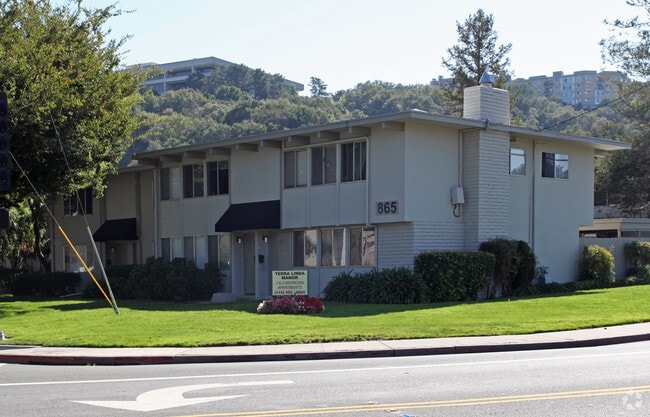
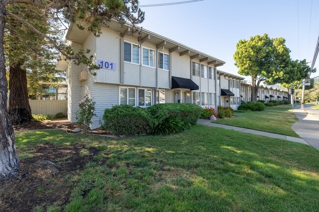
Property Record
845 Las Gallinas Ave, San Rafael, CA 94903

NEARBY LISTINGS FOR SALE OR LEASE
Property Detail
845 Las Gallinas Ave
175-021-16
Northgate Garden Apts
Taxexempt
/B3P16 OR NORTHGATE GARDEN
X
Marin
06041C0293E
California
2025
1.18 AC
2025
Terra Linda
108202
North Bay/Santa Rosa
24,929 SF
San Rafael, CA
DEMOGRAPHICS near 845 Las Gallinas Ave
1 Mile
3 Mile
5 Mile
2024 Total Population
11,473
72,815
133,076
2029 Population
11,159
70,767
129,311
Pop Growth 2024-2029
(2.74%)
(2.81%)
(2.83%)
Average Age
47
45
45
2024 Total Households
4,744
29,782
52,572
HH Growth 2024-2029
(2.68%)
(2.85%)
(2.85%)
Median Household Inc
$102,849
$112,727
$112,728
Avg Household Size
2.30
2.40
2.40
2024 Avg HH Vehicles
2.00
2.00
2.00
Median Home Value
$1,018,682
$1,063,050
$1,069,705
Median Year Built
1967
1962
1965
Nearby Places
Map Layers
Map Styles
 Street
 Aerial
- Restaurants
- Banks
- Shops
- Fitness
- Groceries
PUBLIC TRANSPORTATION
COMMUTER RAIL
Marin Civic Center Smart (Main Line - Sonoma Marin Area Rail Transit)
DRIVE
WALK
Distance
Marin Civic Center Smart (Main Line - Sonoma Marin Area Rail Transit)
1 min
16 min
0.9 mi
San Rafael Smart (Main Line - Sonoma Marin Area Rail Transit)
DRIVE
WALK
Distance
San Rafael Smart (Main Line - Sonoma Marin Area Rail Transit)
5 min
3.2 mi
AIRPORT
San Francisco International
DRIVE
WALK
Distance
San Francisco International
53 min
33.9 mi
Metro Oakland International
DRIVE
WALK
Distance
Metro Oakland International
46 min
34.0 mi
Freight Ports
Port of Richmond
DRIVE
WALK
Distance
Port of Richmond
23 min
14.7 mi
Nearby Properties
Address
Land Use
TOTAL SIZE
Lot Size
Zoning
Address
Land Use
TOTAL SIZE
Lot Size
Zoning
283,663 SF
27.98 AC
Address
Land Use
TOTAL SIZE
Lot Size
Zoning
23.79 AC
Address
Land Use
TOTAL SIZE
Lot Size
Zoning
87,058 SF
1.33 AC
Address
Land Use
TOTAL SIZE
Lot Size
Zoning
221,660 SF
9.69 AC
PC
Address
Land Use
TOTAL SIZE
Lot Size
Zoning
16.43 AC
Address
Land Use
TOTAL SIZE
Lot Size
Zoning
146,832 SF
5.50 AC
Address
Land Use
TOTAL SIZE
Lot Size
Zoning
167,392 SF
12.79 AC
Address
Land Use
TOTAL SIZE
Lot Size
Zoning
147,502 SF
1.02 AC
Address
Land Use
TOTAL SIZE
Lot Size
Zoning
132,040 SF
11.74 AC
Address
Land Use
TOTAL SIZE
Lot Size
Zoning
11.63 AC
Address
Land Use
TOTAL SIZE
Lot Size
Zoning
91,158 SF
1.89 AC
Address
Land Use
TOTAL SIZE
Lot Size
Zoning
15.91 AC
SPD
Address
Land Use
TOTAL SIZE
Lot Size
Zoning
94,745 SF
1.46 AC
Address
Land Use
TOTAL SIZE
Lot Size
Zoning
75,888 SF
10.99 AC
Address
Land Use
TOTAL SIZE
Lot Size
Zoning
195,460 SF
6.10 AC
Address
Land Use
TOTAL SIZE
Lot Size
Zoning
71,527 SF
1.86 AC
Address
Land Use
TOTAL SIZE
Lot Size
Zoning
Address
Land Use
TOTAL SIZE
Lot Size
Zoning
84,245 SF
2.62 AC
Address
Land Use
TOTAL SIZE
Lot Size
Zoning
177,460 SF
13 AC
Address
Land Use
TOTAL SIZE
Lot Size
Zoning
11,830 SF
0.65 AC
Address
Land Use
TOTAL SIZE
Lot Size
Zoning
85,066 SF
1.29 AC
Address
Land Use
TOTAL SIZE
Lot Size
Zoning
48,603 SF
2.54 AC
Address
Land Use
TOTAL SIZE
Lot Size
Zoning
192,037 SF
511.90 AC
Address
Land Use
TOTAL SIZE
Lot Size
Zoning
87,840 SF
1.19 AC
Address
Land Use
TOTAL SIZE
Lot Size
Zoning
139,073 SF
8.98 AC
Address
Land Use
TOTAL SIZE
Lot Size
Zoning
33,641 SF
1.60 AC
Address
Land Use
TOTAL SIZE
Lot Size
Zoning
45,142 SF
2.32 AC
Address
Land Use
TOTAL SIZE
Lot Size
Zoning
6.39 AC
Address
Land Use
TOTAL SIZE
Lot Size
Zoning
142,341 SF
5.83 AC
Address
Land Use
TOTAL SIZE
Lot Size
Zoning
66,700 SF
0.99 AC
The World's #1 Commercial Real Estate Marketplace
Connect with us
© 2025 CoStar Group
The information above has been obtained from sources believed reliable. While we do not doubt its accuracy we have not verified it and make no guarantee, warranty or representation about it. It is your responsibility to independently confirm its accuracy and completeness. Any projections, opinions, assumptions, or estimates used are for example only and do not represent the current or future performance of the property. The value of this transaction to you depends on tax and other factors which should be evaluated by your tax, financial, and legal advisors. You and your advisors should conduct a careful, independent investigation of the property to determine to your satisfaction the suitability of the property for your needs.