Property Record
845 Ridge Rd, Mount Airy, MD 21771


NEARBY LISTINGS FOR SALE OR LEASE
-
-
View all Mount Airy listings for sale on LoopNet.com
Property Detail
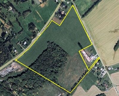
845 Ridge Rd
04-315278
33.38 ACRES 845 RIDGE RD MT AIRY
Agriculturalland
Howard
X
Maryland
24013C0356D
33.38 AC
2024
Outlying Howard County
2025
Baltimore
604001
Baltimore-Columbia-Towson, MD
DEMOGRAPHICS near 845 Ridge Rd
1 mile
3 mile
5 mile
2024 Total Population
1,075
17,270
35,078
2029 Population
1,179
18,663
37,510
Pop Growth 2024-2029
+ 9.67%
+ 8.07%
+ 6.93%
Average Age
41
41
41
2024 Total Households
360
6,042
12,131
HH Growth 2024-2029
+ 10.00%
+ 8.19%
+ 7.11%
Median Household Inc
$147,045
$131,882
$137,615
Avg Household Size
2.90
2.80
2.80
2024 Avg HH Vehicles
3.00
3.00
3.00
Median Home Value
$495,160
$451,850
$485,166
Median Year Built
1996
1989
1985
Nearby Places
Map Layers
Map Styles
 Street
 Aerial
Transit
 Traffic
 Biking
Places
Listings with unknown addresses are not visible on the map
- Restaurants
- Banks
- Shops
- Fitness
- Groceries
PUBLIC TRANSPORTATION
AIRPORT
Baltimore/Washington International Thurgood Marshall
Drive
Walk
Distance
Baltimore/Washington International Thurgood Marshall
45 min
35.3 mi
Freight Ports
Port of Baltimore
Drive
Walk
Distance
Port of Baltimore
46 min
35.8 mi
Nearby Properties
Address
Land Use
TOTAL SIZE
Lot Size
Zoning
Address
Land Use
TOTAL SIZE
Lot Size
Zoning
51,451 SF
46.50 AC
R2
Address
Land Use
TOTAL SIZE
Lot Size
Zoning
11,120 SF
13.49 AC
CC
Address
Land Use
TOTAL SIZE
Lot Size
Zoning
48,427 SF
15.66 AC
CC
Address
Land Use
TOTAL SIZE
Lot Size
Zoning
70,452 SF
14.04 AC
RE
Address
Land Use
TOTAL SIZE
Lot Size
Zoning
6,280 SF
7.96 AC
CC
Address
Land Use
TOTAL SIZE
Lot Size
Zoning
92,230 SF
12.58 AC
CC
Address
Land Use
TOTAL SIZE
Lot Size
Zoning
88,906 SF
5.63 AC
R5
Address
Land Use
TOTAL SIZE
Lot Size
Zoning
44,600 SF
2.28 AC
CC
Address
Land Use
TOTAL SIZE
Lot Size
Zoning
25,600 SF
36 AC
A
Address
Land Use
TOTAL SIZE
Lot Size
Zoning
13,075 SF
37.13 AC
CONSE
Address
Land Use
TOTAL SIZE
Lot Size
Zoning
102,196 SF
13.87 AC
CC
Address
Land Use
TOTAL SIZE
Lot Size
Zoning
6,936 SF
5.18 AC
R7
Address
Land Use
TOTAL SIZE
Lot Size
Zoning
23,275 SF
7 AC
INDUS
Address
Land Use
TOTAL SIZE
Lot Size
Zoning
45,000 SF
12.96 AC
AR
Address
Land Use
TOTAL SIZE
Lot Size
Zoning
4,200 SF
5 AC
INDUS
Address
Land Use
TOTAL SIZE
Lot Size
Zoning
4,440 SF
1.05 AC
CC
Address
Land Use
TOTAL SIZE
Lot Size
Zoning
34.42 AC
CONSE
Address
Land Use
TOTAL SIZE
Lot Size
Zoning
27,013 SF
3.90 AC
RE
Address
Land Use
TOTAL SIZE
Lot Size
Zoning
57,399 SF
2.57 AC
CC
Address
Land Use
TOTAL SIZE
Lot Size
Zoning
17,468 SF
4.69 AC
INDUS
Address
Land Use
TOTAL SIZE
Lot Size
Zoning
7,954 SF
130.90 AC
AR
Address
Land Use
TOTAL SIZE
Lot Size
Zoning
49,140 SF
3.32 AC
I
Address
Land Use
TOTAL SIZE
Lot Size
Zoning
16,209 SF
3.14 AC
R7
Address
Land Use
TOTAL SIZE
Lot Size
Zoning
26,445 SF
2.22 AC
INDUS
Address
Land Use
TOTAL SIZE
Lot Size
Zoning
29,813 SF
0.48 AC
DTZ
Address
Land Use
TOTAL SIZE
Lot Size
Zoning
34,402 SF
2.96 AC
CC
Address
Land Use
TOTAL SIZE
Lot Size
Zoning
11,480 SF
1.20 AC
CC
Address
Land Use
TOTAL SIZE
Lot Size
Zoning
38,941 SF
3.22 AC
DTZ
Address
Land Use
TOTAL SIZE
Lot Size
Zoning
9,200 SF
1.30 AC
RE
Address
Land Use
TOTAL SIZE
Lot Size
Zoning
32,862 SF
3.01 AC
AR
The World's #1 Commercial Real Estate Marketplace
Connect with us
© 2026 CoStar Group
The information above has been obtained from sources believed reliable. While we do not doubt its accuracy we have not verified it and make no guarantee, warranty or representation about it. It is your responsibility to independently confirm its accuracy and completeness. Any projections, opinions, assumptions, or estimates used are for example only and do not represent the current or future performance of the property. The value of this transaction to you depends on tax and other factors which should be evaluated by your tax, financial, and legal advisors. You and your advisors should conduct a careful, independent investigation of the property to determine to your satisfaction the suitability of the property for your needs.