Property Record
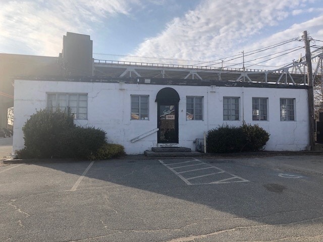
1 Belmont Rd, West Harwich, MA 02671

Current Lease Availabilities
NEARBY LISTINGS FOR SALE OR LEASE
Property Detail
1 Belmont Rd
HARW-000001-000000-C000001-000634
Barnstable
Condominium
Massachusetts
AE
Cape Cod
25001C0611J
Other Market Areas
1,832 SF
Barnstable Town, MA
DEMOGRAPHICS near 1 Belmont Rd
1 Mile
3 Mile
5 Mile
2024 Total Population
1,910
10,629
30,204
2029 Population
1,781
10,433
30,280
Pop Growth 2024-2029
(6.75%)
(1.84%)
+ 0.25%
Average Age
44
47
45
2024 Total Households
764
4,382
11,861
HH Growth 2024-2029
(7.72%)
(2.35%)
(0.15%)
Median Household Inc
$98,025
$99,279
$94,335
Avg Household Size
2.40
2.30
2.40
2024 Avg HH Vehicles
2.00
2.00
2.00
Median Home Value
$447,407
$454,814
$449,113
Median Year Built
1981
1980
1980
Nearby Places
Map Layers
Map Styles
 Street
 Aerial
- Restaurants
- Banks
- Shops
- Fitness
- Groceries
PUBLIC TRANSPORTATION
COMMUTER RAIL
Hyannis (CapeFLYER - Cape Cod Regional Transit Authority)
DRIVE
WALK
Distance
Hyannis (CapeFLYER - Cape Cod Regional Transit Authority)
18 min
9.8 mi
AIRPORT
Nantucket Memorial
DRIVE
WALK
Distance
Nantucket Memorial
168 min
43.2 mi
Freight Ports
Port of New Bedford Harbor
DRIVE
WALK
Distance
Port of New Bedford Harbor
83 min
58.5 mi
Nearby Properties
Address
Land Use
TOTAL SIZE
Lot Size
Zoning
Address
Land Use
TOTAL SIZE
Lot Size
Zoning
13.34 AC
E
Address
Land Use
TOTAL SIZE
Lot Size
Zoning
2,117 SF
Address
Land Use
TOTAL SIZE
Lot Size
Zoning
Address
Land Use
TOTAL SIZE
Lot Size
Zoning
3.42 AC
Address
Land Use
TOTAL SIZE
Lot Size
Zoning
10.34 AC
Address
Land Use
TOTAL SIZE
Lot Size
Zoning
Address
Land Use
TOTAL SIZE
Lot Size
Zoning
3.58 AC
R
Address
Land Use
TOTAL SIZE
Lot Size
Zoning
3,480 SF
22.78 AC
E
Address
Land Use
TOTAL SIZE
Lot Size
Zoning
Address
Land Use
TOTAL SIZE
Lot Size
Zoning
14,844 SF
0.50 AC
Address
Land Use
TOTAL SIZE
Lot Size
Zoning
Address
Land Use
TOTAL SIZE
Lot Size
Zoning
Address
Land Use
TOTAL SIZE
Lot Size
Zoning
4.88 AC
E
Address
Land Use
TOTAL SIZE
Lot Size
Zoning
59,054 SF
9.53 AC
R
Address
Land Use
TOTAL SIZE
Lot Size
Zoning
1.52 AC
R
Address
Land Use
TOTAL SIZE
Lot Size
Zoning
2,003 SF
1.57 AC
R
Address
Land Use
TOTAL SIZE
Lot Size
Zoning
0.78 AC
R
Address
Land Use
TOTAL SIZE
Lot Size
Zoning
1.32 AC
R
Address
Land Use
TOTAL SIZE
Lot Size
Zoning
Address
Land Use
TOTAL SIZE
Lot Size
Zoning
6,276 SF
0.80 AC
R
Address
Land Use
TOTAL SIZE
Lot Size
Zoning
Address
Land Use
TOTAL SIZE
Lot Size
Zoning
0.80 AC
R
Address
Land Use
TOTAL SIZE
Lot Size
Zoning
9.77 AC
Address
Land Use
TOTAL SIZE
Lot Size
Zoning
45.75 AC
R
Address
Land Use
TOTAL SIZE
Lot Size
Zoning
0.41 AC
R
Address
Land Use
TOTAL SIZE
Lot Size
Zoning
1.55 AC
R
Address
Land Use
TOTAL SIZE
Lot Size
Zoning
26,948 SF
Address
Land Use
TOTAL SIZE
Lot Size
Zoning
1.03 AC
R
Address
Land Use
TOTAL SIZE
Lot Size
Zoning
4,744 SF
0.44 AC
R
Address
Land Use
TOTAL SIZE
Lot Size
Zoning
62,423 SF
13.98 AC
The World's #1 Commercial Real Estate Marketplace
Connect with us
© 2026 CoStar Group
The information above has been obtained from sources believed reliable. While we do not doubt its accuracy we have not verified it and make no guarantee, warranty or representation about it. It is your responsibility to independently confirm its accuracy and completeness. Any projections, opinions, assumptions, or estimates used are for example only and do not represent the current or future performance of the property. The value of this transaction to you depends on tax and other factors which should be evaluated by your tax, financial, and legal advisors. You and your advisors should conduct a careful, independent investigation of the property to determine to your satisfaction the suitability of the property for your needs.