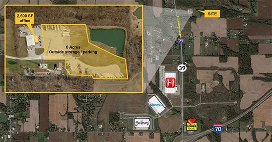
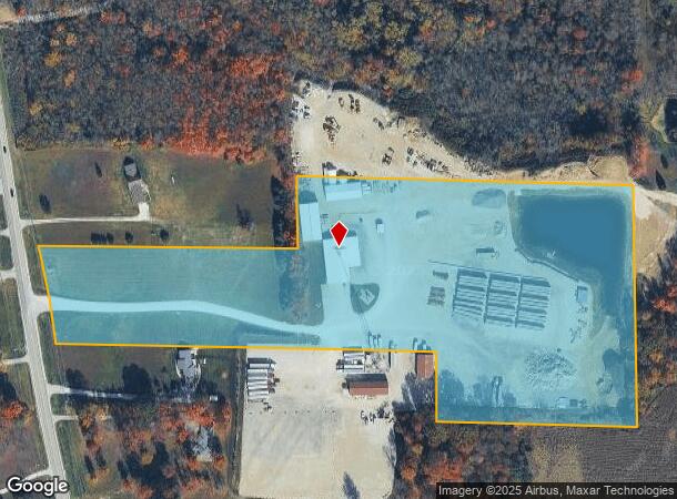
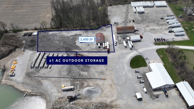
Property Record
8451 S State Road 39, Clayton, IN 46118
Current Lease Availabilities
NEARBY LISTINGS FOR SALE OR LEASE
Property Detail
8451 S State Road 39
32-14-24-100-027.000-013
PT NW1/4 24-14-1W 16.49AC
Commercialnec
Hendricks
X
Indiana
18109C0015E
16.49 AC
2024
West Hendricks Cty
2024
Indianapolis
211000
Indianapolis-Carmel-Greenwood, IN
9,840 SF
DEMOGRAPHICS near 8451 S State Road 39
1 Mile
3 Mile
5 Mile
2024 Total Population
582
3,569
19,905
2029 Population
646
3,890
21,716
Pop Growth 2024-2029
+ 11.00%
+ 8.99%
+ 9.10%
Average Age
44
43
41
2024 Total Households
227
1,368
6,808
HH Growth 2024-2029
+ 11.01%
+ 9.06%
+ 8.96%
Median Household Inc
$80,048
$82,723
$90,371
Avg Household Size
2.50
2.60
2.60
2024 Avg HH Vehicles
3.00
2.00
2.00
Median Home Value
$257,638
$260,088
$254,469
Median Year Built
1973
1976
1999
Nearby Places
Map Layers
Map Styles
 Street
 Aerial
- Restaurants
- Banks
- Shops
- Fitness
- Groceries
PUBLIC TRANSPORTATION
AIRPORT
Indianapolis International
DRIVE
WALK
Distance
Indianapolis International
22 min
14.5 mi
Freight Ports
Port of Toledo
DRIVE
WALK
Distance
Port of Toledo
300 min
249.4 mi
Nearby Properties
Address
Land Use
TOTAL SIZE
Lot Size
Zoning
Address
Land Use
TOTAL SIZE
Lot Size
Zoning
1,049,878 SF
113.60 AC
Address
Land Use
TOTAL SIZE
Lot Size
Zoning
76.76 AC
Address
Land Use
TOTAL SIZE
Lot Size
Zoning
69.65 AC
Address
Land Use
TOTAL SIZE
Lot Size
Zoning
60.85 AC
Address
Land Use
TOTAL SIZE
Lot Size
Zoning
43.38 AC
Address
Land Use
TOTAL SIZE
Lot Size
Zoning
52.40 AC
Address
Land Use
TOTAL SIZE
Lot Size
Zoning
577,046 SF
59.48 AC
Address
Land Use
TOTAL SIZE
Lot Size
Zoning
56.08 AC
Address
Land Use
TOTAL SIZE
Lot Size
Zoning
601,744 SF
44.09 AC
Address
Land Use
TOTAL SIZE
Lot Size
Zoning
Address
Land Use
TOTAL SIZE
Lot Size
Zoning
597,500 SF
44.22 AC
Address
Land Use
TOTAL SIZE
Lot Size
Zoning
34.54 AC
Address
Land Use
TOTAL SIZE
Lot Size
Zoning
26.24 AC
Address
Land Use
TOTAL SIZE
Lot Size
Zoning
37.89 AC
Address
Land Use
TOTAL SIZE
Lot Size
Zoning
67.08 AC
Address
Land Use
TOTAL SIZE
Lot Size
Zoning
20.47 AC
Address
Land Use
TOTAL SIZE
Lot Size
Zoning
12,152 SF
10.66 AC
Address
Land Use
TOTAL SIZE
Lot Size
Zoning
190.58 AC
Address
Land Use
TOTAL SIZE
Lot Size
Zoning
17,389 SF
13.79 AC
Address
Land Use
TOTAL SIZE
Lot Size
Zoning
8,000 SF
3.51 AC
Address
Land Use
TOTAL SIZE
Lot Size
Zoning
71,402 SF
7.07 AC
Address
Land Use
TOTAL SIZE
Lot Size
Zoning
2,392 SF
20.36 AC
Address
Land Use
TOTAL SIZE
Lot Size
Zoning
10,265 SF
116.12 AC
Address
Land Use
TOTAL SIZE
Lot Size
Zoning
4,080 SF
1.71 AC
Address
Land Use
TOTAL SIZE
Lot Size
Zoning
7,656 SF
0.79 AC
Address
Land Use
TOTAL SIZE
Lot Size
Zoning
7,000 SF
3.83 AC
Address
Land Use
TOTAL SIZE
Lot Size
Zoning
3,600 SF
1.88 AC
Address
Land Use
TOTAL SIZE
Lot Size
Zoning
9,000 SF
0.86 AC
Address
Land Use
TOTAL SIZE
Lot Size
Zoning
7,656 SF
0.84 AC
The World's #1 Commercial Real Estate Marketplace
Connect with us
© 2026 CoStar Group
The information above has been obtained from sources believed reliable. While we do not doubt its accuracy we have not verified it and make no guarantee, warranty or representation about it. It is your responsibility to independently confirm its accuracy and completeness. Any projections, opinions, assumptions, or estimates used are for example only and do not represent the current or future performance of the property. The value of this transaction to you depends on tax and other factors which should be evaluated by your tax, financial, and legal advisors. You and your advisors should conduct a careful, independent investigation of the property to determine to your satisfaction the suitability of the property for your needs.