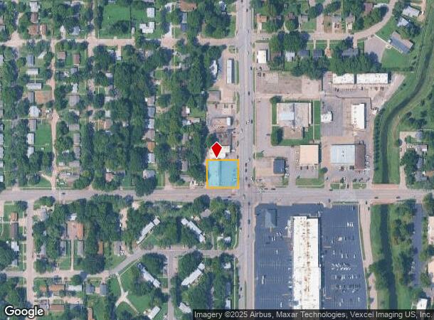
Property Record
847-859 S Oliver Ave, Wichita, KS 67218
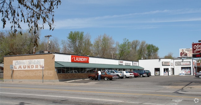
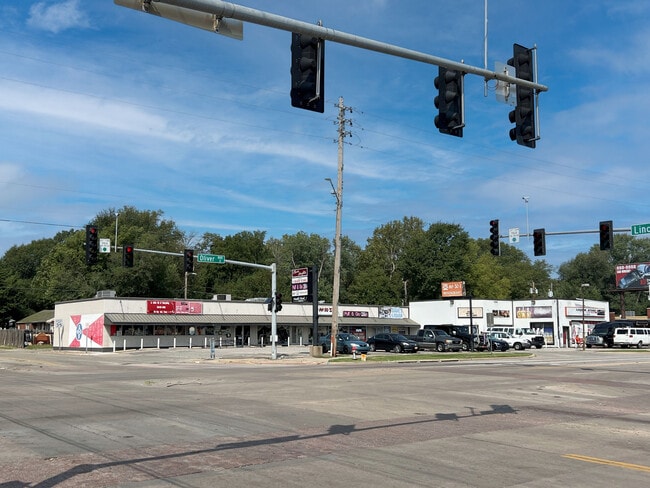
This Property Is For Sale
NEARBY LISTINGS FOR SALE OR LEASE
Property Detail
847-859 S Oliver Ave
Wichita, KS
Oliver Heights Add
127-26-0-14-08-009.00B
LOTS 11-12 & S 1.83 FT LOT 13 OLIVER HEIGHTS ADD.
Storebuilding
Sedgwick
X
Kansas
20173C0367G
13
2024
0.37 AC
2025
Southeast
003600
Wichita
4,800 SF
DEMOGRAPHICS near 847-859 S Oliver Ave
1 Mile
3 Mile
5 Mile
2024 Total Population
16,629
104,897
220,547
2029 Population
17,163
107,946
226,860
Pop Growth 2024-2029
+ 3.21%
+ 2.91%
+ 2.86%
Average Age
38
37
37
2024 Total Households
7,133
43,875
89,954
HH Growth 2024-2029
+ 3.18%
+ 2.83%
+ 2.84%
Median Household Inc
$39,009
$47,284
$47,294
Avg Household Size
2.20
2.30
2.30
2024 Avg HH Vehicles
2.00
2.00
2.00
Median Home Value
$90,785
$120,322
$124,350
Median Year Built
1954
1957
1963
Nearby Places
- Restaurants
- Banks
- Shops
- Fitness
- Groceries
PUBLIC TRANSPORTATION
AIRPORT
Wichita Dwight D Eisenhower Ntl
DRIVE
WALK
Distance
Wichita Dwight D Eisenhower Ntl
16 min
10.1 mi
Freight Ports
Tulsa Port Of Catoosa
DRIVE
WALK
Distance
Tulsa Port Of Catoosa
206 min
192.6 mi
Nearby Properties
Address
Land Use
TOTAL SIZE
Lot Size
Zoning
Address
Land Use
TOTAL SIZE
Lot Size
Zoning
468,755 SF
10.41 AC
CBD,LI
Address
Land Use
TOTAL SIZE
Lot Size
Zoning
430,593 SF
11.89 AC
GO,LC
Address
Land Use
TOTAL SIZE
Lot Size
Zoning
576,707 SF
53.70 AC
B,LC
Address
Land Use
TOTAL SIZE
Lot Size
Zoning
271,541 SF
39.20 AC
GO
Address
Land Use
TOTAL SIZE
Lot Size
Zoning
237,087 SF
48.33 AC
B
Address
Land Use
TOTAL SIZE
Lot Size
Zoning
418.47 AC
AFB
Address
Land Use
TOTAL SIZE
Lot Size
Zoning
197,464 SF
4.05 AC
CBD
Address
Land Use
TOTAL SIZE
Lot Size
Zoning
527,510 SF
50.27 AC
TF-3
Address
Land Use
TOTAL SIZE
Lot Size
Zoning
204,778 SF
24.53 AC
SF-5
Address
Land Use
TOTAL SIZE
Lot Size
Zoning
167,304 SF
6.19 AC
MF-29
Address
Land Use
TOTAL SIZE
Lot Size
Zoning
152,978 SF
7.86 AC
LI
Address
Land Use
TOTAL SIZE
Lot Size
Zoning
945,203 SF
9.53 AC
GO
Address
Land Use
TOTAL SIZE
Lot Size
Zoning
108,232 SF
3.72 AC
PUD
Address
Land Use
TOTAL SIZE
Lot Size
Zoning
167,315 SF
2 AC
LC,SF-5
Address
Land Use
TOTAL SIZE
Lot Size
Zoning
728,346 SF
33.17 AC
LC
Address
Land Use
TOTAL SIZE
Lot Size
Zoning
84,788 SF
5.98 AC
PUD
Address
Land Use
TOTAL SIZE
Lot Size
Zoning
65,973 SF
5.39 AC
TF-3
Address
Land Use
TOTAL SIZE
Lot Size
Zoning
81,870 SF
3.70 AC
B,GC
Address
Land Use
TOTAL SIZE
Lot Size
Zoning
106,159 SF
16.16 AC
SF-5
Address
Land Use
TOTAL SIZE
Lot Size
Zoning
69,383 SF
9.53 AC
GO
Address
Land Use
TOTAL SIZE
Lot Size
Zoning
112,088 SF
4.05 AC
SF-5,B
Address
Land Use
TOTAL SIZE
Lot Size
Zoning
71,568 SF
4.83 AC
TF-3
Address
Land Use
TOTAL SIZE
Lot Size
Zoning
154,691 SF
8.40 AC
SF-5
Address
Land Use
TOTAL SIZE
Lot Size
Zoning
56,642 SF
114.61 AC
SF-5
Address
Land Use
TOTAL SIZE
Lot Size
Zoning
59,837 SF
3.72 AC
TF-3
Address
Land Use
TOTAL SIZE
Lot Size
Zoning
54,975 SF
13.80 AC
GC
Address
Land Use
TOTAL SIZE
Lot Size
Zoning
98,077 SF
10.92 AC
SF-5
Address
Land Use
TOTAL SIZE
Lot Size
Zoning
75,620 SF
10.42 AC
SF-5
Address
Land Use
TOTAL SIZE
Lot Size
Zoning
119,245 SF
10.77 AC
MF29
The World's #1 Commercial Real Estate Marketplace
Connect with us
© 2025 CoStar Group
The information above has been obtained from sources believed reliable. While we do not doubt its accuracy we have not verified it and make no guarantee, warranty or representation about it. It is your responsibility to independently confirm its accuracy and completeness. Any projections, opinions, assumptions, or estimates used are for example only and do not represent the current or future performance of the property. The value of this transaction to you depends on tax and other factors which should be evaluated by your tax, financial, and legal advisors. You and your advisors should conduct a careful, independent investigation of the property to determine to your satisfaction the suitability of the property for your needs.