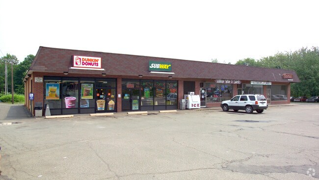
Property Record
847 Forest Rd, Northford, CT 06472

Property Detail
847 Forest Rd
NBRA-000062A-000000-000038
South Central Ct
Commercialnec
Connecticut
B2
2.26 AC
AE The base floodplain where base flood elevations are provided. AE Zones are now used on new format FIRMs instead of A1-A30 Zones.
Branford
2025
Westchester/So Connecticut
2025
New Haven, CT
186200
NEARBY LISTINGS FOR SALE OR LEASE
-
-
View all Northford listings for sale on LoopNet.com
DEMOGRAPHICS near 847 Forest Rd
1 mile
3 mile
5 mile
2025 Total Population
2,071
16,001
58,883
2030 Population
2,086
16,297
59,618
Pop Growth 2025-2030
+ 0.72%
+ 1.85%
+ 1.25%
Average Age
45
45
44
2025 Total Households
775
6,202
23,356
HH Growth 2025-2030
+ 0.52%
+ 1.81%
+ 1.16%
Median Household Inc
$106,828
$98,724
$103,801
Avg Household Size
2.60
2.50
2.50
2025 Avg HH Vehicles
2.00
2.00
2.00
Median Home Value
$406,211
$390,586
$374,159
Median Year Built
1971
1973
1969
Nearby Places
Map Layers
Map Styles
 Street
 Aerial
Layers
 Traffic
 Biking
Places
Listings with unknown addresses are not visible on the map
- Restaurants
- Banks
- Shops
- Fitness
- Groceries
PUBLIC TRANSPORTATION
COMMUTER RAIL
Drive
Walk
Distance
11 min
5.8 mi
Drive
Walk
Distance
12 min
6.1 mi
AIRPORT
Tweed/New Haven
Drive
Walk
Distance
Tweed/New Haven
23 min
11.8 mi
Nearby Properties
Address
Land Use
TOTAL SIZE
Lot Size
Zoning
Address
Land Use
TOTAL SIZE
Lot Size
Zoning
100 AC
LO15
Address
Land Use
TOTAL SIZE
Lot Size
Zoning
97,898 SF
11.40 AC
R20
Address
Land Use
TOTAL SIZE
Lot Size
Zoning
15,432 SF
5.67 AC
CB40
Address
Land Use
TOTAL SIZE
Lot Size
Zoning
20.01 AC
R20
Address
Land Use
TOTAL SIZE
Lot Size
Zoning
91,455 SF
14.20 AC
RU-2
Address
Land Use
TOTAL SIZE
Lot Size
Zoning
64,827 SF
24.94 AC
R40
Address
Land Use
TOTAL SIZE
Lot Size
Zoning
60,678 SF
21.50 AC
R40
Address
Land Use
TOTAL SIZE
Lot Size
Zoning
51.31 AC
R40
Address
Land Use
TOTAL SIZE
Lot Size
Zoning
53,901 SF
5.76 AC
R12
Address
Land Use
TOTAL SIZE
Lot Size
Zoning
5,440 SF
19.17 AC
R40P
Address
Land Use
TOTAL SIZE
Lot Size
Zoning
78,394 SF
4 AC
D
Address
Land Use
TOTAL SIZE
Lot Size
Zoning
243,672 SF
18.85 AC
I3
Address
Land Use
TOTAL SIZE
Lot Size
Zoning
65,827 SF
25.16 AC
R80
Address
Land Use
TOTAL SIZE
Lot Size
Zoning
100,271 SF
8.79 AC
I3
Address
Land Use
TOTAL SIZE
Lot Size
Zoning
45,951 SF
9.40 AC
RU40
Address
Land Use
TOTAL SIZE
Lot Size
Zoning
17.69 AC
R-5
Address
Land Use
TOTAL SIZE
Lot Size
Zoning
70,623 SF
7.59 AC
R40
Address
Land Use
TOTAL SIZE
Lot Size
Zoning
33,577 SF
21.86 AC
R40
Address
Land Use
TOTAL SIZE
Lot Size
Zoning
3.43 AC
R20
Address
Land Use
TOTAL SIZE
Lot Size
Zoning
10,223 SF
13.74 AC
R40
Address
Land Use
TOTAL SIZE
Lot Size
Zoning
24,046 SF
3.31 AC
R20
Address
Land Use
TOTAL SIZE
Lot Size
Zoning
13,856 SF
2.10 AC
CB40
Address
Land Use
TOTAL SIZE
Lot Size
Zoning
5,796 SF
3.66 AC
CB40
Address
Land Use
TOTAL SIZE
Lot Size
Zoning
48,374 SF
7.66 AC
EH
Address
Land Use
TOTAL SIZE
Lot Size
Zoning
1.50 AC
R40
Address
Land Use
TOTAL SIZE
Lot Size
Zoning
28,048 SF
5.12 AC
R40
Address
Land Use
TOTAL SIZE
Lot Size
Zoning
2,640 SF
20 AC
CB40
Address
Land Use
TOTAL SIZE
Lot Size
Zoning
55,288 SF
6.28 AC
R40
Address
Land Use
TOTAL SIZE
Lot Size
Zoning
13,769 SF
2.07 AC
R18
Address
Land Use
TOTAL SIZE
Lot Size
Zoning
65.31 AC
RU80
The World's #1 Commercial Real Estate Marketplace
Connect with us
© 2026 CoStar Group
The information above has been obtained from sources believed reliable. While we do not doubt its accuracy we have not verified it and make no guarantee, warranty or representation about it. It is your responsibility to independently confirm its accuracy and completeness. Any projections, opinions, assumptions, or estimates used are for example only and do not represent the current or future performance of the property. The value of this transaction to you depends on tax and other factors which should be evaluated by your tax, financial, and legal advisors. You and your advisors should conduct a careful, independent investigation of the property to determine to your satisfaction the suitability of the property for your needs.