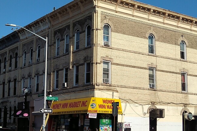
Property Record
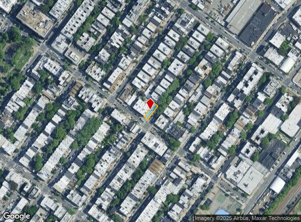
847 Knickerbocker Ave, Brooklyn, NY 11207
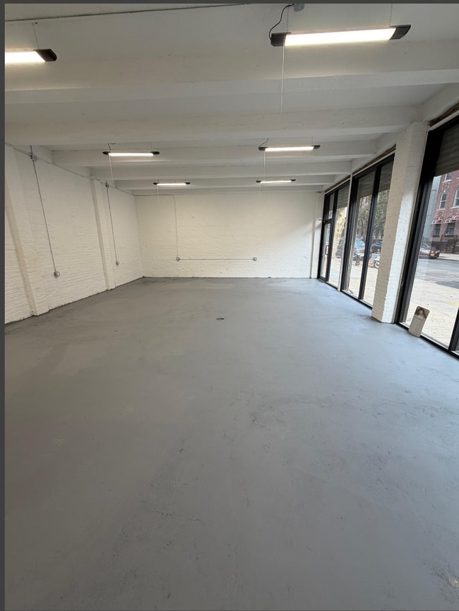

Current Lease Availabilities
Property Detail
847 Knickerbocker Ave
03425-0001
Kings
Commercialofficeresidentialmixeduse
New York
X
1
3604970209F
0.06 AC
2024
Bushwick
2025
Long Island (New York)
040900
New York-Jersey City-White Plains, NY-NJ
4,875 SF
NEARBY LISTINGS FOR SALE OR LEASE
DEMOGRAPHICS near 847 Knickerbocker Ave
1 mile
3 mile
5 mile
2024 Total Population
126,722
1,025,300
2,790,594
2029 Population
116,874
954,634
2,616,413
Pop Growth 2024-2029
(7.77%)
(6.89%)
(6.24%)
Average Age
37
37
39
2024 Total Households
44,890
366,379
1,060,836
HH Growth 2024-2029
(8.30%)
(7.36%)
(6.43%)
Median Household Inc
$66,212
$60,730
$73,519
Avg Household Size
2.70
2.70
2.50
2024 Avg HH Vehicles
1.00
1.00
1.00
Median Home Value
$910,031
$774,926
$753,483
Median Year Built
1947
1948
1949
Nearby Places
Map Layers
Map Styles
 Street
 Aerial
Transit
 Traffic
 Biking
Places
Listings with unknown addresses are not visible on the map
- Restaurants
- Banks
- Shops
- Fitness
- Groceries
PUBLIC TRANSPORTATION
TRANSIT/SUBWAY
Halsey Street (L Line) (L - New York MTA Subway (The Subway))
Drive
Walk
Distance
Halsey Street (L Line) (L - New York MTA Subway (The Subway))
1 min
6 min
0.3 mi
Wilson Avenue (L - New York MTA Subway (The Subway))
Drive
Walk
Distance
Wilson Avenue (L - New York MTA Subway (The Subway))
3 min
7 min
0.4 mi
Chauncey Street (J - New York MTA Subway (The Subway), Z - New York MTA Subway (The Subway))
Drive
Walk
Distance
Chauncey Street (J - New York MTA Subway (The Subway), Z - New York MTA Subway (The Subway))
2 min
15 min
0.8 mi
Myrtle-Wyckoff Avenues (L - New York MTA Subway (The Subway), M - New York MTA Subway (The Subway))
Drive
Walk
Distance
Myrtle-Wyckoff Avenues (L - New York MTA Subway (The Subway), M - New York MTA Subway (The Subway))
2 min
15 min
0.8 mi
Bushwick Avenue-Aberdeen Street (L - New York MTA Subway (The Subway))
Drive
Walk
Distance
Bushwick Avenue-Aberdeen Street (L - New York MTA Subway (The Subway))
2 min
18 min
1.0 mi
COMMUTER RAIL
East New York Station (Far Rockaway Branch - Long Island Rail Road, Long Beach Branch - Long Island Rail Road, West Hempstead Branch - Long Island Rail Road)
Drive
Walk
Distance
East New York Station (Far Rockaway Branch - Long Island Rail Road, Long Beach Branch - Long Island Rail Road, West Hempstead Branch - Long Island Rail Road)
4 min
1.7 mi
Nostrand Avenue Station (Far Rockaway Branch - Long Island Rail Road, Hempstead Branch - Long Island Rail Road, Long Beach Branch - Long Island Rail Road, West Hempstead Branch - Long Island Rail Road)
Drive
Walk
Distance
Nostrand Avenue Station (Far Rockaway Branch - Long Island Rail Road, Hempstead Branch - Long Island Rail Road, Long Beach Branch - Long Island Rail Road, West Hempstead Branch - Long Island Rail Road)
9 min
3.1 mi
AIRPORT
LaGuardia
Drive
Walk
Distance
LaGuardia
18 min
7.9 mi
John F Kennedy International
Drive
Walk
Distance
John F Kennedy International
18 min
10.9 mi
Newark Liberty International
Drive
Walk
Distance
Newark Liberty International
34 min
18.0 mi
Freight Ports
NY - Red Hook Container Terminal
Drive
Walk
Distance
NY - Red Hook Container Terminal
16 min
6.7 mi
Nearby Properties
Address
Land Use
TOTAL SIZE
Lot Size
Zoning
Address
Land Use
TOTAL SIZE
Lot Size
Zoning
2,812,739 SF
2.10 AC
C5-3
Address
Land Use
TOTAL SIZE
Lot Size
Zoning
54,170 SF
229.57 AC
PARK
Address
Land Use
TOTAL SIZE
Lot Size
Zoning
835,231 SF
11.32 AC
R6
Address
Land Use
TOTAL SIZE
Lot Size
Zoning
561,945 SF
11.58 AC
R6
Address
Land Use
TOTAL SIZE
Lot Size
Zoning
264,691 SF
5.17 AC
M1-2
Address
Land Use
TOTAL SIZE
Lot Size
Zoning
1,000 SF
210.07 AC
R3-2
Address
Land Use
TOTAL SIZE
Lot Size
Zoning
1,572,198 SF
22.06 AC
M1-2
Address
Land Use
TOTAL SIZE
Lot Size
Zoning
511,776 SF
2.33 AC
R6
Address
Land Use
TOTAL SIZE
Lot Size
Zoning
826,915 SF
8.83 AC
M3-1
Address
Land Use
TOTAL SIZE
Lot Size
Zoning
446,763 SF
12.52 AC
R6
Address
Land Use
TOTAL SIZE
Lot Size
Zoning
1,150,500 SF
15.17 AC
R6
Address
Land Use
TOTAL SIZE
Lot Size
Zoning
307,038 SF
7.84 AC
M1-1
Address
Land Use
TOTAL SIZE
Lot Size
Zoning
894,000 SF
4.14 AC
R6
Address
Land Use
TOTAL SIZE
Lot Size
Zoning
894,000 SF
4.14 AC
R6
Address
Land Use
TOTAL SIZE
Lot Size
Zoning
894,000 SF
4.14 AC
R6
Address
Land Use
TOTAL SIZE
Lot Size
Zoning
894,000 SF
4.14 AC
R6
Address
Land Use
TOTAL SIZE
Lot Size
Zoning
894,000 SF
4.14 AC
R6
Address
Land Use
TOTAL SIZE
Lot Size
Zoning
474,715 SF
1.72 AC
M14R8A
Address
Land Use
TOTAL SIZE
Lot Size
Zoning
458,778 SF
2.09 AC
R6
Address
Land Use
TOTAL SIZE
Lot Size
Zoning
160,890 SF
0.58 AC
R10
Address
Land Use
TOTAL SIZE
Lot Size
Zoning
490,600 SF
12.01 AC
M1-1
Address
Land Use
TOTAL SIZE
Lot Size
Zoning
758,750 SF
5.95 AC
R6
Address
Land Use
TOTAL SIZE
Lot Size
Zoning
758,750 SF
5.95 AC
R6
Address
Land Use
TOTAL SIZE
Lot Size
Zoning
751,412 SF
5.91 AC
R6
Address
Land Use
TOTAL SIZE
Lot Size
Zoning
751,412 SF
5.91 AC
R6
Address
Land Use
TOTAL SIZE
Lot Size
Zoning
751,412 SF
5.91 AC
R6
Address
Land Use
TOTAL SIZE
Lot Size
Zoning
635,994 SF
17.90 AC
R5
Address
Land Use
TOTAL SIZE
Lot Size
Zoning
273,583 SF
0.52 AC
R8B
Address
Land Use
TOTAL SIZE
Lot Size
Zoning
257,660 SF
1.94 AC
R7A
Address
Land Use
TOTAL SIZE
Lot Size
Zoning
447,000 SF
1.98 AC
R6
The World's #1 Commercial Real Estate Marketplace
Connect with us
© 2026 CoStar Group
The information above has been obtained from sources believed reliable. While we do not doubt its accuracy we have not verified it and make no guarantee, warranty or representation about it. It is your responsibility to independently confirm its accuracy and completeness. Any projections, opinions, assumptions, or estimates used are for example only and do not represent the current or future performance of the property. The value of this transaction to you depends on tax and other factors which should be evaluated by your tax, financial, and legal advisors. You and your advisors should conduct a careful, independent investigation of the property to determine to your satisfaction the suitability of the property for your needs.