Property Record
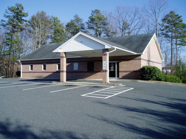
847 W Westlake Dr, Mount Airy, NC 27030


NEARBY LISTINGS FOR SALE OR LEASE
-
-
View all Mount Airy listings for sale on LoopNet.com
Property Detail
847 W Westlake Dr
5021-13-04-9636
Galax-Boggs
Medicalbuilding
PB12 PG27
X
Surry
3711502100J
North Carolina
2025
2.29 AC
2025
Hickory/Morganton
930502
Other Market Areas
6,072 SF
Mount Airy, NC
DEMOGRAPHICS near 847 W Westlake Dr
1 Mile
3 Mile
5 Mile
2024 Total Population
1,545
15,423
26,997
2029 Population
1,559
15,588
27,224
Pop Growth 2024-2029
+ 0.91%
+ 1.07%
+ 0.84%
Average Age
48
44
44
2024 Total Households
669
6,802
11,743
HH Growth 2024-2029
+ 1.05%
+ 1.10%
+ 0.84%
Median Household Inc
$33,548
$47,129
$46,577
Avg Household Size
2.10
2.20
2.20
2024 Avg HH Vehicles
2.00
2.00
2.00
Median Home Value
$163,809
$168,768
$150,052
Median Year Built
1975
1972
1974
Nearby Places
Map Layers
Map Styles
 Street
 Aerial
- Restaurants
- Banks
- Shops
- Fitness
- Groceries
SALE & LEASE HISTORY
LISTING DATE
SALE/LEASE

Feb 15, 2017
For Sale
Nearby Properties
Address
Land Use
TOTAL SIZE
Lot Size
Zoning
Address
Land Use
TOTAL SIZE
Lot Size
Zoning
240,171 SF
12 AC
B5
Address
Land Use
TOTAL SIZE
Lot Size
Zoning
200,663 SF
10.49 AC
R8
Address
Land Use
TOTAL SIZE
Lot Size
Zoning
87,468 SF
41.57 AC
RA
Address
Land Use
TOTAL SIZE
Lot Size
Zoning
86,738 SF
29.44 AC
R6
Address
Land Use
TOTAL SIZE
Lot Size
Zoning
12,088 SF
37.77 AC
RL
Address
Land Use
TOTAL SIZE
Lot Size
Zoning
112,521 SF
10.33 AC
B4
Address
Land Use
TOTAL SIZE
Lot Size
Zoning
10,592 SF
18.17 AC
CU-B5
Address
Land Use
TOTAL SIZE
Lot Size
Zoning
77,952 SF
48 AC
HB
Address
Land Use
TOTAL SIZE
Lot Size
Zoning
79,958 SF
20.05 AC
R8
Address
Land Use
TOTAL SIZE
Lot Size
Zoning
9,180 SF
214 AC
MI
Address
Land Use
TOTAL SIZE
Lot Size
Zoning
60,016 SF
10.16 AC
R8
Address
Land Use
TOTAL SIZE
Lot Size
Zoning
108,476 SF
14.17 AC
B4
Address
Land Use
TOTAL SIZE
Lot Size
Zoning
39,656 SF
11.65 AC
B2
Address
Land Use
TOTAL SIZE
Lot Size
Zoning
162,322 SF
35 AC
M1
Address
Land Use
TOTAL SIZE
Lot Size
Zoning
60,252 SF
8.34 AC
B4
Address
Land Use
TOTAL SIZE
Lot Size
Zoning
24,213 SF
4.08 AC
B5
Address
Land Use
TOTAL SIZE
Lot Size
Zoning
51,045 SF
2.60 AC
R6
Address
Land Use
TOTAL SIZE
Lot Size
Zoning
26,394 SF
3.62 AC
M1
Address
Land Use
TOTAL SIZE
Lot Size
Zoning
36,664 SF
5.36 AC
B5
Address
Land Use
TOTAL SIZE
Lot Size
Zoning
171,232 SF
22.65 AC
M1
Address
Land Use
TOTAL SIZE
Lot Size
Zoning
49,606 SF
0.59 AC
B2
Address
Land Use
TOTAL SIZE
Lot Size
Zoning
30,234 SF
2.60 AC
M1
Address
Land Use
TOTAL SIZE
Lot Size
Zoning
54,310 SF
B4
Address
Land Use
TOTAL SIZE
Lot Size
Zoning
57,205 SF
6.03 AC
B2
Address
Land Use
TOTAL SIZE
Lot Size
Zoning
41,250 SF
4.78 AC
B2
Address
Land Use
TOTAL SIZE
Lot Size
Zoning
18,666 SF
2 AC
B4
Address
Land Use
TOTAL SIZE
Lot Size
Zoning
21,994 SF
2.50 AC
B2
Address
Land Use
TOTAL SIZE
Lot Size
Zoning
214,212 SF
27.17 AC
M1
Address
Land Use
TOTAL SIZE
Lot Size
Zoning
29,785 SF
4.90 AC
R8
Address
Land Use
TOTAL SIZE
Lot Size
Zoning
1,664 SF
6.20 AC
CU-R6
The World's #1 Commercial Real Estate Marketplace
Connect with us
© 2026 CoStar Group
The information above has been obtained from sources believed reliable. While we do not doubt its accuracy we have not verified it and make no guarantee, warranty or representation about it. It is your responsibility to independently confirm its accuracy and completeness. Any projections, opinions, assumptions, or estimates used are for example only and do not represent the current or future performance of the property. The value of this transaction to you depends on tax and other factors which should be evaluated by your tax, financial, and legal advisors. You and your advisors should conduct a careful, independent investigation of the property to determine to your satisfaction the suitability of the property for your needs.