Property Record
8474 W Mount Morris Rd, Flushing, MI 48433
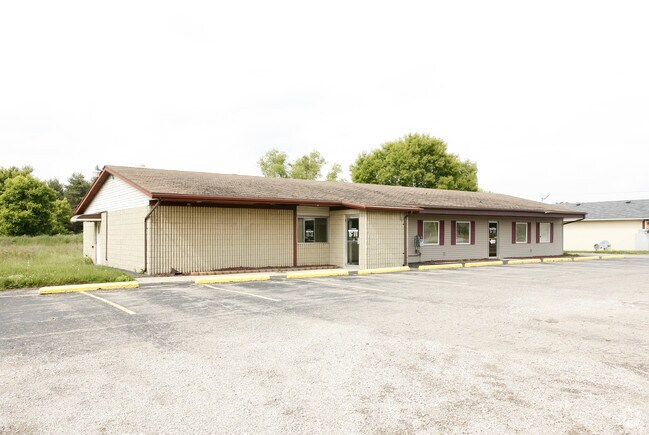

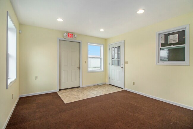
Property Detail
8474 W Mount Morris Rd
08-02-300-010
A PARCEL OF LAND BEG 300 FT E OF SW COR OF SEC TH E 177 FT TH N 1 DEG 28 MIN W 400 FT TH W 177 FT TH S 1 DEG 28 MIN E 400 FT
Commercialnec
Genesee
C-2
Michigan
B and X Area of moderate flood hazard, usually the area between the limits of the 100-year and 500-year floods.
1.63 AC
2024
Flint
2025
Detroit
010610
Flint, MI
6,608 SF
NEARBY LISTINGS FOR SALE OR LEASE
DEMOGRAPHICS near 8474 W Mount Morris Rd
1 mile
3 mile
5 mile
2025 Total Population
1,229
9,020
28,022
2030 Population
1,229
8,884
27,371
Pop Growth 2025-2030
0.00%
(1.51%)
(2.32%)
Average Age
43
42
43
2025 Total Households
458
3,384
11,111
HH Growth 2025-2030
0.00%
(1.54%)
(2.37%)
Median Household Inc
$59,450
$81,290
$74,672
Avg Household Size
2.60
2.60
2.50
2025 Avg HH Vehicles
2.00
2.00
2.00
Median Home Value
$186,431
$209,488
$198,434
Median Year Built
1976
1973
1970
Nearby Places
Map Layers
Map Styles
 Street
 Aerial
Transit
 Traffic
 Biking
Places
Listings with unknown addresses are not visible on the map
- Restaurants
- Banks
- Shops
- Fitness
- Groceries
PUBLIC TRANSPORTATION
AIRPORT
Bishop International
Drive
Walk
Distance
Bishop International
36 min
16.9 mi
Freight Ports
Port of Toledo
Drive
Walk
Distance
Port of Toledo
150 min
124.7 mi
SALE & LEASE HISTORY
LISTING DATE
SALE/LEASE

May 17, 2017
For Sale
Apr 27, 2022
For Sale
Nearby Properties
Address
Land Use
TOTAL SIZE
Lot Size
Zoning
Address
Land Use
TOTAL SIZE
Lot Size
Zoning
5,176 SF
53 AC
RU-4
Address
Land Use
TOTAL SIZE
Lot Size
Zoning
2,990 SF
102.74 AC
RU-4
Address
Land Use
TOTAL SIZE
Lot Size
Zoning
160.41 AC
RF-RESID F
Address
Land Use
TOTAL SIZE
Lot Size
Zoning
5.18 AC
C-2
Address
Land Use
TOTAL SIZE
Lot Size
Zoning
11,088 SF
2 AC
RU-3
Address
Land Use
TOTAL SIZE
Lot Size
Zoning
Address
Land Use
TOTAL SIZE
Lot Size
Zoning
9,100 SF
2.52 AC
C-2
Address
Land Use
TOTAL SIZE
Lot Size
Zoning
2,250 SF
76.70 AC
RSA
Address
Land Use
TOTAL SIZE
Lot Size
Zoning
1,316 SF
23.80 AC
RU-4
Address
Land Use
TOTAL SIZE
Lot Size
Zoning
1,872 SF
62.75 AC
RSA
Address
Land Use
TOTAL SIZE
Lot Size
Zoning
7,698 SF
10 AC
RSA/SU
Address
Land Use
TOTAL SIZE
Lot Size
Zoning
1,645 SF
66.57 AC
RSA
Address
Land Use
TOTAL SIZE
Lot Size
Zoning
113.16 AC
Address
Land Use
TOTAL SIZE
Lot Size
Zoning
2,736 SF
20 AC
RF-RESID F
Address
Land Use
TOTAL SIZE
Lot Size
Zoning
1,528 SF
80 AC
RSA
Address
Land Use
TOTAL SIZE
Lot Size
Zoning
1,800 SF
79 AC
RSA
Address
Land Use
TOTAL SIZE
Lot Size
Zoning
7,539 SF
4.70 AC
RSA
Address
Land Use
TOTAL SIZE
Lot Size
Zoning
83.67 AC
RSA
Address
Land Use
TOTAL SIZE
Lot Size
Zoning
123 AC
AG-AGRICUL
Address
Land Use
TOTAL SIZE
Lot Size
Zoning
118.50 AC
RSA
Address
Land Use
TOTAL SIZE
Lot Size
Zoning
5.34 AC
Address
Land Use
TOTAL SIZE
Lot Size
Zoning
2,170 SF
63.42 AC
RSA
Address
Land Use
TOTAL SIZE
Lot Size
Zoning
2,127 SF
10.30 AC
RSA
Address
Land Use
TOTAL SIZE
Lot Size
Zoning
1,412 SF
80.30 AC
RSA
Address
Land Use
TOTAL SIZE
Lot Size
Zoning
79.30 AC
RSA
Address
Land Use
TOTAL SIZE
Lot Size
Zoning
107 AC
RU-4
Address
Land Use
TOTAL SIZE
Lot Size
Zoning
55 AC
RSA
Address
Land Use
TOTAL SIZE
Lot Size
Zoning
1,226 SF
70 AC
RSA
Address
Land Use
TOTAL SIZE
Lot Size
Zoning
1,196 SF
70.03 AC
RSA
Address
Land Use
TOTAL SIZE
Lot Size
Zoning
The World's #1 Commercial Real Estate Marketplace
Connect with us
© 2026 CoStar Group
The information above has been obtained from sources believed reliable. While we do not doubt its accuracy we have not verified it and make no guarantee, warranty or representation about it. It is your responsibility to independently confirm its accuracy and completeness. Any projections, opinions, assumptions, or estimates used are for example only and do not represent the current or future performance of the property. The value of this transaction to you depends on tax and other factors which should be evaluated by your tax, financial, and legal advisors. You and your advisors should conduct a careful, independent investigation of the property to determine to your satisfaction the suitability of the property for your needs.