Property Record
8475 Corcoran Rd, Willow Springs, IL 60480


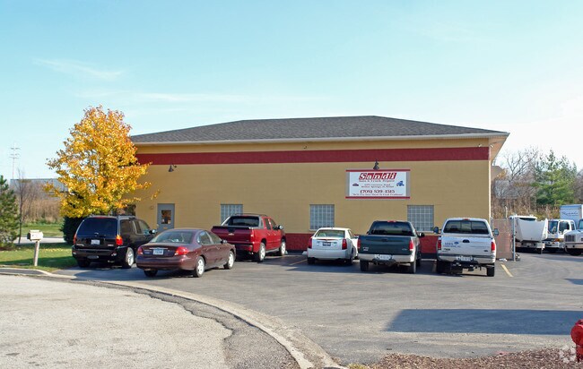
Property Detail
8475 Corcoran Rd
18-32-401-020-0000
Cook
Parkingstructure
Illinois
B and X Area of moderate flood hazard, usually the area between the limits of the 100-year and 500-year floods.
4
2023
0.46 AC
2025
North I-55 Corridor
820203
Chicago
2,865 SF
Chicago-Naperville-Elgin, IL-IN
NEARBY LISTINGS FOR SALE OR LEASE
DEMOGRAPHICS near 8475 Corcoran Rd
1 mile
3 mile
5 mile
2025 Total Population
4,524
44,297
174,410
2030 Population
4,583
45,008
176,610
Pop Growth 2025-2030
+ 1.30%
+ 1.61%
+ 1.26%
Average Age
45
44
42
2025 Total Households
1,754
17,133
65,843
HH Growth 2025-2030
+ 1.08%
+ 1.38%
+ 1.13%
Median Household Inc
$111,111
$91,196
$90,684
Avg Household Size
2.60
2.50
2.60
2025 Avg HH Vehicles
2.00
2.00
2.00
Median Home Value
$406,473
$352,829
$354,716
Median Year Built
1982
1978
1975
Nearby Places
Map Layers
Map Styles
 Street
 Aerial
Layers
 Traffic
 Biking
Places
Listings with unknown addresses are not visible on the map
- Restaurants
- Banks
- Shops
- Fitness
- Groceries
PUBLIC TRANSPORTATION
COMMUTER RAIL
Willow Springs Station (Heritage Corridor Line - Northeast Illinois Regional Commuter Railroad (Metra))
Drive
Walk
Distance
Willow Springs Station (Heritage Corridor Line - Northeast Illinois Regional Commuter Railroad (Metra))
2 min
9 min
0.5 mi
Highlands Station (Burlington Northern-Santa Fe Railway Line - Northeast Illinois Regional Commuter Railroad (Metra))
Drive
Walk
Distance
Highlands Station (Burlington Northern-Santa Fe Railway Line - Northeast Illinois Regional Commuter Railroad (Metra))
15 min
6.9 mi
AIRPORT
Chicago Midway International
Drive
Walk
Distance
Chicago Midway International
17 min
9.6 mi
Chicago O'Hare International
Drive
Walk
Distance
Chicago O'Hare International
35 min
23.7 mi
Freight Ports
Port Milwaukee
Drive
Walk
Distance
Port Milwaukee
117 min
95.4 mi
Nearby Properties
Address
Land Use
TOTAL SIZE
Lot Size
Zoning
Address
Land Use
TOTAL SIZE
Lot Size
Zoning
96.60 AC
Address
Land Use
TOTAL SIZE
Lot Size
Zoning
68.06 AC
Address
Land Use
TOTAL SIZE
Lot Size
Zoning
436,456 SF
59.11 AC
I
Address
Land Use
TOTAL SIZE
Lot Size
Zoning
104,912 SF
6.91 AC
Address
Land Use
TOTAL SIZE
Lot Size
Zoning
289,314 SF
2.79 AC
Address
Land Use
TOTAL SIZE
Lot Size
Zoning
110,584 SF
5.57 AC
Address
Land Use
TOTAL SIZE
Lot Size
Zoning
195,000 SF
10.18 AC
Address
Land Use
TOTAL SIZE
Lot Size
Zoning
49,503 SF
1.47 AC
Address
Land Use
TOTAL SIZE
Lot Size
Zoning
16,077 SF
66.23 AC
Address
Land Use
TOTAL SIZE
Lot Size
Zoning
215,631 SF
23.94 AC
I
Address
Land Use
TOTAL SIZE
Lot Size
Zoning
52,887 SF
4.64 AC
C
Address
Land Use
TOTAL SIZE
Lot Size
Zoning
Address
Land Use
TOTAL SIZE
Lot Size
Zoning
134,235 SF
7.96 AC
Address
Land Use
TOTAL SIZE
Lot Size
Zoning
105,562 SF
9.64 AC
Address
Land Use
TOTAL SIZE
Lot Size
Zoning
98,811 SF
10.02 AC
Address
Land Use
TOTAL SIZE
Lot Size
Zoning
79,232 SF
3.19 AC
C
Address
Land Use
TOTAL SIZE
Lot Size
Zoning
14,400 SF
0.80 AC
Address
Land Use
TOTAL SIZE
Lot Size
Zoning
76,701 SF
5.02 AC
C
Address
Land Use
TOTAL SIZE
Lot Size
Zoning
136,618 SF
19.66 AC
I
Address
Land Use
TOTAL SIZE
Lot Size
Zoning
45,684 SF
4.24 AC
C
Address
Land Use
TOTAL SIZE
Lot Size
Zoning
63,231 SF
2.53 AC
Address
Land Use
TOTAL SIZE
Lot Size
Zoning
54,000 SF
5.22 AC
I
Address
Land Use
TOTAL SIZE
Lot Size
Zoning
2,056,254 SF
22.98 AC
Address
Land Use
TOTAL SIZE
Lot Size
Zoning
3.51 AC
Address
Land Use
TOTAL SIZE
Lot Size
Zoning
49,971 SF
3.80 AC
Address
Land Use
TOTAL SIZE
Lot Size
Zoning
47,976 SF
0.37 AC
C
Address
Land Use
TOTAL SIZE
Lot Size
Zoning
15,600 SF
9.35 AC
Address
Land Use
TOTAL SIZE
Lot Size
Zoning
Address
Land Use
TOTAL SIZE
Lot Size
Zoning
111,038 SF
3.44 AC
N
Address
Land Use
TOTAL SIZE
Lot Size
Zoning
24,988 SF
1.41 AC
C
The World's #1 Commercial Real Estate Marketplace
Connect with us
© 2026 CoStar Group
The information above has been obtained from sources believed reliable. While we do not doubt its accuracy we have not verified it and make no guarantee, warranty or representation about it. It is your responsibility to independently confirm its accuracy and completeness. Any projections, opinions, assumptions, or estimates used are for example only and do not represent the current or future performance of the property. The value of this transaction to you depends on tax and other factors which should be evaluated by your tax, financial, and legal advisors. You and your advisors should conduct a careful, independent investigation of the property to determine to your satisfaction the suitability of the property for your needs.