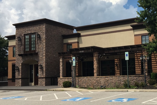
Property Record
848 Se Maynard Rd, Cary, NC 27511
NEARBY LISTINGS FOR SALE OR LEASE
Property Detail
848 Se Maynard Rd
Raleigh, NC
Dillards & Cary Venture Lmtd Prtnshp
0773.09-16-3696-000
Wake
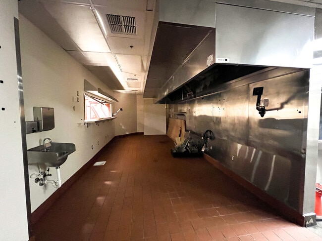
Restaurantbuilding
North Carolina
X
67.76 AC
3720077300K
Cary
220,152 SF
Raleigh/Durham
DEMOGRAPHICS near 848 Se Maynard Rd
1 Mile
3 Mile
5 Mile
2024 Total Population
9,777
84,661
191,498
2029 Population
10,595
91,888
207,729
Pop Growth 2024-2029
+ 8.37%
+ 8.54%
+ 8.48%
Average Age
40
39
38
2024 Total Households
3,841
36,971
79,790
HH Growth 2024-2029
+ 8.41%
+ 8.62%
+ 8.66%
Median Household Inc
$83,226
$79,828
$86,339
Avg Household Size
2.40
2.20
2.30
2024 Avg HH Vehicles
2.00
2.00
2.00
Median Home Value
$350,736
$371,867
$415,918
Median Year Built
1978
1989
1992
Nearby Places
Map Layers
Map Styles
 Street
 Aerial
- Restaurants
- Banks
- Shops
- Fitness
- Groceries
PUBLIC TRANSPORTATION
COMMUTER RAIL
Cary Station (Piedmont - North Carolina by Train (NC Train))
DRIVE
WALK
Distance
Cary Station (Piedmont - North Carolina by Train (NC Train))
5 min
2.0 mi
Raleigh Union Station (Piedmont - North Carolina by Train (NC Train))
DRIVE
WALK
Distance
Raleigh Union Station (Piedmont - North Carolina by Train (NC Train))
13 min
8.4 mi
AIRPORT
Raleigh-Durham International
DRIVE
WALK
Distance
Raleigh-Durham International
16 min
10.1 mi
Freight Ports
Port of Wilmington
DRIVE
WALK
Distance
Port of Wilmington
158 min
139.1 mi
SALE & LEASE HISTORY
LISTING DATE
SALE/LEASE

Nov 19, 2018
For Lease
Jul 28, 2017
For Lease
Aug 17, 2018
For Lease
Nearby Properties
Address
Land Use
TOTAL SIZE
Lot Size
Zoning
Address
Land Use
TOTAL SIZE
Lot Size
Zoning
770,311 SF
80.70 AC
PD
Address
Land Use
TOTAL SIZE
Lot Size
Zoning
693,180 SF
17.61 AC
GCM
Address
Land Use
TOTAL SIZE
Lot Size
Zoning
633,930 SF
23.01 AC
OI
Address
Land Use
TOTAL SIZE
Lot Size
Zoning
439,439 SF
30.59 AC
OICU
Address
Land Use
TOTAL SIZE
Lot Size
Zoning
433,914 SF
11.81 AC
MXD
Address
Land Use
TOTAL SIZE
Lot Size
Zoning
416,361 SF
38.41 AC
ORD
Address
Land Use
TOTAL SIZE
Lot Size
Zoning
441,502 SF
15.42 AC
OIM
Address
Land Use
TOTAL SIZE
Lot Size
Zoning
378,159 SF
22.40 AC
OX-7
Address
Land Use
TOTAL SIZE
Lot Size
Zoning
395,263 SF
6.07 AC
CX-5
Address
Land Use
TOTAL SIZE
Lot Size
Zoning
392,141 SF
24.49 AC
RMFM
Address
Land Use
TOTAL SIZE
Lot Size
Zoning
308,622 SF
14.34 AC
CX-5
Address
Land Use
TOTAL SIZE
Lot Size
Zoning
402,447 SF
49.88 AC
GC
Address
Land Use
TOTAL SIZE
Lot Size
Zoning
350,189 SF
15.77 AC
PD
Address
Land Use
TOTAL SIZE
Lot Size
Zoning
359,022 SF
21.46 AC
OX-3
Address
Land Use
TOTAL SIZE
Lot Size
Zoning
211,387 SF
36.72 AC
OX-3
Address
Land Use
TOTAL SIZE
Lot Size
Zoning
435,090 SF
28.82 AC
RMFP
Address
Land Use
TOTAL SIZE
Lot Size
Zoning
357,293 SF
25.23 AC
RX-3
Address
Land Use
TOTAL SIZE
Lot Size
Zoning
269,702 SF
14.66 AC
GCM
Address
Land Use
TOTAL SIZE
Lot Size
Zoning
387,626 SF
18.48 AC
RMFM
Address
Land Use
TOTAL SIZE
Lot Size
Zoning
382,324 SF
14.85 AC
OX-7
Address
Land Use
TOTAL SIZE
Lot Size
Zoning
341,943 SF
19.49 AC
RMFP
Address
Land Use
TOTAL SIZE
Lot Size
Zoning
290,022 SF
14.76 AC
RX-3
Address
Land Use
TOTAL SIZE
Lot Size
Zoning
314,623 SF
49.66 AC
R-10
Address
Land Use
TOTAL SIZE
Lot Size
Zoning
242,847 SF
17.75 AC
RX-3
Address
Land Use
TOTAL SIZE
Lot Size
Zoning
364,972 SF
35.18 AC
RMF-C
Address
Land Use
TOTAL SIZE
Lot Size
Zoning
242,305 SF
48.57 AC
R40
Address
Land Use
TOTAL SIZE
Lot Size
Zoning
226,107 SF
18.72 AC
RMFP
Address
Land Use
TOTAL SIZE
Lot Size
Zoning
194,462 SF
21.62 AC
OICU
Address
Land Use
TOTAL SIZE
Lot Size
Zoning
330,232 SF
18.45 AC
OIP
The World's #1 Commercial Real Estate Marketplace
Connect with us
© 2025 CoStar Group
The information above has been obtained from sources believed reliable. While we do not doubt its accuracy we have not verified it and make no guarantee, warranty or representation about it. It is your responsibility to independently confirm its accuracy and completeness. Any projections, opinions, assumptions, or estimates used are for example only and do not represent the current or future performance of the property. The value of this transaction to you depends on tax and other factors which should be evaluated by your tax, financial, and legal advisors. You and your advisors should conduct a careful, independent investigation of the property to determine to your satisfaction the suitability of the property for your needs.