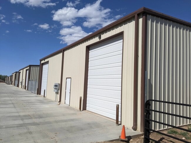
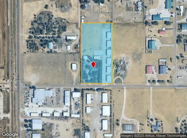
Property Record
8500 Sw 81St Ave, Amarillo, TX 79119
Current Lease Availabilities
Property Detail
8500 Sw 81St Ave
Amarillo, TX
Coulter Acres
R-009-2600-1550
COULTER ACRES, BLK 0002, LOT 11 LESS TR IN SW COR, 3.5280 ACRES
Utilities
Randall
X
Texas
48375C0520C
11
2024
4.77 AC
2025
Amarillo
021611
Other Market Areas
20,393 SF
NEARBY LISTINGS FOR SALE OR LEASE
-
-
View all Amarillo listings for lease on LoopNet.com
DEMOGRAPHICS near 8500 Sw 81St Ave
1 mile
3 mile
5 mile
2024 Total Population
6,279
39,112
96,227
2029 Population
6,972
43,064
105,031
Pop Growth 2024-2029
+ 11.04%
+ 10.10%
+ 9.15%
Average Age
39
41
39
2024 Total Households
2,535
16,194
39,771
HH Growth 2024-2029
+ 11.16%
+ 10.21%
+ 9.26%
Median Household Inc
$84,722
$85,771
$72,703
Avg Household Size
2.40
2.40
2.30
2024 Avg HH Vehicles
2.00
2.00
2.00
Median Home Value
$245,523
$240,672
$202,623
Median Year Built
2010
1999
1985
Nearby Places
Map Layers
Map Styles
 Street
 Aerial
Transit
 Traffic
 Biking
Places
Listings with unknown addresses are not visible on the map
- Restaurants
- Banks
- Shops
- Fitness
- Groceries
PUBLIC TRANSPORTATION
AIRPORT
Rick Husband Amarillo International
Drive
Walk
Distance
Rick Husband Amarillo International
25 min
19.4 mi
Freight Ports
Tulsa Port Of Catoosa
Drive
Walk
Distance
Tulsa Port Of Catoosa
407 min
387.4 mi
Nearby Properties
Address
Land Use
TOTAL SIZE
Lot Size
Zoning
Address
Land Use
TOTAL SIZE
Lot Size
Zoning
362,796 SF
49.98 AC
A
Address
Land Use
TOTAL SIZE
Lot Size
Zoning
269,713 SF
57.96 AC
Address
Land Use
TOTAL SIZE
Lot Size
Zoning
258,757 SF
22.78 AC
A
Address
Land Use
TOTAL SIZE
Lot Size
Zoning
373,014 SF
14.20 AC
Address
Land Use
TOTAL SIZE
Lot Size
Zoning
128,970 SF
15.03 AC
Address
Land Use
TOTAL SIZE
Lot Size
Zoning
270,379 SF
12.12 AC
Address
Land Use
TOTAL SIZE
Lot Size
Zoning
260,680 SF
10.16 AC
Address
Land Use
TOTAL SIZE
Lot Size
Zoning
88,841 SF
10.97 AC
R3
Address
Land Use
TOTAL SIZE
Lot Size
Zoning
251,520 SF
9.84 AC
GR
Address
Land Use
TOTAL SIZE
Lot Size
Zoning
92,109 SF
16.03 AC
Address
Land Use
TOTAL SIZE
Lot Size
Zoning
190,074 SF
12.07 AC
Address
Land Use
TOTAL SIZE
Lot Size
Zoning
161,321 SF
31 AC
A
Address
Land Use
TOTAL SIZE
Lot Size
Zoning
69,391 SF
6.99 AC
A
Address
Land Use
TOTAL SIZE
Lot Size
Zoning
119,618 SF
11.70 AC
R2
Address
Land Use
TOTAL SIZE
Lot Size
Zoning
161,221 SF
11.78 AC
MF1
Address
Land Use
TOTAL SIZE
Lot Size
Zoning
112,005 SF
7.70 AC
GR
Address
Land Use
TOTAL SIZE
Lot Size
Zoning
227,707 SF
10.78 AC
GR
Address
Land Use
TOTAL SIZE
Lot Size
Zoning
186,001 SF
2.79 AC
PD
Address
Land Use
TOTAL SIZE
Lot Size
Zoning
186,001 SF
2.79 AC
PD
Address
Land Use
TOTAL SIZE
Lot Size
Zoning
186,001 SF
2.79 AC
PD
Address
Land Use
TOTAL SIZE
Lot Size
Zoning
186,001 SF
2.79 AC
PD
Address
Land Use
TOTAL SIZE
Lot Size
Zoning
89,173 SF
9.55 AC
PD
Address
Land Use
TOTAL SIZE
Lot Size
Zoning
185,895 SF
9.59 AC
Address
Land Use
TOTAL SIZE
Lot Size
Zoning
69,009 SF
37.97 AC
Address
Land Use
TOTAL SIZE
Lot Size
Zoning
187,253 SF
9.69 AC
PD
Address
Land Use
TOTAL SIZE
Lot Size
Zoning
84,200 SF
7.99 AC
Address
Land Use
TOTAL SIZE
Lot Size
Zoning
207,352 SF
26.15 AC
A
Address
Land Use
TOTAL SIZE
Lot Size
Zoning
70,903 SF
7.30 AC
R2
Address
Land Use
TOTAL SIZE
Lot Size
Zoning
42,306 SF
8 AC
Address
Land Use
TOTAL SIZE
Lot Size
Zoning
69,100 SF
11.93 AC
The World's #1 Commercial Real Estate Marketplace
Connect with us
© 2026 CoStar Group
The information above has been obtained from sources believed reliable. While we do not doubt its accuracy we have not verified it and make no guarantee, warranty or representation about it. It is your responsibility to independently confirm its accuracy and completeness. Any projections, opinions, assumptions, or estimates used are for example only and do not represent the current or future performance of the property. The value of this transaction to you depends on tax and other factors which should be evaluated by your tax, financial, and legal advisors. You and your advisors should conduct a careful, independent investigation of the property to determine to your satisfaction the suitability of the property for your needs.