Property Record
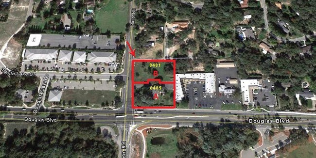
8481 Barton Rd, Granite Bay, CA 95746


Property Detail
8481 Barton Rd
048-101-084
1.67 AC PAR B & A PMOR 20 143
Hospitalprivate
PLACER
B and X Area of moderate flood hazard, usually the area between the limits of the 100-year and 500-year floods.
California
2024
1.67 AC
2025
Roseville/Rocklin
020604
Sacramento
32,537 SF
Sacramento-Roseville-Folsom, CA
NEARBY LISTINGS FOR SALE OR LEASE
DEMOGRAPHICS near 8481 Barton Rd
1 mile
3 mile
5 mile
2025 Total Population
3,736
42,227
139,594
2030 Population
3,927
44,130
144,122
Pop Growth 2025-2030
+ 5.11%
+ 4.51%
+ 3.24%
Average Age
45
44
43
2025 Total Households
1,338
15,414
51,314
HH Growth 2025-2030
+ 5.16%
+ 4.46%
+ 3.35%
Median Household Inc
$143,485
$143,783
$108,795
Avg Household Size
2.70
2.70
2.50
2025 Avg HH Vehicles
2.00
2.00
2.00
Median Home Value
$965,811
$869,578
$725,598
Median Year Built
1984
1993
1984
Nearby Places
Map Layers
Map Styles
 Street
 Aerial
Layers
 Traffic
 Biking
Places
Listings with unknown addresses are not visible on the map
- Restaurants
- Banks
- Shops
- Fitness
- Groceries
PUBLIC TRANSPORTATION
COMMUTER RAIL
Roseville Amtrak (California Zephyr - Amtrak, Capitol Corridor - Amtrak)
Drive
Walk
Distance
Roseville Amtrak (California Zephyr - Amtrak, Capitol Corridor - Amtrak)
13 min
6.1 mi
Rocklin Amtrak Station (Capitol Corridor - Amtrak)
Drive
Walk
Distance
Rocklin Amtrak Station (Capitol Corridor - Amtrak)
11 min
6.9 mi
AIRPORT
Sacramento International
Drive
Walk
Distance
Sacramento International
40 min
29.1 mi
Freight Ports
Port of Stockton
Drive
Walk
Distance
Port of Stockton
83 min
69.3 mi
Nearby Properties
Address
Land Use
TOTAL SIZE
Lot Size
Zoning
Address
Land Use
TOTAL SIZE
Lot Size
Zoning
638,040 SF
38.70 AC
Address
Land Use
TOTAL SIZE
Lot Size
Zoning
223,623 SF
12.70 AC
Address
Land Use
TOTAL SIZE
Lot Size
Zoning
120,983 SF
17.60 AC
Address
Land Use
TOTAL SIZE
Lot Size
Zoning
154,696 SF
10.80 AC
Address
Land Use
TOTAL SIZE
Lot Size
Zoning
142,063 SF
8.70 AC
Address
Land Use
TOTAL SIZE
Lot Size
Zoning
118,155 SF
3.80 AC
Address
Land Use
TOTAL SIZE
Lot Size
Zoning
96,522 SF
19.90 AC
FBX
Address
Land Use
TOTAL SIZE
Lot Size
Zoning
10,800 SF
6.70 AC
RAB100
Address
Land Use
TOTAL SIZE
Lot Size
Zoning
109,098 SF
5.50 AC
Address
Land Use
TOTAL SIZE
Lot Size
Zoning
111,418 SF
10.90 AC
Address
Land Use
TOTAL SIZE
Lot Size
Zoning
80,966 SF
21.80 AC
Address
Land Use
TOTAL SIZE
Lot Size
Zoning
121,155 SF
4.70 AC
C-2 (PD)
Address
Land Use
TOTAL SIZE
Lot Size
Zoning
137,447 SF
10.90 AC
C1UPDC
Address
Land Use
TOTAL SIZE
Lot Size
Zoning
254,982 SF
19.60 AC
Address
Land Use
TOTAL SIZE
Lot Size
Zoning
145,700 SF
9.30 AC
Address
Land Use
TOTAL SIZE
Lot Size
Zoning
116,300 SF
7.50 AC
Address
Land Use
TOTAL SIZE
Lot Size
Zoning
73,756 SF
6.60 AC
Address
Land Use
TOTAL SIZE
Lot Size
Zoning
107,500 SF
7.50 AC
Address
Land Use
TOTAL SIZE
Lot Size
Zoning
102,494 SF
7.70 AC
Address
Land Use
TOTAL SIZE
Lot Size
Zoning
97,278 SF
4.60 AC
Address
Land Use
TOTAL SIZE
Lot Size
Zoning
97,279 SF
6.40 AC
Address
Land Use
TOTAL SIZE
Lot Size
Zoning
60,069 SF
1.40 AC
Address
Land Use
TOTAL SIZE
Lot Size
Zoning
5,388 SF
2.80 AC
CPDDC
Address
Land Use
TOTAL SIZE
Lot Size
Zoning
73,900 SF
7 AC
Address
Land Use
TOTAL SIZE
Lot Size
Zoning
46,571 SF
4 AC
CPDDC
Address
Land Use
TOTAL SIZE
Lot Size
Zoning
31,722 SF
151.30 AC
RSAGB40
Address
Land Use
TOTAL SIZE
Lot Size
Zoning
69,120 SF
7.50 AC
Address
Land Use
TOTAL SIZE
Lot Size
Zoning
57,405 SF
7.20 AC
Address
Land Use
TOTAL SIZE
Lot Size
Zoning
59,181 SF
4.57 AC
C-2 (PD)
Address
Land Use
TOTAL SIZE
Lot Size
Zoning
48,170 SF
4 AC
The World's #1 Commercial Real Estate Marketplace
Connect with us
© 2026 CoStar Group
The information above has been obtained from sources believed reliable. While we do not doubt its accuracy we have not verified it and make no guarantee, warranty or representation about it. It is your responsibility to independently confirm its accuracy and completeness. Any projections, opinions, assumptions, or estimates used are for example only and do not represent the current or future performance of the property. The value of this transaction to you depends on tax and other factors which should be evaluated by your tax, financial, and legal advisors. You and your advisors should conduct a careful, independent investigation of the property to determine to your satisfaction the suitability of the property for your needs.